This West Seattle street was created in 1937 as part of Forest View Tracts, an addition to the City of Seattle. At the time, it truly was in the middle of the forest, and still today Fauntleroy Park, “a densely wooded patch of forest in West Seattle,” lies to its north and east.
Forest Court SW begins at SW Roxbury Street between 41st Avenue SW and 42nd Avenue SW and goes around 800 feet north to a Fauntleroy Park trailhead.
There does not appear to be any record of why Brace Point was so named. George Davidson (1825–1911) was a member of the Coast Survey in 1857, and as he explored Puget Sound named Fauntleroy Cove, Mount Ellinor, and Mount Constance (see Fauntleroy Way SW). Having named these as well as the twin Olympic Mountains peaks The Brothers after Robert Henry Fauntleroy (1806–1849) and his family, perhaps Brace was a name somehow associated with that family or his own? (They became one and the same, as Davidson married Ellinor Fauntleroy [1837–1907] in 1858.) Or, brace is a nautical term: “on a square-rigged ship… a rope (line) used to rotate a yard around the mast, to allow the ship to sail at different angles to the wind,” which could have been reason enough for a member of the Coast Survey to apply it to a landmark. As of this writing it remains a mystery.
Portion of 1857 U.S. Coast Survey map of Puget Sound. Some of these names are still in use to varying degrees, e.g., Meadow Point north of Golden Gardens Park, West Point in Magnolia, and Duwamish Head and Point Williams in West Seattle. Brace Point is just to the south of Point Williams. Battery Point, however, was long ago retired in favor of Alki Point.
SW Brace Point Drive begins at California Avenue SW as it passes Kilbourne Park. It goes just over ⅓ of a mile first southwest, then northwest (changing direction at 47th Avenue SW), to a shoreline street end on Puget Sound, seen below. (Ordinance 72001 seems to indicate that the beach portion of the street end was added in 1942.)
This West Seattle street was created in 1936 as Ocean View Way, part of the plat of Ocean View Addition to the City of Seattle. Even though the Pacific Ocean is 92 miles to the west, as the crow flies, I’m pretty sure the street and addition were named for Puget Sound — from the end of the street to the beach is about 500 feet.
SW Ocean View Drive begins at SW 112th Street and 35th Avenue SW and goes ⅕ of a mile southwest to Marine View Drive SW.
This West Seattle street was created in 1941 as part of Allan MacLean’s 1st Add’n to the City of Seattle, filed by Allan and Nellie MacLean; H.S. and Marie A. Kelsey; and, on behalf of Carroll Hillman and Hedlund Inc., J.L. Carroll and Clarence A. Hardesty. The narrow plat only had room for one newly named street, and apparently the Kelseys got that honor.
Marie Agnes Cunningham (1914–1976) and Horace Stephen Kelsey (1903–1961) appear to have gotten married the year before filing the plat. According to Mr. Kelsey’s obituary in The Seattle Times,
He was in commercial construction work until retiring in 1948.… He owned and built the Barbee Shipyard and Mill in Ballard, the Stanwood Shipyards and the Kennydale Shipyards during the war. He also constructed hundreds of houses in South Seattle.
Kelsey Lane SW begins at SW Barton Street between 21st Avenue SW and 22nd Avenue SW and goes ¼ of a mile south to the city limits at SW Roxbury Street.
The dean of Seattle local historians, Paul Dorpat, has died. Below is the obituary on his own site, written by longtime collaborators Jean Sherrard and Clay Eals.
I had the good fortune to make his acquaintance back when I was the “Seattle History Examiner,” sitting on the steering committee of the University District Museum Without Walls, and working on the first edition of my book. He encouraged my love of writing about local history, and I will forever be grateful.
(Incidentally, Chavez himself spelled his name without the acute accents, and I am following that convention here.)
The park was originally named in 1997, per King County motion 10325, which noted that “the triangular-shaped property… was purchased by METRO as part of the Effluent Transfer System Project (ETS),” and that “as mitigation… the King County water pollution control division… earmarked $15,000 to landscape [the] property.” As “South Park [was] known as one of Seattle’s more diverse neighborhoods with a population approximately 20% Hispanic; and… Cesar Chavez was for decades the voice not only of farmworkers, but of the entire* Latino community,” the King County Council honored the late Chavez, who had died in 1993, by putting his name on the park. It stayed there for just over 32 years. (Latinos now make up more than a quarter of South Park residents.) (* I’m not sure how they determined that!)
This street, created in 1931, was almost certainly named for Camano Island (known as ʔəw̓alus in Lushootseed), which is located, as Wikipedia tells us, in Puget Sound “between Whidbey Island and the mainland… by the Saratoga Passage to the west and Port Susan and Davis Slough to the east.” The timeline of its naming:
The strait connecting Puget Sound to the Strait of Juan de Fuca was named Ensenada de Caamaño by the Quimper Expedition in 1790. Jacinto Caamaño Moraleja was a fellow Spanish explorer of the Pacific Northwest.
ʔəw̓alus was named Macdonough Island by the Wilkes Expedition in 1841.
In 1847, Vice Admiral Sir Henry Kellett of the Royal Navy resurrected the Camano name (after having altered its spelling) and applied it to Macdonough Island.
S Camano Place begins at Renton Avenue S between S Thistle Street and S Cloverdale Street and goes 425 east to a cul-de-sac.
This West Seattle street was created in 1946 by Ordinance 75595 and expanded nearly 40 years later by Ordinance 112188. However, it was named after an earlier Parshall Place, created in 1909 as part of the Replat of Blocks 2, 5, and 6, Lincoln Beach Park. That street is now the north 215 feet of Glenridge Way SW between SW Othello Street and Gatewood Road SW. The “new” Parshall Place begins 1,000 feet due north of SW Othello Street, at SW Frontenac Street.
The two men who notarized the signatures of the men and women executing the plat were Willard C. Haring and L.A. Parshall. I take it this is the same Parshall as in L.A. Parshall & Co., which sold real estate from offices at 318 Colman Building. Louis Ayers Parshall was born in 1870 and died in 1950. His wife, Martha Ida Funk (1871–1964), was the niece of Isaac Kaufmann Funk (1839–1912), co-founder of Funk & Wagnalls, the reference book publisher.
As noted, Parshall Place SW begins at SW Frontenac Street and goes around 860 feet north to SW Holly Street, its middle third being a footpath connecting the two alley-like segments.
Real estate ad by L.A. Parshall & Co. on page 57 of the April 14, 1907, issue of The Seattle Times. I’m not sure which corner(s) of 6th Avenue and Spring Street were for sale, but today Interstate 5 and Freeway Park take up the northeast and southeast corners. Parshall Place SW, meanwhile, is a block east of California Avenue SW.
Only a few years after the bill’s 1902 passage, however, Maxwell became a staunch critic of its Bureau of Reclamation, which, much to his chagrin, rapidly devolved from a “welfare agency” to a “construction agency,” for which building dams, rather than reaping social benefits, became the ultimate goal. Agribusinessmen, land developers, and municipal leaders who had little interest in or stomach for Edenic visions of family-farm communities increasingly manipulated the region’s water resources. Maxwell became obsessed with the thought that these hydraulic projects deprioritized the needs of the urban poor.
He therefore formed the American Homecroft Society in 1907, which “aimed to reclaim small vacant lots and back alleys rather than millions of acres of arid lands. It encouraged wageworkers to become competent backyard gardeners rather than yeoman farmers.”
Maxwell proffered homecrofts as the antidote to major crises confronting urban America. In addition to mending industrial workers’ severed relationship with nature, homes that incorporated spaces for production, to Maxwell’s mind, granted working-class families autonomy and supplemental income in a volatile market. They stymied a mass market bent on transforming suburban homes into shallow spaces of conspicuous consumption.
Homecroft advertisement, The Seattle Times, June 20, 1920, page 11
However, as this 1936 aerial photo of the area shows, most of the land remained vacant. (For reference, the two prominent north–south streets are 21st and 16th Avenues SW; the long diagonal at left is Croft Place SW; and the diagonal in the southwest corner is Delridge Way SW [originally McKinnon Way SW].) I’m sure the Great Depression did not help matters. In addition, the Puget Creek Greenspace occupies much of the land between 18th and 21st Avenues SW. Today, the entire neighborhood is residential, with nary a farm in sight, if indeed any were ever built.
Croft Place SW exists in two segments. One runs ¼ of a mile southeast from the intersection of SW Juneau Street and 23rd Avenue SW, just north of the Louisa Boren STEM K-8 School campus, to 21st Avenue SW just north of its intersection with SW Graham Street. The other is essentially a driveway that runs around 175 feet northeast from Delridge Way SW between SW Myrtle Street and SW Willow Street, although the undeveloped right-of-way extends 625 feet further, to the intersection of SW Holly Street and 21st Avenue SW.
Homecroft advertisement, The Seattle Times, June 17, 1920, page 15. See the full PDF.
This short Montlake street, which runs just over 150 feet from E Roanoke Street between 24th and 25th Avenues E in the south to the alley to the north, was created in 1925 as part of the plat of Glenwilde, an Addition to the City of Seattle, filed by E.F. Barnum and his wife, Sarah Barnum, and named for that subdivision.
Glenwilde Addition advertisement on page 20 of the March 10, 1926, edition of The Seattle Times
This street was created in 1955 as part of the plat of the Lowrain Park Addition, filed by A.L. Wood and J.E. Wood of Lowrain Park, Inc. Their full names would appear to be Adlai Lorain Wood (1891–1981) and Jack Earl Wood (1919–1995), his son. I am going to guess they named the street after themselves, the subdivision being in the southeasternmost part of the city.
S Eastwood Drive begins at 59th Avenue S and goes a block east to 61st Avenue S.
E McGilvra Street begins at 43rd Avenue E and goes around 2,000 feet west to 37th Avenue E, intersecting with McGilvra Boulevard E at the halfway point.
The first time was in response to the Tacoma Riot of 1885 — one of many instances of anti-Chinese violence on the West Coast in the late 1800s. Tacoma’s entire Chinese population was expelled, its Chinatown was burned down, and two men died. According to the Brennan Center, after the riot President Grover Cleveland issued Proclamation 274, to prevent the violence from spreading to Seattle.
Just three months later came the Seattle Riot of 1886, which — though it still resulted in the expulsion of most of the remaining Chinese community — fortunately resulted in no Chinese fatalities. President Cleveland issued Proclamation 275, though by the time troops arrived the violence had ended. (Read more in the “Anti-Chinese Rioting in Washington Territory, 1885–1886” section of The Role of Federal Military Forces in Domestic Disorders 1877–1945.)
The only other time the Insurrection Act has been invoked with respect to Washington was also by President Cleveland, during his second term. Proclamation 367 related to the Pullman Strike. As its title states, it covered “Parts of the States of North Dakota, Montana, Idaho, Washington, Wyoming, Colorado, and California and the Territories of Utah and New Mexico,” but no federal troops were ever sent to Seattle under its authority.
This cul-de-sac was created in 1984 as part of the plat of Valley Ridge, and was named after the nearby S Raymond Street. Raymond Street was itself named by and for Herbert R. Raymond (1862–1933), and his wife, Minnie M. Raymond (1874–1947), née Truax.
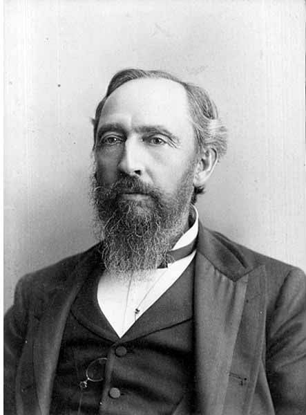
Herbert Raymond in May 1922 ― see S Raymond Street for the Seattle Times article this photo was taken from
This street was named in 1906 as Raymond Avenue, part of Replat Tracts 30 & 31 Sunnyside 5 Acre Tracts, by Herbert R. Raymond (1862–1933) of New Brunswick, Canada, and his wife, Minnie M. Raymond (1874–1947), née Truax, of Massachusetts. In 1907, it and Spencer Avenue became Raymond Street as part of the renaming of streets in Beacon Hill and Rainier Valley, and Grand Avenue, Grand View Avenue, and Sixteenth Street in West Seattle took the name as well. Three years later, when Georgetown was annexed, Raymond Street replaced James Street. (All this information from Rob Ketcherside’s extremely useful searchable table of street name changes.)
Herbert came to Washington as a child, along with his family; Minnie appears to have come later, and the two married in 1895. His eldest brother, George (Herbert was the youngest of eight children), sold shoes in Seattle and was also on the city council and in the territorial, as it then was, legislature. He later moved to Bellingham and was on the city council there in 1912 and 1913, and was mayor for less than two months, in December 1915 and January 1916, his term ending with his sudden death.
Herbert himself was also in the shoe business. As his Seattle Times obituary put it, he was:
Formerly one of the Pacific Northwest’s prominent shoe merchants and leading civic spirits… He had been retired for the past twelve years and had spent most of his time out of doors improving his two-acre residential property which overlooks Lake Washington. Mr. Raymond came to Seattle four years before the Seattle fire and helped fight it. His first shoe store was at First Avenue near Madison Street. He operated in other locations and under other firm names in subsequent years.
Article in the May 7, 1922, Seattle Times, about deer grazing on Herbert Raymond’s lawn and in his orchard. “I believe they came originally from Mercer Island, swimming across to Seward Park. There are no dogs about and the tempting green stuff in my garden coaxed them over the fence…. I don’t see a chance to grow a garden. But the deer are worth it. Their beauty more than repays for their feed.” Download the article as a PDF.
S Raymond Street begins at 51st Place S and goes just over ⅕ of a mile west to 48th Avenue S. It resumes at 44th Avenue S and goes a block west to 42nd Avenue S. There is another short segment that goes 1½ blocks west from Martin Luther King Jr. Way S, and then a longer segment begins at 33rd Avenue S and goes ½ a mile west to Beacon Avenue S, the portion crossing the Chief Sealth Trail being a pathway. A few more segments appear between 24th Avenue S and Swift Avenue S.
SW Raymond Street begins in West Seattle at High Point Drive SW and SW Graham Street and goes 1¼ miles west to 49th Avenue SW.
E Olive Lane begins at Lake Washington Boulevard at the bottom of the E Olive Street stairway and, passing Howell Place, goes around 380 feet east to Lake Washington.
E Olive Street between Melrose Avenue and Bellevue Avenue was renamed E Olive Place sometime between 1912, when it was recorded in the Baist Atlas as E Olive Street, and 1919, the first time it appeared as E Olive Place in The Seattle Times. I could not find any information on the name-change ordinance, and no information appears on King County’s quarter section map. The motivation appears to have been the fact that it meets Bellevue Avenue a half block north of its continuation and was very recently established (1910).
E Olive Street continues the original name of Olive Way east of Bellevue Avenue. As noted in that article, it was named for Olive Julia Bell Stewart (1846–1921), who was five when the Denny Party arrived at Alki Point in 1851.
E Olive Street begins at Bellevue Avenue and goes ⅕ of a mile east to Harvard Avenue. On the other side of Seattle Central College and Cal Anderson Park, it resumes at 11th Avenue and goes another ⅖ of a mile east to 18th Avenue, where it’s interrupted by E Madison Street. Picking up again at 20th Avenue, it goes ⅞ of a mile east to 39th Avenue, where it becomes a short stairway down to Lake Washington Boulevard.
Its initial segment, the block between Melrose Avenue and Bellevue Avenue, was renamed E Olive Place sometime between 1912 and 1919, and its final paved segment, the block between Lake Washington Boulevard and Lake Washington, was renamed E Olive Lane in 1971. As noted in that article, the shoreline street end, for some reason, retained the E Olive Street name.
Triton Drive NW begins at 28th Avenue NW and NW 96th Street and goes around 870 feet northeast to an intersection with NW Esplanade, where it becomes NW Blue Ridge Drive.


