This street, established in 1913 as Sturtevant Place, was named for real estate investor, banker, and antique store owner Cullen Kittredge Sturtevant (1865–1946), who developed a number of tracts in what is now Rainier Beach. Unlike many developers, he didn’t name this street after himself; it was added by the city nearly a decade after he filed Sturtevant’s Plat of Rainier Beach Acre Tracts.
Today, Sturtevant Avenue S begins at Rainier Avenue S between 51st Avenue S and 52nd Avenue S and goes ⅕ of a mile southeast to 52nd Avenue S and S Roxbury Street. Sturtevant Ravine, through which Mapes Creek runs on its way from Kubota Garden to Beer Sheva Park and Lake Washington, lies to its west.
Ad for Sturtevant’s Rainier Beach Lake Front Tracts, The Seattle Times, April 8, 1906
Born and raised in Seattle, Benjamin Donguk Lukoff had his interest in local history kindled at the age of six, when his father bought him settler granddaughter Sophie Frye Bass’s Pig-Tail Days in Old Seattle at the gift shop of the Museum of History and Industry. He studied English, Russian, and linguistics at the University of Washington, and went on to earn his master’s in English linguistics from University College London. His book of rephotography, Seattle Then and Now, was published in 2010. An updated version came out in 2015.
This street was created in 1900 as part of the plat of the Orchard Hill Addition, filed by Martin Dean, Sarah J. Dean, Elizabeth H. Lewis, William H. Lewis, the W.C. Hill Brick Company, and the First National Bank of Seattle. According to Don Sherwood, it was named for John J. Sturgus, “realtor and agent of [the] W.C. Hill Estate” (Hill had died in 1890).
I do find mentions of a John J. Sturgus, associated with the Hill Company or the Hill Estate, in a number of Polk directories. However, it appears a Dr. John J. Sturgus (1859–1907) was also the brother of Hill’s wife, born Alice Bradley Sturgus (1847–1904).
Article in the (Washington, D.C.) Evening Star, September 9, 1890, on the death of W.C. Hill, mentioning Mrs. Hill’s mother (“Mrs. Sturgus”) and brother (Dr. John J. Sturgus).
Given the unlikelihood of two completely different John J. Sturguses being associated with the Hills, I’m going to assume that the physician and real estate man were one and the same, and that the street was given its name either because Dr. Sturgus was Hill’s brother-in-law or because Sturgus was his wife’s maiden name (or both). If the latter, that puts it in the same category as Perkins Lane W, Thorndyke Avenue W, and Keen Way N.
Today, Sturgus Avenue S begins at S Charles Street, just east of the Jose Rizal Bridge, and goes ½ a mile southeast, then south, to S State Street. The right-of-way continues a block further, to the S Grand Street right-of-way, but houses with addresses on that block are accessed by a private alley north of 16th Avenue S.
Born and raised in Seattle, Benjamin Donguk Lukoff had his interest in local history kindled at the age of six, when his father bought him settler granddaughter Sophie Frye Bass’s Pig-Tail Days in Old Seattle at the gift shop of the Museum of History and Industry. He studied English, Russian, and linguistics at the University of Washington, and went on to earn his master’s in English linguistics from University College London. His book of rephotography, Seattle Then and Now, was published in 2010. An updated version came out in 2015.
This North Queen Anne street originates in the 1907 Mayfair Addition to the City of Seattle, filed by the Mayfair Land Company. Don Sherwood notes that “Mayfair is a fashionable district in London, east of Hyde Park,” which was named after the annual May Fair (1686–1764).
Advertisement for the Mayfair Addition in The Seattle Times, March 8, 1907
Mayfair Avenue N begins at Florentia Street between 2nd Avenue N and 3rd Avenue N and goes just over ¼ of a mile south to just past Mayfair Park, where it becomes a private road that goes around 600 feet east to Nob Hill Avenue N. The private section runs through land once owned by the Lorentz family (Lorentz Place N) — in fact, a few members still own houses there.
Born and raised in Seattle, Benjamin Donguk Lukoff had his interest in local history kindled at the age of six, when his father bought him settler granddaughter Sophie Frye Bass’s Pig-Tail Days in Old Seattle at the gift shop of the Museum of History and Industry. He studied English, Russian, and linguistics at the University of Washington, and went on to earn his master’s in English linguistics from University College London. His book of rephotography, Seattle Then and Now, was published in 2010. An updated version came out in 2015.
This street was created in 1890 as part of Hunter’s Lake Union Addition to the City of Seattle by Colonel Morton C. Hunter (1825–1896), Civil War veteran and congressman from Indiana. (His son, Frank, was an insurance and real estate man in Seattle, and it was he who requested the recording of the plat.) Absent any evidence to the contrary, I assume it was named for the tree, though it is the only such street in the plat.
Birch Avenue N begins at Halladay Street just east of Aurora Avenue N and south of Canlis, and goes 300 feet southeast to a dead end.
Born and raised in Seattle, Benjamin Donguk Lukoff had his interest in local history kindled at the age of six, when his father bought him settler granddaughter Sophie Frye Bass’s Pig-Tail Days in Old Seattle at the gift shop of the Museum of History and Industry. He studied English, Russian, and linguistics at the University of Washington, and went on to earn his master’s in English linguistics from University College London. His book of rephotography, Seattle Then and Now, was published in 2010. An updated version came out in 2015.
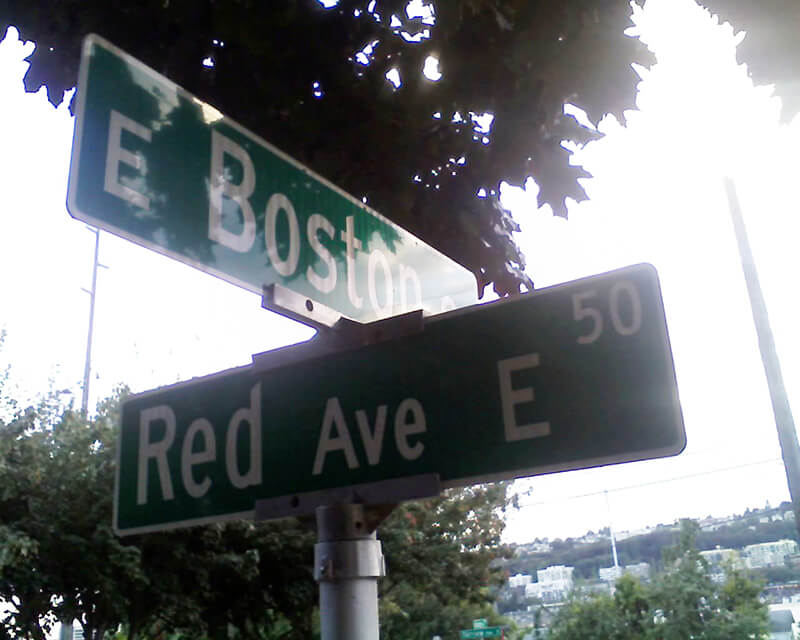
This short street in the Eastlake neighborhood was created in 1887 as part of Greene’s Addition to the City of Seattle, named for and filed by, among others, Roger Sherman Greene (1840–1930) and his wife, Grace Wooster Greene (1833–1917). Instead of naming a street directly after themselves, they dropped an e and named the north–south streets in the plat for (most of) the colors of the rainbow: Red, Orange, Yellow, Green, Indigo, and Violet. Only Red has survived to this day.
Red Avenue E begins at E Boston Street and goes around 150 feet north to a dead end.
Born and raised in Seattle, Benjamin Donguk Lukoff had his interest in local history kindled at the age of six, when his father bought him settler granddaughter Sophie Frye Bass’s Pig-Tail Days in Old Seattle at the gift shop of the Museum of History and Industry. He studied English, Russian, and linguistics at the University of Washington, and went on to earn his master’s in English linguistics from University College London. His book of rephotography, Seattle Then and Now, was published in 2010. An updated version came out in 2015.
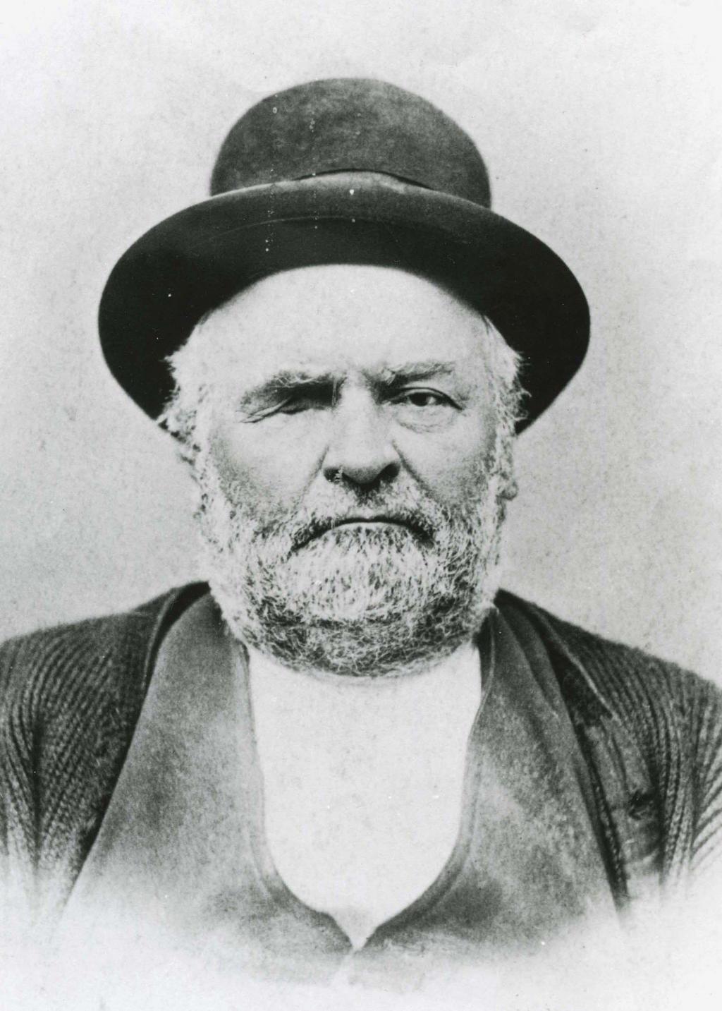
This street is named for Milton Densmore (1839–1908), a Civil War veteran from Chelsea, Vermont, who, according to Clarence Bagley’s History of Seattle from the Earliest Settlement to the Present Time, fought in the Battles of Fairfax Court House, Gettysburg, and Rappahannock Station. He returned to Vermont after the war, then moved to Beloit, Wisconsin, in 1867. Densmore came to Seattle in 1871. Sophie Frye Bass relates in Pig-tail Days in Old Seattle that he started out as “one of the captains of the Linna C. Gray, the stocky barge that carried coal from shore to shore in Lake Union.” In 1875, he opened a grocery, which closed in 1887. Bagley adds that
With various interests of Seattle he was closely associated. He laid the first steel rail for the street car system of Seattle, wooden rails having been used previous to that time. He served for two terms as a member of the city council and exercised his official prerogatives in support of various plans and measures for the general good. He served for seven years as a member of the school board and the cause of education found in him a stalwart champion. Densmore Avenue of Seattle was named in his honor and Seattle in many ways acknowledges her indebtedness to him. He did much toward improving property, built residences and otherwise aided in enhancing the attractiveness of the city and at all times was public spirited and active.
Milton Densmore, from the November 10, 1907, issue of the Seattle Post-Intelligencer. The story was about his reunion with his brother, Jason Densmore, whom he hadn’t seen in over four decades, since the Civil War ended (Jason was likewise a Union soldier from Vermont).
Densmore Avenue N begins at N Northlake Way, just north of Gas Works Park. It then goes ¾ of a mile north to the Wallingford Playfield at N 42nd Street. Resuming a block north, it goes a further ⅖ of a mile to N 50th Street. It picks up again at the north end of Green Lake, where Green Lake Drive N splits into W Green Lake Drive N and E Green Lake Drive N, and goes ⅗ of a mile to Cascadia Elementary School at N 90th Street. Densmore resumes at N 92nd Street and goes another ⅗ of a mile, past Licton Springs Park, to Mineral Springs Park at N 105th Street. It picks up again just north of N Northgate Way for a couple blocks before being stopped by Evergreen–Washelli Cemetery and UW Medical Center – Northwest. After a short segment north of the hospital, it then forms part of the ring arterial around Haller Lake, going ⅓ of a mile from N 122nd Street to N 128th Street, and finishes up with a ½-mile-long segment from Ingraham High School at N 135th Street to the city limits at N 145th Street. (As with many other North Seattle avenues, the name continues on into Shoreline; its northernmost appearance is between N 202nd Place and N 203rd Place, just south of the King–Snohomish county line at N 205th Street.)
Born and raised in Seattle, Benjamin Donguk Lukoff had his interest in local history kindled at the age of six, when his father bought him settler granddaughter Sophie Frye Bass’s Pig-Tail Days in Old Seattle at the gift shop of the Museum of History and Industry. He studied English, Russian, and linguistics at the University of Washington, and went on to earn his master’s in English linguistics from University College London. His book of rephotography, Seattle Then and Now, was published in 2010. An updated version came out in 2015.
Matilda and Nelson Chilberg. Her photo is from the July 17, 1927, issue of the The Seattle Times; his is from the December 15, 1928, issue of the Seattle Post-Intelligencer.
Chilberg Avenue SW begins at 59th Avenue SW and SW Carroll Street and goes ⅕ of a mile southeast to SW Genessee Street just east of Beach Drive SW at the Emma Schmitz Memorial Overlook and Me-Kwa-Mooks Park.
Born and raised in Seattle, Benjamin Donguk Lukoff had his interest in local history kindled at the age of six, when his father bought him settler granddaughter Sophie Frye Bass’s Pig-Tail Days in Old Seattle at the gift shop of the Museum of History and Industry. He studied English, Russian, and linguistics at the University of Washington, and went on to earn his master’s in English linguistics from University College London. His book of rephotography, Seattle Then and Now, was published in 2010. An updated version came out in 2015.
I enjoy writing posts on streets like W Commodore Way (I believe I am the first to have accurately identified its namesake), Division Avenue NW (I show that, even though it doesn’t divide anything from anything else today, it once served as Ballard’s eastern city limit for a few blocks), Loyal Avenue NW (I discover that it’s named not for the concept of loyalty, but for a baby girl whose first name was Loyal), and sluʔwiɫ (the University of Washington’s new Lushootseed-language name for Whitman Court). But sometimes I just like knocking something out quickly (I’m looking at you, W View Place and View Avenue NW). Sunset Avenue SW is another one of those. It originated in the 1888 First Plat of West Seattle by the West Seattle Land and Improvement Company, and the name simply refers to the street’s western view of Puget Sound; Vashon, Blake, and Bainbridge Islands; the Kitsap Peninsula; and the Olympic Mountains.
Sunset Avenue SW begins as a stairway at California Avenue SW, just across the street from Hamilton Viewpoint Park. Once the roadway begins up the hill, it goes ⅘ of a mile southwest to a dead end at the College Street Ravine southwest of 50th Avenue SW.
Born and raised in Seattle, Benjamin Donguk Lukoff had his interest in local history kindled at the age of six, when his father bought him settler granddaughter Sophie Frye Bass’s Pig-Tail Days in Old Seattle at the gift shop of the Museum of History and Industry. He studied English, Russian, and linguistics at the University of Washington, and went on to earn his master’s in English linguistics from University College London. His book of rephotography, Seattle Then and Now, was published in 2010. An updated version came out in 2015.
Born and raised in Seattle, Benjamin Donguk Lukoff had his interest in local history kindled at the age of six, when his father bought him settler granddaughter Sophie Frye Bass’s Pig-Tail Days in Old Seattle at the gift shop of the Museum of History and Industry. He studied English, Russian, and linguistics at the University of Washington, and went on to earn his master’s in English linguistics from University College London. His book of rephotography, Seattle Then and Now, was published in 2010. An updated version came out in 2015.
Elliott Avenue begins at Western Avenue and Lenora Street and goes 2⅕ miles northwest to halfway between W Galer Street and W Garfield Street, where it becomes 15th Avenue W.
Looking south down Elliott Avenue W at W Mercer Place, August 1921. Courtesy of the Seattle Municipal Archives, Identifier 1862
Born and raised in Seattle, Benjamin Donguk Lukoff had his interest in local history kindled at the age of six, when his father bought him settler granddaughter Sophie Frye Bass’s Pig-Tail Days in Old Seattle at the gift shop of the Museum of History and Industry. He studied English, Russian, and linguistics at the University of Washington, and went on to earn his master’s in English linguistics from University College London. His book of rephotography, Seattle Then and Now, was published in 2010. An updated version came out in 2015.
This street is named after the city of Renton, Washington, located southeast of Seattle at the southern end of Lake Washington. The city was itself named after Captain William Renton (1818–1891). Born in Nova Scotia, he came to the Puget Sound area in the mid-1850s and founded the Port Blakely mill on Bainbridge Island in 1864. Erasmus Smithers founded the Renton Coal Company with Captain Renton’s financial backing in 1873 and filed the first town plat in 1875.
William Renton, 1818 – 1891
A Renton Avenue existed in Seattle before this one, but not for very long — it was established in 1894 from streets on Capitol Hill “now called in various portions thereof Black Street, Joy Street, Renton Avenue and Eighteenth Avenue.” (Part of this area had been platted by Captain Renton, and was known at the time as Renton Hill.) It was changed the next year to 16th Avenue as part of the Great Renaming.
The current Renton Avenue was established in 1907 from what had been an old county road, Simpson Avenue, Hillman Boulevard, and a number of unnamed streets. According to the North Rainier Valley Historic Context Statement, this is quite an old route:
King County Road No. 1 ran east down from Beacon Hill at about the location of today’s Cheasty Boulevard, and then followed the approximate line of today’s Renton Avenue South to Renton. It also had been an earlier Indian trail route. Renton Avenue South is the remnant of this original county road to Renton. While portions of this road still exist, some are now incorporated into Martin Luther King, Jr. Way.
Today, Renton Avenue S begins at Martin Luther King Jr. Way S just south of S Walden Street and goes ¾ of a mile southeast to 33rd Avenue S just north of S Alaska Street. It resumes at 35th Avenue S just south of S Hudson Street and goes another ½ mile to S Juneau Street west of 39th Avenue S. It then starts up again at Martin Luther King Jr. Way S and S Webster Street and goes nearly 3 miles to the city limits south of S 116th Place. (Renton Avenue continues beyond there another 2 miles to — of course — Renton, where at 90th Avenue S and Taylor Avenue NW it becomes the Renton Avenue Extension and goes a further ⅛ of a mile to Rainier Avenue S and Airport Way.)
Born and raised in Seattle, Benjamin Donguk Lukoff had his interest in local history kindled at the age of six, when his father bought him settler granddaughter Sophie Frye Bass’s Pig-Tail Days in Old Seattle at the gift shop of the Museum of History and Industry. He studied English, Russian, and linguistics at the University of Washington, and went on to earn his master’s in English linguistics from University College London. His book of rephotography, Seattle Then and Now, was published in 2010. An updated version came out in 2015.
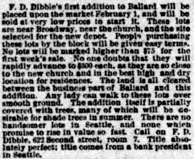
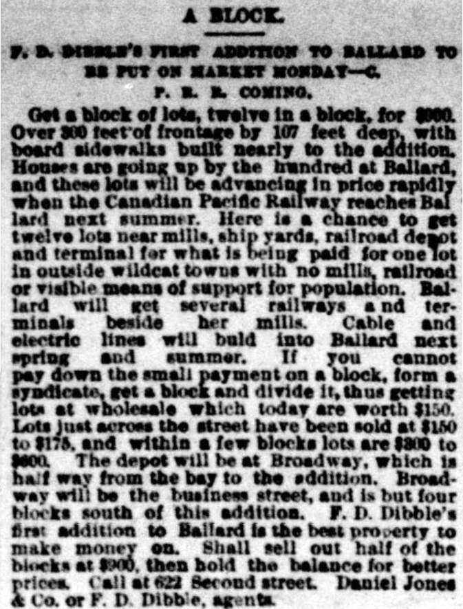
This street was created in 1890 as part of F.D. Dibble’s First Addition to Ballard, which had just incorporated as a city that year, and would be annexed to Seattle 17 years later. It would, therefore, seem to be named after F.D. Dibble. But who was he? And who was J. Albert Jackson, who filed the plat?
Jackson first. The December 2, 1912, issue of The Sacramento Union refers to him as former vice president of the Washington-Alaska Bank of Nevada (based in Fairbanks). He was charged with falsifying the failed bank’s books and aiding and abetting its receiver, Frank W. Hawkins, in embezzlement. So much for his good name, which was used in one of the advertisements for the addition: “Title absolutely perfect; title comes from a bank president in Seattle.”
Advertisements for F.D. Dibble’s First Addition to Ballard in the Seattle Post-Intelligencer, January 27 and 31, 1890. “These lots are near Broadway [NW Market Street], near the church, and the site selected for the new depot [37th Place NW south of NW 57th Street].” “Houses are going up by the hundred at Ballard, and these lots will be advancing in price rapidly when the Canadian Pacific Railway reaches Ballard next summer. Here is a chance to get twelve lots near mills, ship yards, railroad depot and terminal for what is being paid for one lot in outside wildcat towns with no mills, railroad or visible means of support for population.”
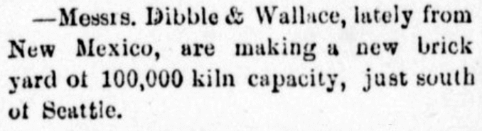
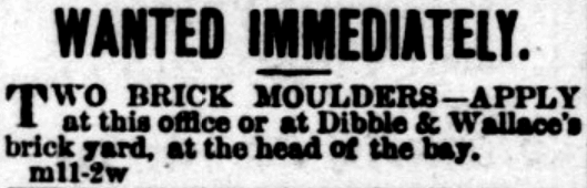
I was able to find out even less about F.D. Dibble. He appears to have been associated with Daniel Jones & Co., who were involved in the development of Mount Baker Park (see Hunter Boulevard S for more on Jones). But that’s it. I was able to find two mentions of Dibble & Wallace, a brick manufacturing company, which opened in 1882, but no first names of either proprietor. Dibble may have been F.D., or a relative — it’s impossible to say.
Advertisements for the brick manufacturing company Dibble & Wallace in the Northwest Enterprise (Anacortes), April 8, and the Seattle Post-Intelligencer, May 21, 1882
I also came across a book, Prairie Poems and Others, written by an F.D. Dibble and published in 1900. There is no biographical information included, but this Dibble plainly had been to Washington: among the many poems are “Lake Pend d’Oreille, Washington,” “Mt. Rainier,” and “Rainy Days in Seattle.” Could this have been the real estate man? Again — impossible to say.
We must leave it at this, then: Dibble Avenue NW was named for F.D. Dibble… full stop.
Today, Dibble Avenue NW begins at NW 65th Street and goes 1½ miles north to NW 95th Street. It begins again on the other side of Holman Road NW at NW 97th Street and goes ⅓ of a mile north to NW 105th Street.
Born and raised in Seattle, Benjamin Donguk Lukoff had his interest in local history kindled at the age of six, when his father bought him settler granddaughter Sophie Frye Bass’s Pig-Tail Days in Old Seattle at the gift shop of the Museum of History and Industry. He studied English, Russian, and linguistics at the University of Washington, and went on to earn his master’s in English linguistics from University College London. His book of rephotography, Seattle Then and Now, was published in 2010. An updated version came out in 2015.
The settlement at Alki Point established by the Denny Party in 1851 was originally named New York. By a process that is not entirely clear, the name became New York–Alki, and then just Alki. Alki means ‘by and by’ or ‘someday’ in Chinook Jargon, the implication being that the settlement might rival New York… someday. Charles C. Terry officially applied the Alki name to the town plat he filed in 1853, and the point, street, and neighborhood were all named after it.
In the introduction to her 1937 book, Pig-Tail Days in Old Seattle, Sophie Frye Bass writes:
Please everyone, pronounce Alki as the Indians did, as if it were spelled “Alkey.”
Hardly anyone does this anymore — in fact I don’t think I’ve ever heard someone say /ælkiː/ in all seriousness when talking about West Seattle. /ælkaɪ/ is by far the preferred pronunciation, as shown by this informal Twitter poll I ran:
Note: On July 10, 2024, I began converting embedded tweets on this website to screenshots because of issues with how they were integrating with WordPress, which began not too long after Elon Musk purchased Twitter and changed its name to X.
Louis Miranda: Suqmish Elder teaches Chinook Wawa on YouTubeBirthplace of Seattle monument, 1926. Originally dedicated in 1905 on the 54th anniversary of the landing of the Denny Party at Alki Point, it reads “At this place on 13 November 1851 there landed from the Schooner Exact Captain Folger [and] the little colony which developed into the City of Seattle.” It was rededicated, with a new foundation, on September 4, 1926 (likely the date of this photograph). A stone from near Plymouth Rock, Massachusetts, was put in the foundation, and the new plaque reads “From Plymouth Rock to Alki Point: Honoring pioneers on the American shores of the Atlantic and Pacific Oceans, the above stone was brought from Plymouth Rock by the First Transcontinental Motorized Caravan, managed by James H. Brown, and endorsed by the American Automobile Association. This tablet was furnished by the Automobile Club of Washington. The unveiling ceremonies on September 4, 1926, was participated in by officers and citizens of. the City of Seattle, the County of King and the State of Washington.” Courtesy of the Seattle Municipal Archives, Identifier 46980
Born and raised in Seattle, Benjamin Donguk Lukoff had his interest in local history kindled at the age of six, when his father bought him settler granddaughter Sophie Frye Bass’s Pig-Tail Days in Old Seattle at the gift shop of the Museum of History and Industry. He studied English, Russian, and linguistics at the University of Washington, and went on to earn his master’s in English linguistics from University College London. His book of rephotography, Seattle Then and Now, was published in 2010. An updated version came out in 2015.
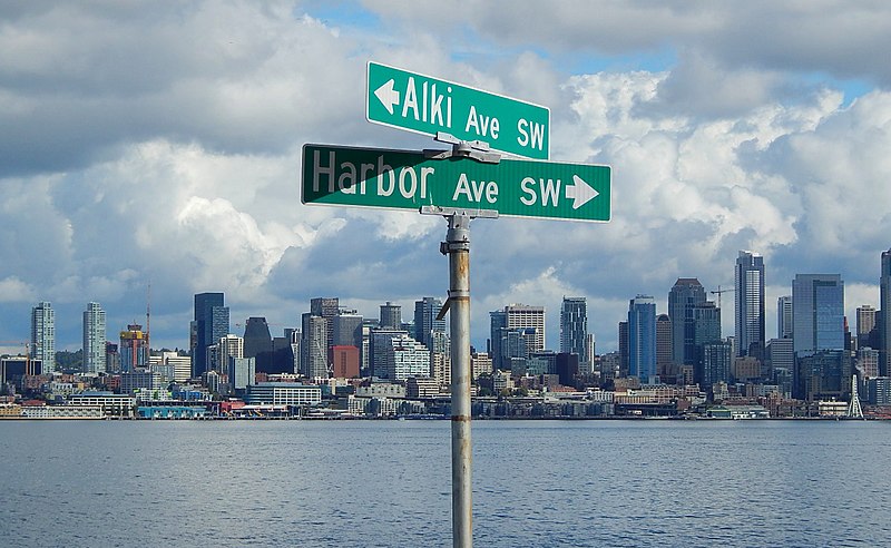
As noted in Alaskan Way, Harbor Avenue SW was once part of Railroad Avenue. When the Elliott Bay tidelands were platted in 1895, Railroad Avenue stretched from (using current landmarks) the Magnolia Bridge along the waterfront to the Industrial District, then across Harbor Island to West Seattle, ending southwest of Duwamish Head. In 1907 the West Seattle portion was renamed Alki Avenue, and sometime between 1912 and 1920 it was given its current name.
Looking northwest up what is now Harbor Avenue SW toward Duwamish Head, April 1902
Today, Harbor Avenue SW begins at SW Avalon Way and SW Spokane Street at the west end of the West Seattle Bridge and goes 1¾ miles northwest to Duwamish Head, where it becomes Alki Avenue SW.
Born and raised in Seattle, Benjamin Donguk Lukoff had his interest in local history kindled at the age of six, when his father bought him settler granddaughter Sophie Frye Bass’s Pig-Tail Days in Old Seattle at the gift shop of the Museum of History and Industry. He studied English, Russian, and linguistics at the University of Washington, and went on to earn his master’s in English linguistics from University College London. His book of rephotography, Seattle Then and Now, was published in 2010. An updated version came out in 2015.
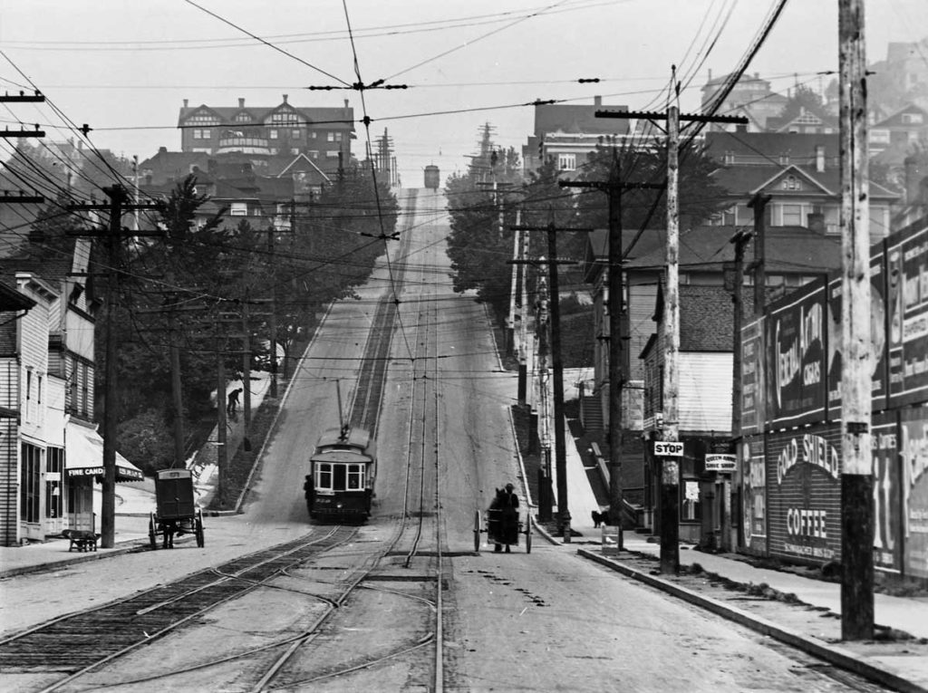
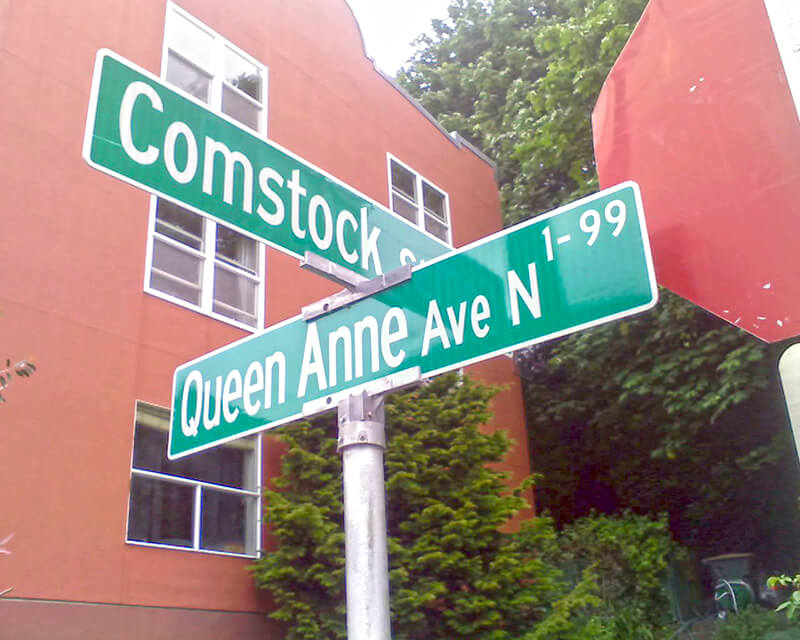
Originally Temperance Street and Villard Avenue, Queen Anne Avenue N was given its current name in 1895 as part of the Great Renaming. It was named after Queen Anne Hill and the Queen Anne neighborhood. Originally called Eden Hill or Galer Hill, they were themselves renamed after the Queen Anne architectural style that became popular in the 1880s.
Looking north up the Counterbalance (Queen Anne Avenue N), 1910
Queen Anne Avenue begins at Western Avenue, less than 100 feet south of Denny Way, and becomes Queen Anne Avenue N as it crosses Denny. From there it goes 2⅕ miles north to Bertona Street and the Ship Canal Trail.
Born and raised in Seattle, Benjamin Donguk Lukoff had his interest in local history kindled at the age of six, when his father bought him settler granddaughter Sophie Frye Bass’s Pig-Tail Days in Old Seattle at the gift shop of the Museum of History and Industry. He studied English, Russian, and linguistics at the University of Washington, and went on to earn his master’s in English linguistics from University College London. His book of rephotography, Seattle Then and Now, was published in 2010. An updated version came out in 2015.
In the early 1870s, the Denny and Mercer families gradually began to systematically subdivide their large land holdings on the south and east slopes of Queen Anne Hill. When a severe windstorm blew down thousands of trees in the north district in 1875, views opened up and land seekers turned their attentions beyond Belltown. Real estate speculators new to the territory arrived and began to buy up property on the crest of Queen Anne Hill. Some of these speculators also became developers, such as George Kinnear, or builder-developers, such as Isaac Bigelow.
Bigelow Avenue N forms a major part of Queen Anne Boulevard, the scenic loop atop Queen Anne Hill. It begins at 2nd Avenue N and Prospect Street and goes 9⁄10 of a mile to Wheeler Street between 4th Avenue N and 5th Avenue N.
Part of the street is lined with chestnut trees — not horse chestnuts, but the edible variety, specifically the Chinese chestnut, Castanea mollissima, according to the city’s records. My family (my mother was Korean) never foraged here, though we have done so elsewhere in the area, both for chestnuts and fiddlehead ferns. But plenty of others have, and continue to do so, as these articles show:
It should be noted that since Bigelow Avenue N is part of Queen Anne Boulevard, the trees belong to the parks department, not to the neighbors. As with similar park boulevards in town, neighbors’ yards often encroach on the public right-of-way.
Born and raised in Seattle, Benjamin Donguk Lukoff had his interest in local history kindled at the age of six, when his father bought him settler granddaughter Sophie Frye Bass’s Pig-Tail Days in Old Seattle at the gift shop of the Museum of History and Industry. He studied English, Russian, and linguistics at the University of Washington, and went on to earn his master’s in English linguistics from University College London. His book of rephotography, Seattle Then and Now, was published in 2010. An updated version came out in 2015.
This street was named for Alonzo Hamblet (1863–1937), son of Eli (1820–1905) and Mary Booth Hamblet (1840–1905), namesake of Mary Avenue NW. According to an article in the November 19, 1937 issue of The Seattle Times, the Hamblets had their homestead where Ballard High School is today. Alonzo was one of the men behind the West Coast Improvement Company that developed Ballard (then known as Gilman Park).
Alonzo Avenue NW begins at NW 67th Street just north of the high school and goes ⅖ of a mile to NW 75th Street.
Born and raised in Seattle, Benjamin Donguk Lukoff had his interest in local history kindled at the age of six, when his father bought him settler granddaughter Sophie Frye Bass’s Pig-Tail Days in Old Seattle at the gift shop of the Museum of History and Industry. He studied English, Russian, and linguistics at the University of Washington, and went on to earn his master’s in English linguistics from University College London. His book of rephotography, Seattle Then and Now, was published in 2010. An updated version came out in 2015.
This street was named for Mary Booth Hamblet (1840–1905), wife of Eli (1820–1905) and mother of Alonzo (1863–1937), namesake of Alonzo Avenue NW. The Hamblets were early Ballard settlers, and according to an article in the November 19, 1937 issue of The Seattle Times had their homestead where Ballard High School is today.
Mary Avenue NW begins at NW 67th Street just north of the high school and goes nearly 2 miles to the NW 105th Street right-of-way, where it becomes a trail leading to Carkeek Park. As I wrote in NW Blue Ridge Drive,
Ten or so years ago I saw a Private Property sign at the trailhead, put up by the Blue Ridge Club, but it was gone the next time I visited — I can’t remember if I complained or someone else did. (The woods are private, but the trail is Mary Avenue NW right-of-way.) This wasn’t in the original plat, but according to an old Flickr chat I had with Andreas “Severinus” Breuer, “there was apparently a WPA project approved to install a 30′-wide gravel road between 100th and 110th (apparently now NW Carkeek Park Road).… I imagine the ravine would look quite different if a 30′ gravel road had been put in, so presumably this plan wasn’t carried out. But a 1940 engineering map shows a surveyed ROW from 105th to the Carkeek border, and in Carkeek there seems to be a route that follows the WPA route (Clay Pit Trail > Hillside Trail > Brick Road Trail > Road). Perhaps the trail that exists today was made by the original surveyors or by WPA men?”
Born and raised in Seattle, Benjamin Donguk Lukoff had his interest in local history kindled at the age of six, when his father bought him settler granddaughter Sophie Frye Bass’s Pig-Tail Days in Old Seattle at the gift shop of the Museum of History and Industry. He studied English, Russian, and linguistics at the University of Washington, and went on to earn his master’s in English linguistics from University College London. His book of rephotography, Seattle Then and Now, was published in 2010. An updated version came out in 2015.
This street was created in 1895 as part of the plat of Seattle’s tide lands. As Seattle expanded to the south, it became obvious that Commercial Street (1st Avenue S) would not be the westernmost street east of Elliott Bay. Fortunately, instead of using zero or negative numbers, they went with states: the first street west of 1st was named Utah, and the next, Colorado. (Some perpendicular streets were named Alaska, Vermont, Connecticut, Texas, Massachusetts, etc. There doesn’t appear to have been any particular order.)
Colorado Avenue S begins at S Royal Brougham Way and goes ⅓ of a mile south to S Massachusetts Street. It begins again on the back side of the Starbucks Center and goes ⅘ of a mile to just south of S Spokane Street, and its final segment begins just north of Diagonal Avenue S and goes ⅔ of a mile to S Dawson Street.
Born and raised in Seattle, Benjamin Donguk Lukoff had his interest in local history kindled at the age of six, when his father bought him settler granddaughter Sophie Frye Bass’s Pig-Tail Days in Old Seattle at the gift shop of the Museum of History and Industry. He studied English, Russian, and linguistics at the University of Washington, and went on to earn his master’s in English linguistics from University College London. His book of rephotography, Seattle Then and Now, was published in 2010. An updated version came out in 2015.
This street was created in 1895 as part of the Seattle Tide Lands plat (in full, Seattle Tide Lands as Surveyed and Platted by the Board of Appraisers of Tide and Shore Lands for King County, Washington). Streets were laid out from the northern tip of Magnolia (see W Semple Street) to West Seattle, but only the land southeast of Magnolia down to the Duwamish River was ultimately filled and developed.* (Magnolia’s tidelands were intended to become industrial land as part of the Bogue Plan, but this was rejected, and they have remained untouched west of the Elliott Bay Marina.)
As can be seen in the portion of the plat map reproduced below, the streets perpendicular to the shoreline in southwest Magnolia were named alphabetically after various cities in the United States. (Northwest of here, they were simply given letters of the alphabet, beginning with A and making it as far as O.) The namers began with Allegheny (Pennsylvania), and continued with Bangor (Maine), Chattanooga (Tennessee), Duluth (Minnesota), Erie (Pennsylvania), Fresno (California), Galveston (Texas), Hartford (Connecticut), Ithaca (New York), and our subject, Joliet (Illinois), before switching to yet another series.
Born and raised in Seattle, Benjamin Donguk Lukoff had his interest in local history kindled at the age of six, when his father bought him settler granddaughter Sophie Frye Bass’s Pig-Tail Days in Old Seattle at the gift shop of the Museum of History and Industry. He studied English, Russian, and linguistics at the University of Washington, and went on to earn his master’s in English linguistics from University College London. His book of rephotography, Seattle Then and Now, was published in 2010. An updated version came out in 2015.


.jpg)