Terry Avenue

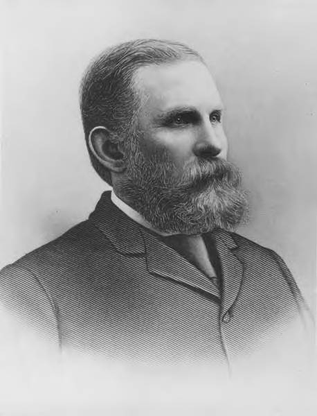
This street is named after Charles Carroll Terry (1830–1867), one of the members, along with his older brother, Lee, of the Denny Party that landed at Alki Point in November 1851. Shortly after the landing, he opened the first store in King County. Lee had made a land claim in Alki a few months earlier, but went home to New York the next year; Charles remained, even after most of the other settlers left for what is now Pioneer Square. It seems he finally moved north in 1857, trading his Alki land for that of David Swinson “Doc” Maynard in Pioneer Square. He died 10 years later, according to this biography, of tuberculosis. (Whether or not he and his brother were responsible for naming the Alki Point settlement New York, which became New York–Alki [the latter word meaning ‘by and by’ or ‘someday’ in Chinook Jargon] and then just Alki, is unclear, although he did officially apply the Alki name to the town plat he filed in 1853.)

In 1855, he, along with Edward Lander, bought Carson Boren’s downtown land claim for $500; he and Lander donated two acres to form the first campus of the University of Washington, which opened in 1861. (He named one of his sons, born in 1862, Edward Lander Terry.) His name also appears on Terry Hall, a UW dormitory on NE Campus Parkway.
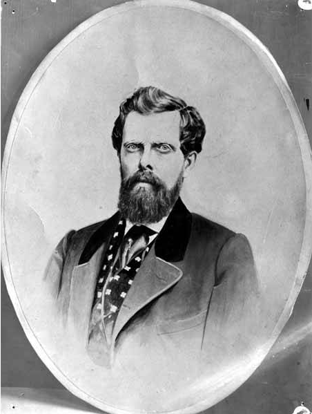
Charles C. Terry
Charles Carroll Terry

Terry Avenue begins at Alder Street on First Hill and goes ½ a mile to Spring Street, where it is blocked by Virginia Mason Hospital. Resuming at Seneca Street, it goes ⅕ of a mile to Pike Street. On the other side of Interstate 5 and the Washington State Convention Center, it begins again at Howell Street and goes ⅘ of a mile to Valley Street and Lake Union Park, becoming Terry Avenue N as it crosses Denny Way. Amazon.com’s headquarters are at 410 Terry Avenue N, between Harrison Street and Republican Street.

Minor Avenue

This street is named for Dr. Thomas Taylor Minor (1844–1889), who came to Seattle in 1883 from Port Townsend, where he had lived since 1868 and whose mayor he had been in 1880 and 1881. He was one of the founders of the Seattle, Lake Shore and Eastern Railway in 1885 and became mayor of Seattle from 1887 to 1889. He drowned off Whidbey Island while on a duck-hunting trip on December 2, 1889. The other fatalities were George Morris Haller, brother of Theodore Haller for whom Haller Lake is named, and his brother-in-law, Lewis Cox.

Thomas Taylor Minor
Dr. Thomas Taylor Minor

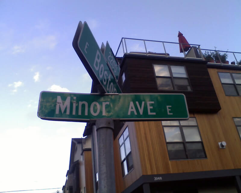
Minor Avenue begins at Broadway just north of Jefferson Street and goes ⅔ of a mile northwest to Pine Street. Resuming on the other side of Interstate 5 at Olive Way, it goes another ⅔ of a mile northwest, then north, to Mercer Street, having become Minor Avenue N north of Denny Way. After a two-block stretch from Roy Street to Aloha Street, it appears again as Minor Avenue E at E Newton Street, and goes nearly ½ a mile to its end at E Roanoke Street.

Sign at corner of E Boston Street and Minor Avenue E, September 1, 2010
Signs at corner of E Boston Street and Minor Avenue E, September 1, 2010. Photograph by Benjamin Lukoff. Copyright © 2010 Benjamin Lukoff. All rights reserved.

Boren Avenue

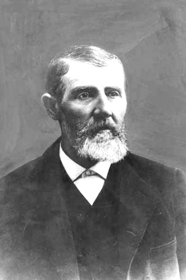
This street was named for Carson Dobbins Boren (1824–1912), a member of the Denny Party that landed at Alki Point in November 1851. His sisters Mary Ann (1822–1910) and Louisa (1827–1916) married brothers Arthur (1822–1899) and David Denny (1832–1903) in 1843 and 1853, respectively. These weren’t the only Boren–Denny connections, either: his mother, Sarah Latimer Boren (1805–1888), who had been widowed in 1827, married John Denny (1793–1875) — Arthur and David’s father — in 1848. (Their mother, also named Sarah, had died in 1841.)

Boren is said to have built the first cabin in Seattle, at what is now 2nd Avenue and Cherry Street, in April 1852. He was elected King County’s first sheriff the same year. Boren’s land claim of 320 acres covered what is today a rectangle approximately bounded by (going clockwise) Yesler Way, 15th Avenue, E Cherry Street and its projection west, and Western Avenue and its projection north, but he sold it for $500 to Charles Terry and Edward Lander in 1855.*

* “Its projection” is necessary here because of Boren and Arthur Denny’s decision to have their street grid follow the shoreline, while “Doc” Maynard preferred his to follow the cardinal directions; Maynard’s grid eventually extended through the entire city and, indeed, county. (See “Seattle’s first streets.”) The actual southern boundary is a bit north of Yesler Way since both Boren and Maynard adjusted their initial claims to give Henry Yesler land to build and supply his sawmill.

Why Boren sold his land isn’t entirely clear. Sophie Frye Bass writes in Pig-Tail Days in Old Seattle that he sold it “early at a great sacrifice and became a roamer and, therefore, did not share in the up-building of the town”; her sister, Roberta Frye Watt, is indirectly quoted by Junius Rochester thus: “Carson had an unhappy home life. This compelled him to move deeper and deeper into the forest; to hunt and dream; and to shed most of his possessions.” Indeed, he and his wife, Mary Ann, divorced in 1861.

Carson Dobbins Boren, photographer and date unknown
Carson Dobbins Boren

Today, Boren Avenue S begins at 14th Avenue S, Rainier Avenue S, and S Jackson Street, and goes 2⅕ miles north to Valley Street and Lake Union Park, becoming Boren Avenue as it crosses Yesler Way and Boren Avenue N as it crosses Denny Way. It is one of the few north–south streets in Seattle to have three directional designations.

Pike Street

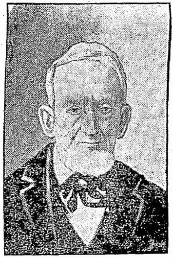
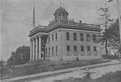
Pike Street first appears in the Plat of an Addition to the Town of Seattle as Laid Out by Arthur A. Denny, filed on April 5, 1869. It was named by Denny for John Henry Pike (1814–1903), best known for being the architect and builder of the original Territorial University of Washington in 1861. This article by Rob Ketcherside is the most comprehensive information available online about Pike. “Early Pikes in Seattle,” by Stuart Pike, is also worth a read. (Also of note: Pike’s son, Harvey Lake Pike [1842–1897], was the first person to try to connect Lake Washington’s Union Bay to Lake Union’s Portage Bay by a canal. This was unsuccessful, but he did end up platting the land in 1869 as Union City. His E North Street [north of the proposed canal] survives to this day.)

John Pike, from his obituary in the November 22, 1903, issue of The Seattle Times

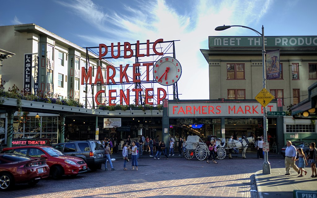
In the original plat, Pike Street (as well as Union and Pine Streets) begins at Front Street — today’s 1st Avenue — but today it begins on the Elliott Bay waterfront at Alaskan Way as the Pike Street Hillclimb. Pike Street proper begins at Pike Place (home of the eponymous market) and Post Alley (underneath the Market Theater sign), both shown below, and makes it a full 1⅔ miles to just past 18th Avenue in the Central District before being interrupted. It then resurfaces at 23rd Avenue and goes another ⅘ of a mile to Grand Avenue in Madrona, a few blocks east of Lake Washington.

Pike Place Market entrance, corner of Pike Street and Pike Place, 2012
Pike Place Market entrance, corner of Pike Street and Pike Place, 2012. Photograph by kissmykumbaya, Wikimedia Commons (public domain)

University Street

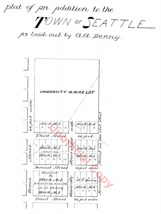
University Street was established as part of the Plat of an Addition to the Town of Seattle as Laid Out by A.A. Denny on November 16, 1861. It was named for the Territorial University of Washington, which had opened 12 days earlier on a 10-acre site atop “Denny’s Knoll.”

Plat of an Addition to the Town of Seattle as Laid Out by A.A. Denny, November 16, 1861
Territorial University on opening day, showing south and west sides of main building, November 4, 1861
Territorial University of Washington on opening day, November 4, 1861

Even though the University of Washington moved to its current location on Portage and Union Bays in 1895, the name was not changed. Nor did the university relinquish the land, though not for lack of trying. This turns out to have been fortunate. The UW owns the Metropolitan Tract to this day, and it earned $25 million in rent on the property during fiscal year 2020 alone.

The street, which originally ran from Front Street (now 1st Avenue) to the university campus, just northeast of 3rd Avenue, today begins at Alaskan Way on the Elliott Bay waterfront, and makes it just one block, to Western Avenue, before it becomes the Harbor Steps. From 1st Avenue, it’s about a third of a mile to 7th Avenue, where University Street is blocked by Interstate 5. It resumes at 9th Avenue and goes for another third of a mile to Boylston Avenue.

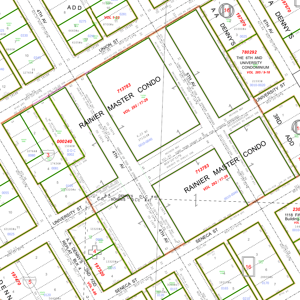
Portion of King County quarter section maps covering Metropolitan Tract

Incidentally, you’ll notice in the map above that 4th and 5th Avenues between Seneca and Union Streets, as well as University Street between 4th and 5th Avenues, plus half a block on either end, are marked private way subject to public use — long term grant of use for street purposes. This fact — that the University of Washington still owns all the land within the Metropolitan Tract and never formally dedicated those streets to the public — was something I never knew until I started taking close looks at King County’s quarter section maps as part of my local history research. It might seem an academic distinction, but as The Seattle Times reported in 2015, there are very real financial consequences.

In 2008… the UW wanted the city to interpret the tract as one undivided lot, streets and all. That novel argument would benefit the UW in calculating the development footprint, or base.… The bigger the base, the logic went, the more square footage a developer could build before triggering affordable-housing fees under the city’s formula.… The university held a heavy hammer in negotiations. Because the UW owned development rights for the land under Fifth Avenue and University Street, it could make the city compensate it, one way or another, for using those streets.

Madison Street

Madison Street — another of Seattle’s “first streets” — was named for James Madison, president of the United States from 1809 to 1817. It is the only street in town that stretches, uninterrupted, from the salt water of Elliott Bay and Puget Sound to the fresh water of Lake Washington.

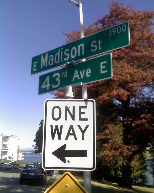
Originating as the McGilvra Road in 1861, Madison Street begins on the Elliott Bay waterfront at Alaskan Way and ends 3¾ miles northeast of there at a small fishing pier, just east of 43rd Avenue E and north of Madison Park Beach. Apart from a slight bend to the northeast at 22nd Avenue, it is as straight as an arrow from beginning to end.

Signs at corner of E Madison Street and 43rd Avenue E, October 11, 2009
Signs at corner of E Madison Street and 43rd Avenue E, October 11, 2009. Photograph by Benjamin Lukoff. Copyright © 2009 Benjamin Lukoff. All rights reserved.

Spring Street

Spring Street was another of Seattle’s “first streets.” Sophie Frye Bass writes in Pig-Tail Days in Old Seattle:

Where springs of clear water bubbled from the earth and the beach was sandy and free from rocks, there the Indians camped. Such a choice spot was Tzee-tzee-lal-litch [dzidzəlalič], which Arthur Denny called Spring Street.

Spring Street begins at Alaskan Way and runs nearly a mile, to Harvard Avenue, before it is interrupted. A few more segments run through the Central District and Madrona. The last is from 38th Avenue to Grand Avenue, at which point it continues to Lake Washington Boulevard as a footpath and stairway.

Cherry Street

Cherry Street was among the first streets platted in Seattle on May 23, 1853. Sophie Frye Bass, author of Pig-Tail Days in Old Seattle, writes:

I choose to think that Cherry Street is named for the little town of Cherry Grove, Illinois — Mother’s birthplace — where the Dennys started on their long journey over the Oregon Trail.

“Mother,” in this case, refers to Louisa Catherine Denny Frye, one of three children of Arthur Armstrong Denny and Mary Ann Boren Denny of the Denny Party. She was 7 years old when they landed at Alki Point in November 1851.

In 2006, Hunter Brown wrote a People’s History essay for HistoryLink, “Finding Cherry Grove,” detailing his efforts to locate Cherry Grove, whose name was later changed to Cedar Township. The nearest town today is called Abingdon.

Bass began her Pig-Tail Days piece on Cherry Street by calling it “another up-and-up street… with no interferences. It begins at First Avenue, goes east and ends at Thirty-seventh avenue.” This is no longer quite the case because of a very small gap at the south end of the Seattle University campus. Today, Cherry begins at 1st Avenue and ends a block east of Broadway. It starts up again a couple hundred feet to the east as a continuation of the James Street/E James Way arterial, and then does go on to 37th Avenue in Madrona. All told it is 2⅓ miles long.

Marion Street

Marion Street, like James Street, was one of the first streets platted in Seattle on May 23, 1853. It, too, was named by Arthur Armstrong Denny after his younger brother, James Marion Denny (1824–1854). 

Marion Street runs ⅖ of a mile from Alaskan Way to 6th Avenue, where it is interrupted by Interstate 5. It picks up again at 7th Avenue and runs about the same distance to Broadway, where the Seattle University campus begins. East of there it runs in sections of varying lengths until it ends for good at 38th Avenue and Madrona Park.

James Street

James Street, one of the first streets platted in Seattle on May 23, 1853, was named by Arthur Armstrong Denny after his younger brother, James Marion Denny (1824–1854). Histories of Seattle report that James was too sick to leave Oregon and come to Puget Sound with the Denny Party and, indeed, he died in the town of Sublimity, Oregon, just a year after the street was named for him. Nothing I have found reports an actual cause of death. Marion Street is also named after this brother.

James Street runs ¾ of a mile from Yesler Way just east of 1st Avenue to an alley just east of Broadway. It appears east of there in a few short stretches and finally as a stairway from 38th Avenue to Lake Washington Boulevard at Madrona Park.

Hubbell Place

Hubbell Place does not appear in the original plat of the area, A.A. Denny’s Broadway Addition to the City of Seattle (1890). When it was established in 1906, it ran only one block, diagonally from 9th Avenue and Union Street to Terry Avenue and Pike Street. Today, however, it begins farther southwest, at 7th Avenue and Spring Street, making its full length just about ⅓ of a mile. (The extension came about because of the construction of Interstate 5 through Downtown — the frontage road on the east side of I-5 connected to the existing Hubbell Place and took its name in 1966.)

The ordinance establishing Hubbell Place “accept[s] a deed of conveyance from George S. McLaren, et ux, and Helen Moore Hubbell” for the land. Et ux is simply Latin for “and wife.” But who was this Helen Hubbell — and, for that matter, who was this George McLaren? Could he be connected with W McLaren Street in Magnolia? (We’ll take that up in a subsequent post.)

Searching for any city ordinance mentioning Hubbell, we come across one “granting permission to Frank B. Hubbell, his heirs and assigns, to lay down, maintain and operate steam and water pipes in and across certain streets and alleys in the City of Seattle for the purpose of conducting steam and water,” passed in 1905. Yet in 1907 it was repealed, and in 1909 a similar ordinance was passed “granting permission to Helen Moore Hubble [italics mine]” to do the same thing. (This franchise expired a number of decades later.) Why might this have happened?

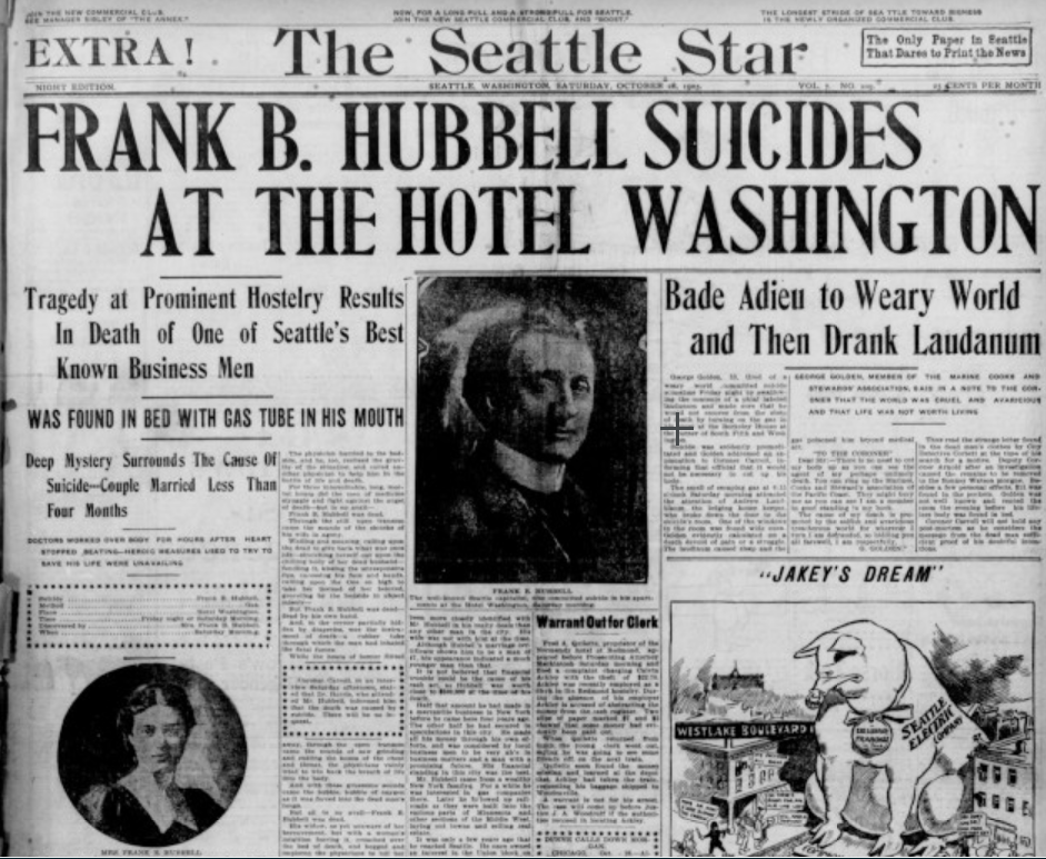
Apparently, Frank B. Hubbell died in 1905, only a few months after he married Helen. As the (Walla Walla) Evening Statesman reported on October 28 of that year, under the headline ‘Seattle capitalist commits suicide’,

Mystery surrounds the suicide by gas last night of Frank B. Hubbell, one of the most prominent real estate men and capitalists in the city. His bride of three months, who occupied separate apartments in a fashionable hotel, discovered him unconscious on the floor of his room this morning. Hubbell was worth half a million dollars and his financial standing was gilt edge. He came from New York a few years ago. Three physicians failed to save his life and he died at 10 this morning. No cause is known for his suiciding. Hubbel [sic] when found had the gas tube in his mouth. Domestic and not financial troubles, are believed to have been the cause. Hubbell had under way some of the greatest public improvements in the history of the city. He has constantly been drawing on eastern capital to accomplish his plans.

Though the Evening Statesman did not believe financial troubles to be the cause of his suicide, The Yakima Herald reported in 1910, under the headline ‘Closing of Hubbell estate solves suicide mystery’, that he owed $135,000 to Seattle banks, could not pay without putting his fortune at risk, and so decided to kill himself to keep his creditors at bay and preserve his estate for his wife. (That figure corresponds to $3.5 million in today’s money. The Herald went on to say that his total estate amounted to $650,000, or about $16.8 million.)

Front page of The Seattle Star, October 28, 1905

Frank and Helen Moore Hubbell had one daughter, Helen Frances Hubbell, who apparently died a few months after her 17th birthday in a car accident. She was born in May 1906, 6½ months after the death of her father. The elder Helen died in 1948 at the age of 70.