Fremont Avenue N begins at the north end of the Fremont Bridge (making it a continuation, in a sense, of both Dexter Avenue N and Westlake Avenue N) and goes 1⅙ miles north to N 50th Street and Woodland Park Zoo. It resumes north of the zoo at N 59th Street and goes 3½ miles to N 130th Street and Bitter Lake Playfield, a short portion of the block between N 61st Street and N 62nd Street being stairway. North of the lake, there are two short stretches: one going a couple blocks south from N 143rd Street, adjoining the Bitter Lake Reservoir, and another going a block south from the city limits at N 145th Street.
As with many North Seattle avenues, the Fremont name continues on into Shoreline. Its northernmost appearance is at the King–Snohomish county line at N 205th Street.
Born and raised in Seattle, Benjamin Donguk Lukoff had his interest in local history kindled at the age of six, when his father bought him settler granddaughter Sophie Frye Bass’s Pig-Tail Days in Old Seattle at the gift shop of the Museum of History and Industry. He studied English, Russian, and linguistics at the University of Washington, and went on to earn his master’s in English linguistics from University College London. His book of rephotography, Seattle Then and Now, was published in 2010. An updated version came out in 2015.
It has proved difficult to find a good photo of Phinney — this, the only one I could find online, is a group shot taken from a distance, so it’s hard to make him out — but I was able to find the below advertisement. His offer to refund the purchase price of “any lot, block, or acre” sold by him since 1881, with interest, is an impressive one — I wonder if anyone took him up on it? Ladd’s Addition later became part of Carleton Park; with the help of David Rumsey’s Georeferencer, I was able to determine that Governor Ferry’s blocks were located east of what is now W Viewmont Way W, between Parkmont Place W and W Raye Street.
An advertisement by Phinney in the Seattle Post-Intelligencer, March 4, 1888
Phinney Avenue N begins at N 34th Street in Fremont and goes just over 2 miles north to N 70th Street on Phinney Ridge. Resuming at N 85th Street in Greenwood, it goes ¾ of a mile north to N 100th Street. There is another 1¼-mile stretch from N 105th Street to N 130th Street in Bitter Lake, and then a final two blocks between N 141st Street and the city limits at N 145th Street. As with many North Seattle avenues, the Phinney name continues on into Shoreline; its northernmost appearance is just south of N 200th Street.
Born and raised in Seattle, Benjamin Donguk Lukoff had his interest in local history kindled at the age of six, when his father bought him settler granddaughter Sophie Frye Bass’s Pig-Tail Days in Old Seattle at the gift shop of the Museum of History and Industry. He studied English, Russian, and linguistics at the University of Washington, and went on to earn his master’s in English linguistics from University College London. His book of rephotography, Seattle Then and Now, was published in 2010. An updated version came out in 2015.
At any rate, Ordinance 6947, filed on June 6, 1901, refers to the street as Aurora Street, and Ordinance 7942, filed on November 5 of that year, refers to it as Aurora Avenue. I can find no specific record of the name change, but Ordinance 6864, filed on May 8, has to do with “altering, defining and establishing the names of streets in the City of Seattle in the portion thereof lying north of Lake Union, Salmon Bay and the route of the Lake Washington Canal,” and is likely responsible. (No text is available online for the ordinance, and the drafters of Ordinance 6947 must have neglected to take the change into account.)
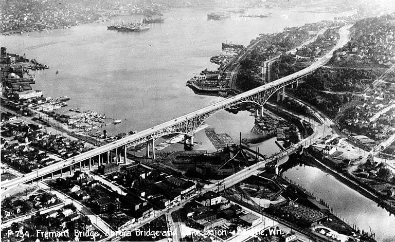
Aurora Avenue N might have remained just another North Seattle street were it not for the decision to route the Pacific Highway, U.S. Route 99, across the Lake Washington Ship Canal there instead of Stone Way N, Albion Place N, Whitman Avenue N, or Linden Avenue N. As it happened, Aurora was chosen as the location for the crossing (known today as the Aurora Bridge), and the name was officially extended through Queen Anne to Downtown Seattle in 1930 in preparation for the bridge’s opening in 1932.
Added July 14, 2023: I spoke to Feliks Banel of KIRO Newsradio for one of his All Over the Map segments, this one on how the Aurora Bridge got its name. I didn’t appear on air, but was mentioned in both the audio and web versions of the story.
Postcard of Lake Union, Lake Washington Ship Canal, the Fremont Bridge, and the George Washington Memorial Bridge (Aurora Bridge), circa 1932. View looks southeast, with Fremont in foreground. Public domain image from University of Washington Libraries Digital Collections.Aurora Bridge, 2011. View looks east, with Gas Works Park and Wallingford neighborhood at center, Lake Union and Capitol Hill at right. Public domain photo by Flickr user Mike Linksvayer.
Today, Aurora Avenue N begins at 7th Avenue N and Harrison Street by the north portal of the State Route 99 Tunnel and goes 7⅘ miles north to the city limits; the name continues 3 further miles to the King–Snohomish county line, and the highway another 12 miles beyond that to Broadway in Everett. A block-long segment from 6th Avenue and Battery Street to Denny Way has been renamed Borealis Avenue, and Aurora between Denny Way and Harrison Street is once again 7th Avenue N. A two-block-long segment underneath the north approach to the Aurora Bridge has also been changed to Troll Avenue N.
Born and raised in Seattle, Benjamin Donguk Lukoff had his interest in local history kindled at the age of six, when his father bought him settler granddaughter Sophie Frye Bass’s Pig-Tail Days in Old Seattle at the gift shop of the Museum of History and Industry. He studied English, Russian, and linguistics at the University of Washington, and went on to earn his master’s in English linguistics from University College London. His book of rephotography, Seattle Then and Now, was published in 2010. An updated version came out in 2015.
Holman Road NW runs 1³⁄₁₀ miles from 15th Avenue NW just north of NW 87th Street to the intersection of Greenwood Avenue N and N 105th Street. For its last couple of blocks, it is Holman Road N. Work began on the diagonal street, then known as Holman Road № 1, in 1926 and was completed in 1929. (Holman Road № 2 is today known as Westminster Way N in Shoreline.)
The road’s namesake was Axel Holman (1867–1962), who according to various obituaries was born in Sweden and arrived in Seattle in 1886. A real estate agent and builder in later life, he, according to the July 4, 1962, issue of the Ballard News-Tribune, “built the Sunset Highway [and] helped to build the Milwaukee railroad through the Cascades” as a construction engineer. The March 10, 1947, issue of The Seattle Times reports that “against considerable opposition, Holman was instrumental in obtaining construction of Holman Road No. 1 and No. 2, near the northwest edge of Seattle, and he still has the loving cup presented to him in 1929 by the Ballard Commercial Club in recognition of that service,” and the July 2, 1962, issue of the same paper adds that he “owned a mine in Dawson City during the Gold Rush and in 1897 assisted in plotting the town-site of Skagway. He also laid the first wagon roadbed from Skagway through White Pass to the goldfields.”
Axel Holman, from March 10, 1947, issue of The Seattle Times
Born and raised in Seattle, Benjamin Donguk Lukoff had his interest in local history kindled at the age of six, when his father bought him settler granddaughter Sophie Frye Bass’s Pig-Tail Days in Old Seattle at the gift shop of the Museum of History and Industry. He studied English, Russian, and linguistics at the University of Washington, and went on to earn his master’s in English linguistics from University College London. His book of rephotography, Seattle Then and Now, was published in 2010. An updated version came out in 2015.


.jpg)