Mountain View Drive S

This street, created in 1923 by Ordinance 45500, received its current name in 1929. Before then, it was part of 28th and 29th Avenues S. The mountain in question would be Mount Rainier, which, it was recently announced, is no longer 14,410 feet high, but rather 14,399.6, due to a melting icecap.

Mountain View Drive S begins at S Columbian Way and S Alaska Street and goes ⅙ of a mile southeast to 29th Avenue S and S Edmunds Street.

Montvale Place W

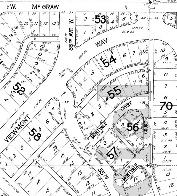
What is now Montvale Place W was originally Montvale Court W, created in 1915 as part of the plat of Carleton Park. When originally platted, Montvale Court formed a horseshoe-shaped loop, but at some point (the quarter section map doesn’t say, and I can find no relevant city ordinance), the eastern and southeastern part of the street, plus the alley connecting to 34th Avenue W, was renamed Montvale Place W.

Montvale Place W begins at 35th Avenue W south of Montvale Court W and goes ⅛ of a mile northeast, then north, to the intersection of Viewmont Way W, 34th Avenue W, and W Lynn Street.

Portion of plat of Carleton Park showing original course of Montvale Court W
Portion of plat of Carleton Park showing original course of Montvale Court W, over half of which is now Montvale Place W

Montvale Court W

Like Viewmont Way W, Crestmont Place W, Eastmont Way W, Westmont Way W, and Piedmont Place W, this street was created in 1915 as part of the plat of Carleton Park, their common mont element referring to the fact that, as The Seattle Times wrote, the “entire district commands an unobstructible view of the Cascade and Olympic Mountains.” Like Piedmont Place W, Montvale Court W lies at the foot of the western Magnolia hill as it slopes down to Pleasant Valley (of which vale is of course a variant).

Montvale Court W begins at 35th Avenue W south of Viewmont Way W and goes just over 300 feet northeast to Montvale Place W. (When it was originally platted, it formed a horseshoe-shaped loop back to 35th, but at some point the eastern and southeastern part of the street was renamed Montvale Place W.)

Portion of plat of Carleton Park showing original course of Montvale Court W

Ridgemont Way N

This street was created in 1925 as part of the plat of Ridgemont. Unnamed at the time, it was presumably later named after the subdivision. I say “presumably” because there is no record of its being named in Seattle’s online legislative database, which there should be if this was done after this part of town was annexed in 1953, and King County’s only goes back to 1969.

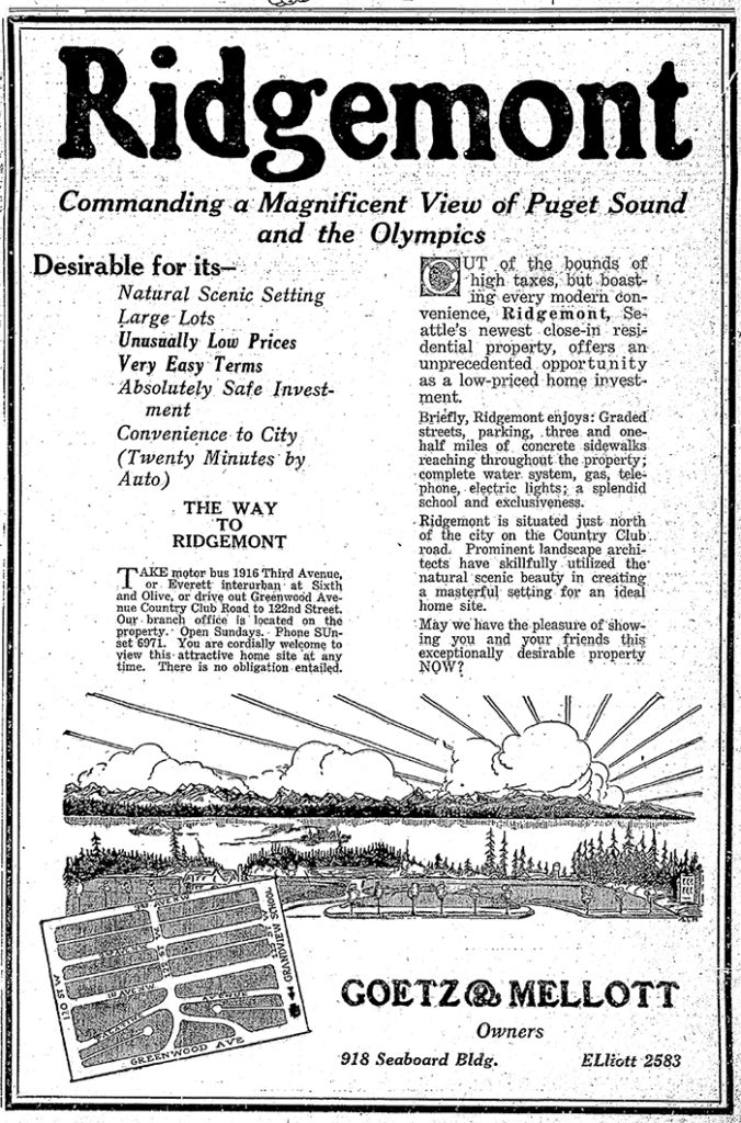
Ridgemont, as the below advertisement implies, was named for its location atop a ridge “commanding a magnificent view of Puget Sound and the Olympics.”

Ridgemont Way N begins at Greenwood Avenue N just south of N 125th Street and goes just over 425 feet southwest to N 122nd Street.

Advertisement for the Ridegmont subdivision, The Seattle Times, October 11, 1925
Advertisement for the Ridegmont subdivision, The Seattle Times, October 11, 1925. It would remain outside of the city and “out of the bounds of high taxes” for 28 years.

Alpine Way NW

This street, like NW Culbertson Drive, was created in 1955 as part of the plat of Llandover-by-the-Sound, and was presumably named for the property’s view of the Olympic Mountains to the west. (I say property, singular, because there is only one house with an Alpine Way address).

Alpine Way NW begins at NW Culbertson Drive and goes just over 325 feet south to NW Northwood Road.

Montavista Place W

Created in 1915 as part of the plat of Carleton Park, this is one of the many streets in the subdivision that features the mont element ― Piedmont Place W, Viewmont Way W, Crestmont Place W, Eastmont Way W, and Westmont Way W among them ― a reference to the “entire district[’s]… unobstructible view of the Cascade and Olympic Mountains” (The Seattle Times).

Montavista Place W begins at Magnolia Boulevard W and goes ⅖ of a mile northeast, then northwest, to 38th Avenue W.

Lake Dell Avenue

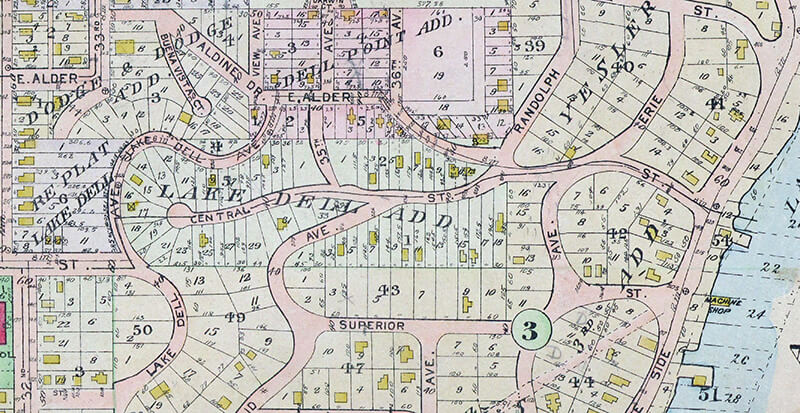
This street was created in 1890 as part of the Lake Dell Addition to the City of Seattle, the lake in question being Lake Washington, and the dell being the valley through which Lake Dell Avenue runs.

Lake Dell Avenue begins at 32nd Avenue just north of E Yesler Way and goes ⅓ of a mile to E Alder Street just west of 35th Avenue, forming part of the arterial connecting Yesler Way to Lakeside Avenue.

Portion of 1912 Baist real estate atlas of Seattle showing Lake Dell Addition
Landslide along Lake Dell Avenue, December 1933. Looking south from near the E Spruce Street right-of-way. Courtesy of the Seattle Municipal Archives, Identifier 8255
Lake Dell Avenue retaining wall, April 2012. Looking north from near the E Spruce Street right-of-way. Courtesy of the Seattle Municipal Archives, Identifier 174892

W Laurelhurst Drive NE

W Laurelhurst Drive NE and E Laurelhurst Drive NE were originally Olympic View Drive and Cascade View Drive, respectively, in the 1906 plat of Laurelhurst, an Addition to the City of Seattle. I am unable to tell exactly when the change was made: I first find “Laurelhurst Drive” being referred to in The Seattle Times in 1920, though a Kroll map from the same year shows the streets as 45th Avenue NE and 47th Avenue NE, respectively.

Laurelhurst itself was annexed to Seattle in 1910 (which makes me wonder why the plat was labelled as an addition to the city four years earlier). “Laurel” must refer to the tree, and “hurst” is an archaic word meaning “wooded hill.” However, as the English Language & Usage Stack Exchange thread that gives that definition notes, “in street names, [hurst is] likely to be a modern invention,” being part of “a name made up from old roots to imbue a sense of history and rootedness” (or, in cases like these, Britishness and stateliness). (I had thought that “Laurel” might refer to a girl or woman [cf. Loyal Avenue NW], but neither of the developers — Joseph Rogers McLaughlin [1851–1923] and Robert F. Booth [1875–1918] — appear to have had a relative by that name.)

(As an aside, the Wikipedia article on the Laurelhurst neighborhood in Portland, Oregon, citing Eugene E. Snyder’s 1979 Portland Names and Neighborhoods, says that “the name Laurelhurst was borrowed from a residential development in Seattle that Laurelhurst Company general manager Paul Murphy had recently completed. The name combined a reference to the laurel shrubbery near the Seattle development with the Old English hurst, denoting a wooded hill.” However, I have my doubts that there were actually enough laurels nearby to warrant the naming [in contrast to Magnolia, which was {mis}named for the plentiful madronas that lined the bluff].)

W Laurelhurst Drive NE begins at 43rd Avenue NE just south of NE 38th Street and goes ½ a mile southeast to just east of Webster Point Road NE, where it becomes E Laurelhurst Dr NE. From there, it goes nearly ⅖ of a mile northeast to a dead end just past 47th Avenue NE.

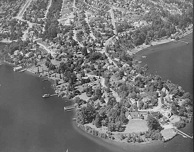
Aerial view of Laurelhurst from the south, 1938
Aerial view of Laurelhurst from the south, 1938. Webster Point dominates the view; W Laurelhurst Drive NE becomes E Laurelhurst Drive NE in front of the house that prominently appears at the southern end of the point. Photograph from the Seattle Post-Intelligencer Collection, Museum of History and Industry, licensed under Creative Commons Attribution 2.0 Generic
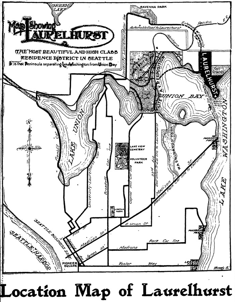
Map of Laurelhurst, Seattle Post-Intelligencer, October 21, 1906
Part of an advertisement for the new Laurelhurst subdivision, Seattle Post-Intelligencer, October 21, 1906. Laurelhurst is called “the most beautiful and high-class residence district in Seattle… that peninsula separating Lake Washington from Union Bay.” Prospective buyers were directed to take the Madison Street Cable Railway to its terminus at Madison Park, from which they could take a 5-minute ride on a steamer to Laurelhurst.

Mountain Drive W

This Magnolia street, created in 1915 as part of the plat of Carleton Park, was originally known as Mt. Olympus Drive. Because not all Seattle ordinances have been scanned, I am unable to tell when the change was made (and am unsure why it was made, as the old name doesn’t appear to conflict with anything).

The Seattle Times wrote of Carleton Park that the “entire district commands an unobstructible view of the Cascade and Olympic Mountains” ― being on the west side of the hill, the view here is of the Olympics, of which Mt. Olympus is the most prominent.

Mountain Drive W begins at Westmont Way W and Altavista Place W and goes ⅕ of a mile to Westmont Way W just east of W Viewmont Way W.

Piedmont Place W

Created in 1915 as part of the plat of Carleton Park, this street shares the mont element with a number of other streets in the subdivision, e.g., Viewmont Way W, Crestmont Place W, Eastmont Way W, and Westmont Way W. This because, as The Seattle Times wrote, the “entire district commands an unobstructible view of the Cascade and Olympic Mountains.” I tend to think the element was overused in the neighborhood and would have liked more of its streets to be named after the actual mountains, e.g., Ellinor Drive W and Constance Drive W. But I do have to hand it to whoever came up with these names for their creativity in naming Piedmont Place W — not, I am sure, directly after the region in Italy or that in the United States, but rather because it lies at the eastern foot — pied in French — of the western Magnolia hill as it slopes down to Pleasant Valley.

Piedmont Place W begins at W McGraw Street between 36th Avenue W and 35th Avenue W and goes ¼ mile north to W Raye Street.

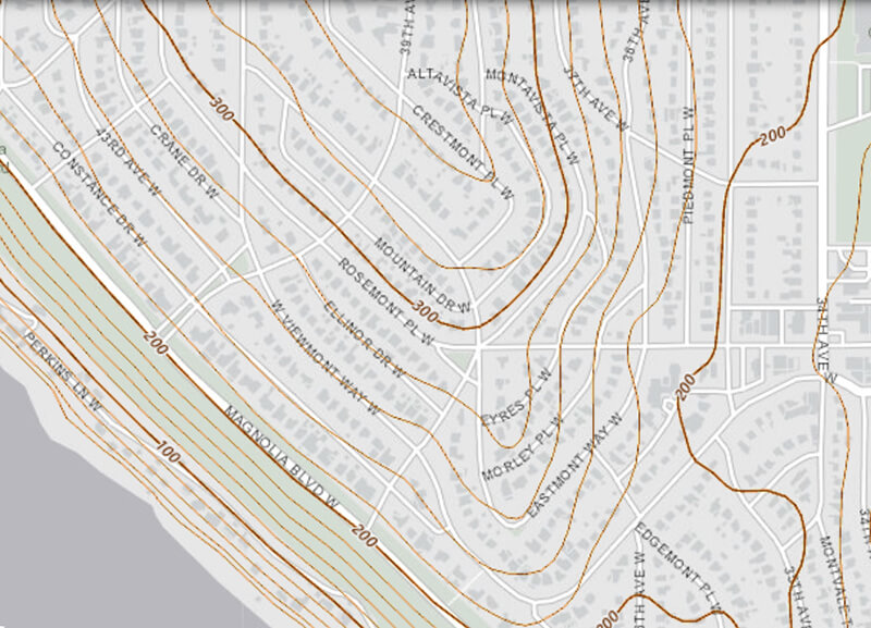
Topographic map of part of Carleton Park, from The National Map

Crestmont Place W

This street was created in 1915 as part of the plat of Carleton Park. The Seattle Times wrote of the Magnolia subdivision that the “entire district commands an unobstructible view of the Cascade and Olympic Mountains” — hence the mont portion of its name. Why crest? Because, as you can see on the topographical map below, Crestmont Place W is located at the crest of Carleton Park. (The highest point in all Magnolia, however, is located a number of blocks to the north, close to 40th Avenue W and W Barrett Lane.)

Crestmont Place W begins at Westmont Way W north of Altavista Place W and goes ¼ northeast, then northwest, to W Raye Street, where it becomes 40th Avenue W.

Topographic map of part of Carleton Park, from The National Map

Eastmont Way W

Like its twin, Westmont Way W, this street was created in 1915 as part of the plat of Carleton Park, which “afford[ed] a scenic frontage for every building lot in the addition,” according to The Seattle Times. Just as Westmont faces the Olympic Mountains to the west and southwest, Eastmont faces the Cascades to the southeast.

Beginning at Eastmont Place, a pocket park at the south end of Westmont Way W, it goes around 850 feet northeast to W McGraw Street, where it becomes 36th Avenue W.

Westmont Way W

In Viewmont Way W, I discuss the 1915 plat of Carleton Park, in which, as The Seattle Times reported,

The streets and boulevards curve and swing about the bases of elevated portions, escaping the deep cuts and heavy fills that would be necessary in conforming to the strict, rectangular plans of the old plat, and affording a scenic frontage for every building lot in the addition.

Many streets in the subdivision were named in reference to these views, Westmont Way W among them. Beginning at Eastmont Place, a pocket park at the south end of Eastmont Way W, it goes ⅖ of a mile north, then northwest, to W Viewmont Way W, providing westerly and southwesterly views of the Olympic Mountains for its entire length.

Mount Adams Place S

Like Mount Rainier Drive S, Mount St. Helens Place S, and S Mount Baker Boulevard, this street was created in 1907 as part of the Mt. Baker Park addition, named for its view of Mount Baker in the North Cascades. Like the others, it was named after a prominent Cascade Range peak — in this case, Mount Adams.

At 12,281 feet, Adams is the second tallest mountain in Washington, behind Mount Rainier. Known by Native Americans as Pahto or Klickitat, it was named for President John Adams (1735–1826), in a rather roundabout way. Unlike Rainier or St. Helens, it was neither “discovered” by George Vancouver nor named by him; instead, the first non-Natives to spot it were Lewis and Clark, who at first thought they had spotted St. Helens. Then, as Wikipedia relates,

For several decades after Lewis and Clark sighted the mountain, people continued to get Adams confused with St. Helens, due in part to their somewhat similar appearance and similar latitude. In the 1830s, Hall J. Kelley led a campaign to rename the Cascade Range as the President’s Range and rename each major Cascade mountain after a former president of the United States. Mount Adams was not known to Kelley and was thus not in his plan. Mount Hood, in fact, was designated by Kelley to be renamed after President John Adams and St. Helens was to be renamed after George Washington. In a mistake or deliberate change by mapmaker and proponent of the Kelley plan Thomas J. Farnham, the names for Hood and St. Helens were interchanged. And, likely because of the confusion about which mountain was St. Helens, he placed the Mount Adams name north of Mount Hood and about 40 miles (64 km) east of Mount St. Helens. By what would seem sheer coincidence, there was in fact a large mountain there to receive the name. Since the mountain had no official name at the time, Kelley’s name stuck even though the rest of his plan failed. However, it was not official until 1853, when the Pacific Railroad Surveys, under the direction of Washington Territory governor Isaac I. Stevens, determined its location, described the surrounding countryside, and placed the name on the map.

Mount Adams Place S begins at Mount St. Helens Place S and goes ¼ mile southeast to S Ferris Place.

Mount St. Helens Place S

Like Mount Rainier Drive S and S Mount Baker Boulevard, this street was created in 1907 as part of the Mt. Baker Park addition, named for its view of Mount Baker in the North Cascades. The neighborhood featured a number of other streets named for mountains in the Cascade Range, including this one, named after Mount St. Helens.

St. Helens, of course, is best known for its volcanic eruption on May 18, 1980, “the deadliest and most economically destructive volcanic event in U.S. history” according to Wikipedia. It was variously known by the Native Americans as Lawetlat’la (Cowlitz) and Loowit or Louwala-Clough (Klickitat), and, like Mount Rainier and Mount Baker, was given its official English-language name by George Vancouver on HMS Discovery in 1792. In this case, it honored his friend Alleyne FitzHerbert, 1st Baron St Helens (1753–1839), who at the time was British ambassador to Spain.

Mount St. Helens Place S begins at Cascadia Avenue S and goes just over ¼ mile south to Mount Rainier Drive S at 37th Avenue S.

Mount Rainier Drive S

This street was created in 1907 as part of the Mt. Baker Park addition, named for its view of Mount Baker in the North Cascades. In addition to S Mount Baker Boulevard, the neighborhood featured a number of other streets named for mountains in the Cascade Range, including this one, named after Mount Rainier.

According to Wikipedia, at 14,411 feet, Mount Rainier is “the highest mountain in… Washington and the Cascade Range, the most topographically prominent mountain in the contiguous United States, and the tallest in the Cascade Volcanic Arc.” It has been known by a number of other names, including Tacoma (after which, incidentally, Takoma Park, Maryland, was named), which derived from its Lushootseed-language name, təqʷubəʔ (‘permanently snow-covered mountain’). It was given its official English-language name by George Vancouver on HMS Discovery in 1792:

The weather was serene and pleasant, and the country continued to exhibit between us and the eastern snowy range the same luxuriant appearance. At is northern extremity, Mount Baker bore by compass N. 22 E.; the round snowy mountain, now forming its southern extremity, and which, after my friend, Rear Admiral [Peter] Rainier [17411808], I distinguish by the name of Mount Rainier, bore N. 42 E.

Mount Rainier Drive S begins at the intersection of S McClellan Street, Lake Park Drive S, and Mount Baker Drive S, and goes ¼ mile southeast to S Hanford Street and Hunter Boulevard S.

S Fidalgo Street

This street was created in 1889 as part of the Commercial Street Steam Motor Addition to the City of Seattle. It appears to have been named for Fidalgo Island in Skagit County, which is about 60 miles to the northwest, as S Orcas Street appears to honor Orcas Island and Padilla Place S, Padilla Bay. The island itself was named after Salvador Fidalgo y Lopegarcía, who explored the area for the Spanish in the early 1790s.

S Fidalgo Street begins at a shoreline street end on the Duwamish Waterway just west of Ohio Avenue S and goes 700 feet east to E Marginal Way S. It picks up again at 1st Avenue S and goes half a mile east, then southeast, to a dead end just east of Padilla Place S.

S Orcas Street

This street was created in 1889 as part of the Commercial Street Steam Motor Addition to the City of Seattle. It appears to have been named for Orcas Island, largest of the San Juan Islands, which is about 75 miles to the northwest, as S Fidalgo Street appears to honor Fidalgo Island and Padilla Place S, Padilla Bay. The island’s name, per Wikipedia, derives from that of “Juan Vicente de Güemes Padilla Horcasitas y Aguayo, 2nd Count of Revillagigedo, the Viceroy of New Spain who sent an exploration expedition under Francisco de Eliza to the Pacific Northwest in 1791.” Eliza named the surrounding area Horcasitas, but in 1847 the British, who maintained their claim on the San Juans until 1871, assigned a shortened version — Orcas — specifically to the island. (It is a coincidence that Orcas Island is an excellent location for watching orca whales; the two names are completely unrelated.)

S Orcas Street begins at E Marginal Way S and goes ¾ of a mile east, then southeast, to Corson Avenue S, where it becomes S Doris Street. It picks up again east of Interstate 5 at 15th Avenue S and goes three blocks east to 18th Avenue S. Its longest and final stretch begins just west of 20th Avenue S and goes 2¼ miles east to Lake Washington Boulevard S just west of Seward Park.

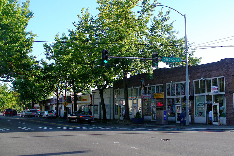
Intersection of S Orcas Street and Rainier Avenue S
Intersection of S Orcas Street and Rainier Avenue S, Columbia City, September 2008. Photograph by Flickr user Matthew Rutledge, licensed under Creative Commons Attribution-NonCommercial 2.0 Generic

Seola Beach Drive SW

According to Seattle parks historian Don Sherwood’s sheet on Seola Park, this street began as a logging railroad. It was then replaced by the Charles Arey county road (“recently surveyed,” according to an article in the August 26, 1893, Seattle Post-Intelligencer), which was renamed Qualheim Road in 1914 by Carl Olsen Qualheim. It received its current name in 1956 when that portion of Arbor Heights was annexed to Seattle. “Seola” itself was the product of a naming contest:

In 1893, a family named Kakeldy built the first home on the beach.… Before long, children in the vicinity school referred to residents of Kakeldy Beach as the “Cackilty Chickens.”… In 1910 the beach residents sponsored a renaming contest which was won by Mel Miller, friend of the school’s teacher of Spanish, Agnes Quigley; his suggestion: “Se-ola = to know the wave.”

Seola Beach Drive SW begins at SW 106th Street between 28th Avenue SW and 31st Avenue SW and goes ⅞ of a mile south, then southwest, to a dead end at the beach, just past SW Seola Lane.

For its entire length, Seola Beach Drive SW forms the southern city limits of Seattle, separating it from Burien and unincorporated King County (White Center). (Unlike the northern city limits, formed by 145th Street, Seattle’s southern city limits are jagged. If they went due east from Seola Beach, Seattle would encompass large portions of Burien, Tukwila, and Renton; whereas if they followed a parallel set at the city limits’ northernmost point, everything south of Kenyon Street [approximately the north end of the South Park Bridge] would be lost to Seattle.)

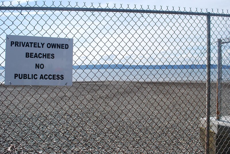
Sign reading Privately Owned Beaches, No Public Access at Seola Beach
Seola Beach, April 8, 2011. Unfortunately, this is not a case where a street was platted into the water, creating a shoreline street end; the right-of-way explicitly ends at the fence, and this portion of the beach belongs to the property owners to the south. Photograph by Flickr user NabeWise, licensed under Creative Commons Attribution 2.0 Generic

Lake Shore Drive S

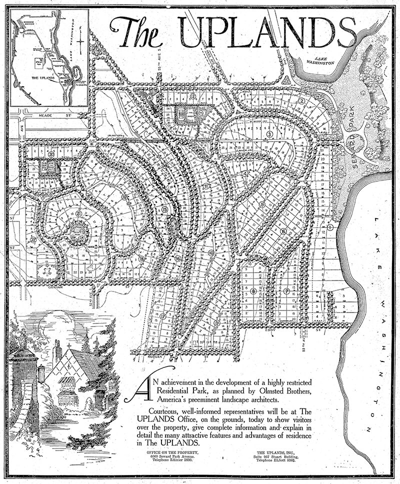
This street, created in 1926 as part of the plat of The Uplands (S Upland Road), was so named because it runs along the Lake Washington shoreline just south of Seward Park.

Full-page ad for The Uplands in The Seattle Times, September 27, 1925
Full-page ad for The Uplands in The Seattle Times, September 27, 1925. Lake Shore Drive is at the lower right-hand corner of the plat.

Lake Shore Drive S begins at Seward Park Avenue S and S Hawthorn Road and goes ¼ mile south to S Eddy Street.