Yesler Way

This street is named after Henry Leiter Yesler (1810–1892). Originally from Leitersburg, Maryland, which was founded by his great-grandfather, and living in Massillon, Ohio, before coming west, he moved to Seattle from Portland, Oregon, in 1852. As John Caldbick writes for HistoryLink.org:

…[Yesler] quickly established himself as the most important resident of the rain-swept little spot that would soon become Seattle. He had the first steam-powered sawmill on Puget Sound up and running within months, and for several years he employed almost every male settler in Seattle and a considerable number of Native Americans. His mill was early Seattle’s only industry, and without it the town’s development would have been greatly delayed.

Carson Dobbins Boren and David Swinson “Doc” Maynard had already claimed land on Elliott Bay either side of what is today Pioneer Square, but they gave him part of their claims so he could access the water from the claim he made farther up First Hill. Yesler’s mill was built at the foot of what is now Yesler Way but was originally Mill Street, also known as Skid Road — and yes, Seattle may be where the term originated, referring to a neighborhood largely inhabited by the “down and out.”

Yesler was also King County auditor in 1852, and Seattle mayor from 1874 to 1875 and 1885 to 1886.

Yesler had two children: a son, Henry George Yesler (1845–1859), by his wife, Sarah Burgert Yesler (1822–1887); and a daughter, Julia Benson Intermela (1855–1907). Her mother wasn’t Sarah, who didn’t come to Seattle until 1858, but rather a Duwamish woman named Susan, daughter of Salmon Bay Curley (Su-quardle), who had worked at Yesler’s mill. When Sarah finally joined her husband, he sent Susan and Julia to live with Jeremiah S. Benson, a cook at the mill. In the 1870 territorial census, Julia is listed as living with the Bensons, but the next year she is listed as a HB (“half-breed”) house servant for the Yeslers. Unlike Rebecca Lena Graham, who successfully sued the relatives of Franklin Matthias to be recognized as his rightful heir, Julia inherited nothing when her father died in 1892. Even so,

…The settlement of Henry Yesler’s estate was an imbroglio of epic proportions. It pitted Minnie Gagle Yesler [a younger cousin whom he married a few years before his death] and her mother against James Lowman [his nephew] and municipal authorities, who believed that Yesler had made a will that left most of his fortune, by then worth more than $1,000,000, to the city, hoping thereby to cement his reputation as the “Father of Seattle.”

Yesler is also quoted as anticipating “Strange Fruit” by 55 years… though it’s by no means a sentiment Abel Meeropol or Billie Holiday would have shared. In January 1882, a mob lynched James Sullivan, William Howard, and Benjamin Paynes between two of his maple trees. Harper’s Weekly reported Yesler’s reaction: “That was the first fruit them trees ever bore, but it was the finest.”
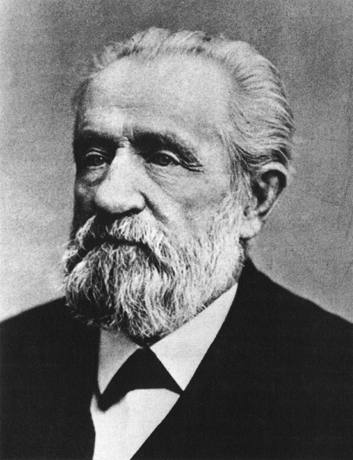
Henry L. Yesler
Henry L. Yesler. Courtesy of the Seattle Municipal Archives, Identifier 12257

Yesler Way begins on the Elliott Bay waterfront at Alaskan Way and goes 2⅙ miles east to Leschi Park, just past 32nd Avenue. It also appears just west of Lake Washington Boulevard, where it goes about 200 feet west and essentially serves as a driveway for a couple of houses.

Yesler Way, which becomes E Yesler Way east of Broadway, also divides three of the city’s directional designation zones from each other. South of Yesler, east–west streets carry the S prefix and north–south avenues carry the suffix S. North of Yesler, north–south avenues carry no suffix; east–west streets carry the E prefix east of Broadway and no prefix west of Broadway.
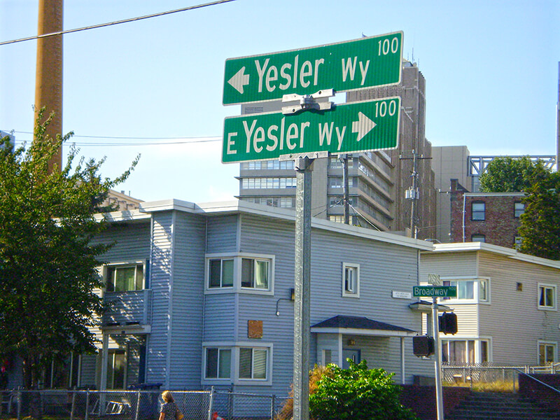
Street sign at corner of Yesler Way and Broadway, August 25, 2009
Street signs at corner of Yesler Way and Broadway, August 25, 2009. Photograph by Benjamin Lukoff. Copyright © 2009 Benjamin Lukoff. All rights reserved.

Terrace Street

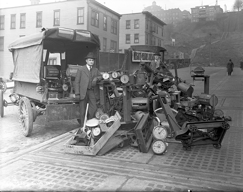
This street — named Pine Street in Terry’s Second Addition to the Town of Seattle, filed in 1872 — was renamed Terrace in 1876, presumably to avoid duplicating the Pine Street to the north. My assumption is it was given this name because of how steep First Hill is at this point — Paul Dorpat, writing for HistoryLink, says “Except at Terrace Street on the south and near Union Street on the north, the hill was readily negotiable first by hikers and later by street graders and trolley tracks.” One can see in the image below the long, steep stairway in the Terrace Street right-of-way “from 5th Avenue east to beyond 7th Avenue,” as Dorpat writes on his own blog.

Official from Seattle Weights and Measures Division with confiscated scales standing in Terrace Street
Seattle Weights and Measures Division officials standing with confiscated scales in Terrace Street, 1917. Note long stairway in upper-right corner. Courtesy of the Seattle Municipal Archives, Identifier 1210.

Today, Terrace Street begins at Yesler Way above 4th Avenue and goes a block and a half up the hill before being blocked by Interstate 5. It resumes just east of Harborview Medical Center and goes ⅓ of a mile east to 12th Avenue. There is another short stretch of E Terrace Street from 20th Avenue to 23rd Avenue by Garfield High School, and then a final ½ mile from 30th Avenue to Lake Washington Boulevard in Leschi, the portion between 36th Avenue and Randolph Avenue being a stairway.

E Remington Court

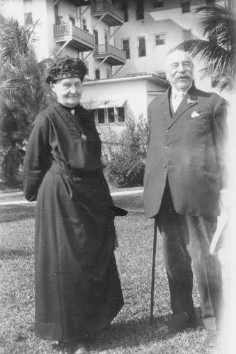
This street, which goes 600 feet from 12th Avenue in the west to 14th Avenue in the east, a block south of E Jefferson Street, was named as part of Greene’s Replat of Block 10, Squire Park Addition to the City of Seattle in 1903 by William Kimball Greene (1869–1940), transferring the Remington name a block south from Jefferson, the street it was originally applied to in 1890 by Watson Carvosso Squire (1838–1926), who had been territorial governor of Washington from 1884 to 1887 and Washington’s senator from statehood in 1889 to 1897.

Squire married Ida Remington in 1868; the next year, William Kimball Greene was born to Ida’s younger sister, Catherine, and her husband, Elijah Priest Greene. Ida and Catherine’s father, Philo, was the son of Eliphalet, who in 1816 had founded what became E. Remington and Sons, predecessor of Remington Arms and, via Remington Typewriter Company, Remington Rand and its successor, IT company Unisys.

Because Squire was the first to apply the name to a street, I count E Remington Court as ultimately being named after his wife, Ida, though one could say Greene’s preservation of the name, after the E Jefferson Street name had been extended by ordinance in 1895 from First Hill to Lake Washington, might also have been to honor his mother, Catherine.

Watson C. Squire and his wife, Ida Remington, circa 1910.
Watson Carvosso Squire and his wife, Ida Remington, circa 1910

E Spruce Street

This street, like Alder Street and Fir Street — all, of course, named for trees — originates in the 1872 plat of Terry’s Second Addition to the Town of Seattle, filed by Arthur Armstrong Denny, Henry Leiter Yesler, Erasmus Smithers, and Franklin Matthias, the last two as executors of the estate of Charles Carroll Terry, who was part of the Denny Party of settlers in 1851, and died in 1867. However, it was originally named Cedar Street (duplicative of another in Belltown). It received its current name as part of the Great Renaming of 1895, when Cedar Street, Prince William Street, and Erie Street were all changed to Spruce.

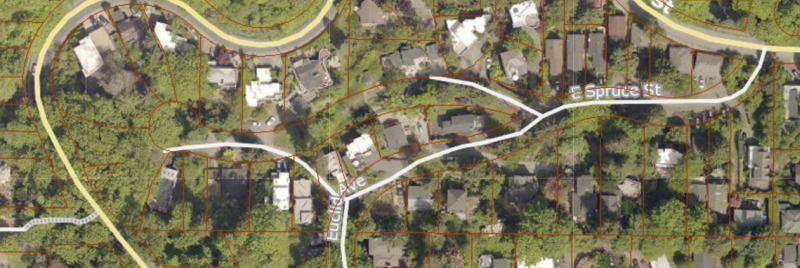
Today, E Spruce Street begins at Broadway and goes nearly a mile east to 25th Avenue, only interrupted once, at Boren Avenue, which it connects to as a pair of stairways. It resumes at 28th Avenue and goes just over ¼ of a mile to Lake Dell Avenue (the portion from Peppi’s Playground through Peppi’s Woods as a stairway). Farther east, there is a couple-hundred-foot-long section at the west end of Euclid Avenue, and then a longer one — almost ⅒ of a mile — from near the east end of Euclid Avenue to E Alder Street. (Its complicated end is the result of platted streets not always matching up with topography, or with where people actually ended up building roads.)

Portion of King County Parcel Viewer showing E Spruce Street right-of-way from Lake Dell Avenue to E Alder Street along with Euclid Avenue
King County Parcel Viewer showing E Spruce Street right-of-way from Lake Dell Avenue in the west to E Alder Street in the east. Instead of the eastern portion of Spruce connecting directly to the western portion, there is a gap; instead, the western portion connects to Euclid Avenue by going through private property.

Fir Street

This street, like nearby Alder Street — both, obviously, named for trees — originates in the 1872 plat of Terry’s Second Addition to the Town of Seattle, filed by Arthur Armstrong Denny, Henry Leiter Yesler, Erasmus Smithers, and Franklin Matthias, the last two as executors of the estate of Charles Carroll Terry, who was part of the Denny Party of settlers in 1851, and died in 1867.

Today, Fir Street begins where 8th Avenue and 9th Avenue meet, a block south of Harborview Medical Center. From there to its end at Martin Luther King Jr. Way 1⅕ miles to the east, it is almost completely uninterrupted, except for the portion west of 11th Avenue being blocked by a retaining wall at Boren Avenue.

Alder Street

This street originates in the 1872 plat of Terry’s Second Addition to the Town of Seattle, filed by Arthur Armstrong Denny, Henry Leiter Yesler, Erasmus Smithers, and Franklin Matthias, the last two as executors of the estate of Charles Carroll Terry, who was part of the Denny Party of settlers in 1851, and died in 1867. (In 1857, Matthias was listed as being a carpenter, originally from Indiana, Pennsylvania; not too long thereafter, he apparently married and had a child with the daughter of Shilshole Curley [native name Saxkla’xid{?}], “head-man” of the shill-shohl-AHBSH village at šilšul on Salmon Bay. This child, Rebecca Lena Graham, later had to sue Matthias’s relatives to be recognized as his rightful heir. You can read more about her on the Yale University Press blog, at Fitz-Henry Family History, and in the Pacific Northwest Quarterly.)

Today, Alder Street begins at the south entrance to the Harborview Medical Center parking garage, its original first few blocks having been obliterated by Interstate 5, and goes ⅓ of a mile northeast and then east to the Children and Family Justice Center at 12th Avenue.* It resumes at 14th Avenue and goes just over a mile to 32nd Avenue. Finally, just west of 35th Avenue, the Lake Dell Avenue arterial becomes E Alder Street, which snakes ⅕ of a mile down the hill to end at Lake Washington Boulevard. It was originally part of a group of streets named after trees — Pine, Alder, Cedar, and Fir — though Pine and Cedar have since become Terrace and Spruce, since they duplicated street names in other parts of Downtown.

* The Alder Street right-of-way technically begins at Yesler Way just west of 6th Avenue, but is unimproved and indistinguishable from the adjacent open space, and the Interstate 5 right-of-way begins on the east side of 6th.

Pike Street

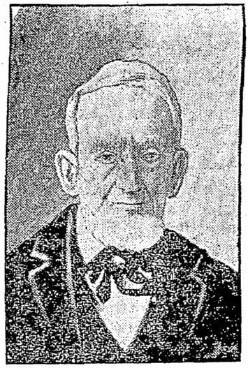
Pike Street first appears in the Plat of an Addition to the Town of Seattle as Laid Out by Arthur A. Denny, filed on April 5, 1869. It was named by Denny for John Henry Pike (1814–1903), best known for being the architect and builder of the original Territorial University of Washington in 1861. This article by Rob Ketcherside is the most comprehensive information available online about Pike. “Early Pikes in Seattle,” by Stuart Pike, is also worth a read. (Also of note: Pike’s son, Harvey Lake Pike [1842–1897], was the first person to try to connect Lake Washington’s Union Bay to Lake Union’s Portage Bay by a canal. This was unsuccessful, but he did end up platting the land in 1869 as Union City. His E North Street [north of the proposed canal] survives to this day.)

John Pike, from his obituary in the November 22, 1903, issue of The Seattle Times

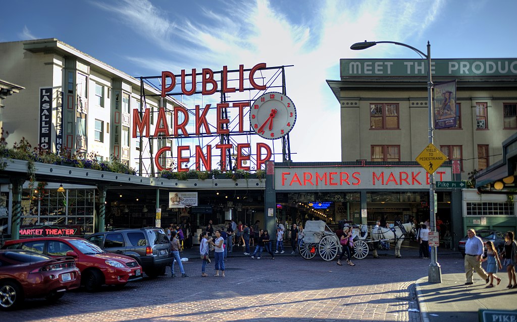
In the original plat, Pike Street (as well as Union and Pine Streets) begins at Front Street — today’s 1st Avenue — but today it begins on the Elliott Bay waterfront at Alaskan Way as the Pike Street Hillclimb. Pike Street proper begins at Pike Place (home of the eponymous market) and Post Alley (underneath the Market Theater sign), both shown below, and makes it a full 1⅔ miles to just past 18th Avenue in the Central District before being interrupted. It then resurfaces at 23rd Avenue and goes another ⅘ of a mile to Grand Avenue in Madrona, a few blocks east of Lake Washington.

Pike Place Market entrance, corner of Pike Street and Pike Place, 2012
Pike Place Market entrance, corner of Pike Street and Pike Place, 2012. Photograph by kissmykumbaya, Wikimedia Commons (public domain)

Madison Street

Madison Street — another of Seattle’s “first streets” — was named for James Madison, president of the United States from 1809 to 1817. It is the only street in town that stretches, uninterrupted, from the salt water of Elliott Bay and Puget Sound to the fresh water of Lake Washington.

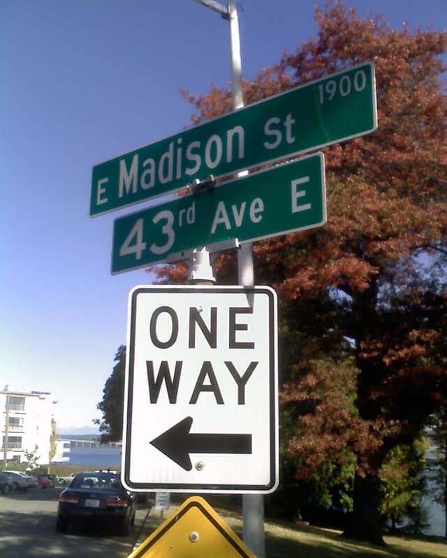
Originating as the McGilvra Road in 1861, Madison Street begins on the Elliott Bay waterfront at Alaskan Way and ends 3¾ miles northeast of there at a small fishing pier, just east of 43rd Avenue E and north of Madison Park Beach. Apart from a slight bend to the northeast at 22nd Avenue, it is as straight as an arrow from beginning to end.

Signs at corner of E Madison Street and 43rd Avenue E, October 11, 2009
Signs at corner of E Madison Street and 43rd Avenue E, October 11, 2009. Photograph by Benjamin Lukoff. Copyright © 2009 Benjamin Lukoff. All rights reserved.

Spring Street

Spring Street was another of Seattle’s “first streets.” Sophie Frye Bass writes in Pig-Tail Days in Old Seattle:

Where springs of clear water bubbled from the earth and the beach was sandy and free from rocks, there the Indians camped. Such a choice spot was Tzee-tzee-lal-litch [dzidzəlalič], which Arthur Denny called Spring Street.

Spring Street begins at Alaskan Way and runs nearly a mile, to Harvard Avenue, before it is interrupted. A few more segments run through the Central District and Madrona. The last is from 38th Avenue to Grand Avenue, at which point it continues to Lake Washington Boulevard as a footpath and stairway.

Cherry Street

Cherry Street was among the first streets platted in Seattle on May 23, 1853. Sophie Frye Bass, author of Pig-Tail Days in Old Seattle, writes:

I choose to think that Cherry Street is named for the little town of Cherry Grove, Illinois — Mother’s birthplace — where the Dennys started on their long journey over the Oregon Trail.

“Mother,” in this case, refers to Louisa Catherine Denny Frye, one of three children of Arthur Armstrong Denny and Mary Ann Boren Denny of the Denny Party. She was 7 years old when they landed at Alki Point in November 1851.

In 2006, Hunter Brown wrote a People’s History essay for HistoryLink, “Finding Cherry Grove,” detailing his efforts to locate Cherry Grove, whose name was later changed to Cedar Township. The nearest town today is called Abingdon.

Bass began her Pig-Tail Days piece on Cherry Street by calling it “another up-and-up street… with no interferences. It begins at First Avenue, goes east and ends at Thirty-seventh avenue.” This is no longer quite the case because of a very small gap at the south end of the Seattle University campus. Today, Cherry begins at 1st Avenue and ends a block east of Broadway. It starts up again a couple hundred feet to the east as a continuation of the James Street/E James Way arterial, and then does go on to 37th Avenue in Madrona. All told it is 2⅓ miles long.

Marion Street

Marion Street, like James Street, was one of the first streets platted in Seattle on May 23, 1853. It, too, was named by Arthur Armstrong Denny after his younger brother, James Marion Denny (1824–1854). 

Marion Street runs ⅖ of a mile from Alaskan Way to 6th Avenue, where it is interrupted by Interstate 5. It picks up again at 7th Avenue and runs about the same distance to Broadway, where the Seattle University campus begins. East of there it runs in sections of varying lengths until it ends for good at 38th Avenue and Madrona Park.

James Street

James Street, one of the first streets platted in Seattle on May 23, 1853, was named by Arthur Armstrong Denny after his younger brother, James Marion Denny (1824–1854). Histories of Seattle report that James was too sick to leave Oregon and come to Puget Sound with the Denny Party and, indeed, he died in the town of Sublimity, Oregon, just a year after the street was named for him. Nothing I have found reports an actual cause of death. Marion Street is also named after this brother.

James Street runs ¾ of a mile from Yesler Way just east of 1st Avenue to an alley just east of Broadway. It appears east of there in a few short stretches and finally as a stairway from 38th Avenue to Lake Washington Boulevard at Madrona Park.