This road is named after Seward Park, which occupies all of Bailey Peninsula’s 300 acres, as envisioned by the Olmsted Brothers. The park itself was bought by the city in 1911 and named after William Henry Seward (1801–1872), who was governor of New York from 1839–1842, senator from New York from 1849–1861, and secretary of state under Abraham Lincoln and Andrew Johnson from 1861–1869. His negotiation of the purchase of Alaska from Russia in 1867 proved to be a major boon for Seattle, which nearly doubled its population between 1890 and 1900 due in no small part to the Klondike Gold Rush, and remains a gateway to Alaska to this day.
Seward Park Road begins at Lake Washington Boulevard S and S Juneau Street and winds for ⅓ of a mile into the park’s interior, where it becomes a ¾-mile-long loop. (It should not be confused with Shore Loop Road, which runs along the park’s perimeter on the Lake Washington shoreline and is not open to vehicle traffic. Like all park roads in Seattle, Seward Park Road carries no directional designation)
Article in The Seattle Times on the naming of Seward Park, June 11, 1911. William Elder Bailey paid $26,000 to buy Bailey Peninsula in 1889 and the city began to consider it a potential park shortly thereafter. (It had previously been known as Graham Peninsula, after early settler David Graham, and Andrews Peninsula [though no one is sure who this Andrews might have been].) Bailey made it difficult for the city, finally offering to sell it for $430,000 in 1908, but the city ended up acquiring it for a more reasonable $322,000 in early 1911. Read more at HistoryLink.org and Friends of Seward Park.
Aerial view of Seward Park from the south, circa 1965–1966. The Martha Washington School for Girls, (closed 1971, now Martha Washington Park) is in the foreground. Mercer Island and Lake Washington are in the background. Courtesy of the Seattle Municipal Archives, Identifier 192974.
Born and raised in Seattle, Benjamin Donguk Lukoff had his interest in local history kindled at the age of six, when his father bought him settler granddaughter Sophie Frye Bass’s Pig-Tail Days in Old Seattle at the gift shop of the Museum of History and Industry. He studied English, Russian, and linguistics at the University of Washington, and went on to earn his master’s in English linguistics from University College London. His book of rephotography, Seattle Then and Now, was published in 2010. An updated version came out in 2015.
This street, created in 1890 as part of the plat of the Denny-Fuhrman Addition to the City of Seattle, was originally named Randall Street. I haven’t been able to pinpoint the reason for or date of the name change, but it first appears in The Seattle Times and in the city’s ordinances in 1906. The street and addition were named for Henry Fuhrman (1843–1907), who developed the area with David Thomas Denny (1832–1903) (Denny Way).
Fuhrman, who had come to Seattle in 1890, was a German Jew. According to his Seattle Times obituary, he “came to this country from Germany when a boy.… He was engaged as a mercantile solicitor in the early days, but later started a small drygoods business in Fremont, Nebraska, where he has since become famous as the pioneer wholesale drygoods merchant west of Omaha.… It is estimated that his fortune amounts to at least a million dollars.”
Fuhrman and Charles Cowen (né Cohen) (1869–1926) (Cowen Place NE) are the only Jews I am aware of who have Seattle streets named after them. (Note added November 9, 2024: Now there’s a third: Sue Bird [born 1980] [Sue Bird Court N]).
Henry Fuhrman, from his Seattle Times obituary, August 23, 1907
Fuhrman Avenue E begins at the north end of Fairview Avenue E, under the Ship Canal Bridge, and goes nearly ½ a mile southeast to E Shelby Street, where it becomes Boyer Avenue E. (A short segment begins about 150 feet to the east of Boyer, heads about 225 feet to the south, and mainly functions as a driveway for a number of houseboats; and another short segment begins at the north end of 15th Avenue E at the E Calhoun Street pathway, heads about 275 feet to the northeast, and serves as a driveway for an apartment complex.)
Born and raised in Seattle, Benjamin Donguk Lukoff had his interest in local history kindled at the age of six, when his father bought him settler granddaughter Sophie Frye Bass’s Pig-Tail Days in Old Seattle at the gift shop of the Museum of History and Industry. He studied English, Russian, and linguistics at the University of Washington, and went on to earn his master’s in English linguistics from University College London. His book of rephotography, Seattle Then and Now, was published in 2010. An updated version came out in 2015.
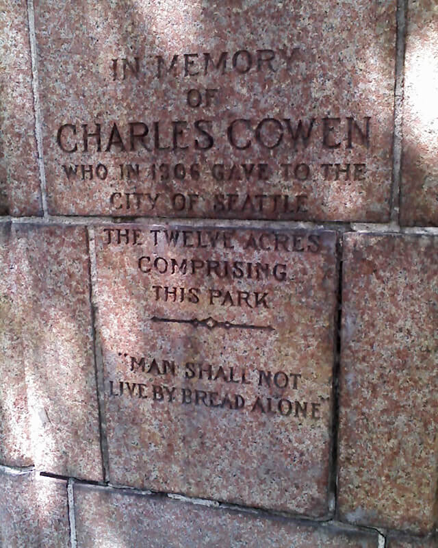
This street was created as part of the 1906 plat of Cowen’s University Park, filed by the Sylvester-Cowen Investment Company, of which Charles Cowen (1869–1926) was president. Originally Ravenna Place, it received its current name in 1918, according to an article in the January 29 issue of The Seattle Times. (This article also reported that the names of the individual streets that made up Queen Anne Boulevard would be restored and that Oriental Avenue [counterpart of the still-existing Occidental Avenue S] would become Third Avenue S). Whether it honors Cowen or the park named after him, which he donated to the city in 1906, is unclear.
Article in September 22, 1917, issue of The Seattle Times on Charles Cowen and his bounty on German leaders during World War I
Cowen was born in England, moved with his family to South Africa, and came to the United States in 1890, arriving in Seattle in 1900. Dotty DeCoster writes for HistoryLink.org:
Cowen was, by many accounts, a lively and active participant in developing the University District. According to architectural historian Shirley L. Courtois, he was British and had grown up in South Africa, where his family members were diamond miners and merchants. In 1890 he was sent to New York to purchase equipment for the mines. He never returned to South Africa. He apparently broke with his family, changed his name from Cohen to Cowen, and settled first in New York State, then in Florida, and finally in Seattle. Cowen reportedly retained a distinctively English style throughout his life.
The facts that his surname was originally Cohen and that his family was involved in diamond mining in South Africa led me to think he must have been Jewish, but I could find no definitive mention of his ethnicity online. However, in the March 19, 1926, issue of The Seattle Times, I found an article on the probate of his will, which mentioned that $2,000 of his $50,000 estate would go to the Hebrew Benevolent Society (today known as Jewish Family Service). That makes Cowen and Henry Fuhrman (1844–1907) (Fuhrman Avenue E) the only Jews I am aware of who have Seattle streets named after them. (Note added November 9, 2024: Now there’s a third: Sue Bird [born 1980] [Sue Bird Court N]).
Cowen Place NE begins at NE Ravenna Boulevard and University Way NE and goes just over 325 feet northeast to 15th Avenue NE, at the south end of the Cowen Park Bridge.
Born and raised in Seattle, Benjamin Donguk Lukoff had his interest in local history kindled at the age of six, when his father bought him settler granddaughter Sophie Frye Bass’s Pig-Tail Days in Old Seattle at the gift shop of the Museum of History and Industry. He studied English, Russian, and linguistics at the University of Washington, and went on to earn his master’s in English linguistics from University College London. His book of rephotography, Seattle Then and Now, was published in 2010. An updated version came out in 2015.
Born and raised in Seattle, Benjamin Donguk Lukoff had his interest in local history kindled at the age of six, when his father bought him settler granddaughter Sophie Frye Bass’s Pig-Tail Days in Old Seattle at the gift shop of the Museum of History and Industry. He studied English, Russian, and linguistics at the University of Washington, and went on to earn his master’s in English linguistics from University College London. His book of rephotography, Seattle Then and Now, was published in 2010. An updated version came out in 2015.
Wetmore “founded Seattle’s first tannery and shoe making business in 1855” with Milton Daniel Woodin (1800–1869), who was the father of his wife, Ann Woodin Wetmore (1829–1886). (Woodinville, located northeast of Seattle along the Sammamish River, was named after the Woodin family.) He homesteaded land in Rainier Valley, which later became the subject of a lawsuit against him by all his children except Jane. As the Seattle Post-Intelligencer reported on September 17, 1892,
Seymour Wetmore is an old settler in this section, who took up a government claim of 160 acres of land, which lies across the present line of the Rainier avenue electric railway. With the growth of Seattle Wetmore, by the increase of the values of property, found himself quite a wealthy man.… After the death of his wife her share was divided among the seven children, each of whom received $5,500. The amount that the father has kept for himself is now valued at about $25,000.… Last July a petition was filed… asking for the appointment of a guardian for Seymour Wetmore, on the ground that he was an habitual drunkard and incapable of taking care of himself.… The eldest son… swore to the petition, which set out that the father was addicted to dangerous excess in the use of intoxicating liquors, and was in the habit of going around in the company of lewd women and squandering his money.… [Wetmore] admitted that he drank. He had always been a drinking man and always would be. But he indignantly denied the charges that he associated with lewd women. By his answers he intimated that the… proceedings were due to a desire on the part of the children to tie up his property so that they would be sure of it in case of his death.
Finally, in February 1895, the matter was settled, as the Post-Intelligencer reported on the 28th under the headline ‘Seymour Wetmore Will Be Free to Squander His Wealth — He only yearns to spend it’. The article first recapped the origin of the lawsuit:
He felt as rich as any of the lords of creation, and worked himself up to the intoxication of enjoyment by spending money for the sole pleasure of seeing it go. He went about, his pockets lined with $20 pieces. This sort of thing grew tiresome to his prospective heirs, who became desperate on learning that Wetmore had entered into a deal with Byron Young, of Tacoma, whereby the latter received, in return for a bauble, $8,000 in money and 50 lots in Byron addition.
Excerpt from Seattle Post-Intelligencer article, from February 28, 1895, issue on Seymour Wetmore’s guardianship case, in which Wetmore argues for his right to do whatever he wants with his money, including destroying it
The case dragged on for a while, but, as it turns out,
Pending the decision of the supreme court the property involved had been transferred and retransferred again and again until an abstract of title would make a formidable document. In consequence the case of [Wetmore’s guardian] vs. Young was dismissed by stipulation in the equity department last Saturday. There is now nothing left to fight over, and the inevitable conclusion is that the aged ward will be found able to take care of himself.
Wetmore Avenue S begins at 30th Avenue S just south of S Hanford Street, crosses S Byron Street, and goes 800 feet southeast to S Walden Street. There is another short segment — around 150 feet long — south of S Estelle Street, which turns into a footpath of about equal length connecting to S Spokane Street.
Born and raised in Seattle, Benjamin Donguk Lukoff had his interest in local history kindled at the age of six, when his father bought him settler granddaughter Sophie Frye Bass’s Pig-Tail Days in Old Seattle at the gift shop of the Museum of History and Industry. He studied English, Russian, and linguistics at the University of Washington, and went on to earn his master’s in English linguistics from University College London. His book of rephotography, Seattle Then and Now, was published in 2010. An updated version came out in 2015.
This street follows the route of the Rainier Avenue Electric Railway Company’s Seattle-to-Renton line, which began to be built in 1891. Both the rail line and street were named for Mount Rainier (təqʷubəʔ), itself named by Captain George Vancouver for his friend, Royal Navy Rear Admiral Peter Rainier (1741–1808). As the Seattle Post-Intelligencer noted on September 3, 1890, “the avenue points straight toward Mount Rainier, which mountain will be in plain view all the way.”
Rainier Avenue S begins at the intersection of S Jackson Street, Boren Avenue S, and 14th Avenue S, and goes nearly 8 miles southeast to the city limits. From there, it continues around 3¾ miles south to the intersection of Interstate 405 and State Route 167 in Renton.
Aerial view of Rainier Valley, Beacon Hill, and Downtown, May 22, 2001. Rainier Avenue S is the tree-lined street running up the middle of the photograph. Courtesy of the Seattle Municipal Archives, Identifier 114373.
Born and raised in Seattle, Benjamin Donguk Lukoff had his interest in local history kindled at the age of six, when his father bought him settler granddaughter Sophie Frye Bass’s Pig-Tail Days in Old Seattle at the gift shop of the Museum of History and Industry. He studied English, Russian, and linguistics at the University of Washington, and went on to earn his master’s in English linguistics from University College London. His book of rephotography, Seattle Then and Now, was published in 2010. An updated version came out in 2015.
This street was named for Carkeek Park, which encompasses 216 acres in the Broadview neighborhood, including Pipers Creek and nearly ½ a mile of Puget Sound waterfront (though the usable beach is much shorter, as the main line of the BNSF Railway cuts off public access to the rest). It was one of the “46 new street names to simplify street addresses” The Seattle Times reported on in its issue November 6, 1960, and was made up of “Sixth Avenue Northwest from West 110th to West 111th Streets, West 111th Street from Sixth to Seventh Avenues Northwest, Seventh Avenue NW from West 111th to West 114th Streets, and West 114th Street from Seventh Avenue NW to West 116th Street.” (Part of this route was once Puget Drive, part of the 1911 View-Lands Addition.)
Morgan Carkeek, 1910Emily Carkeek, 1911
The park itself opened in 1929 and was named for Morgan James Carkeek (1847–1931) and his wife, Emily Gaskill Carkeek (1852–1926). According to the Museum of History & Industry, “Morgan… was an accomplished stonemason and successful building contractor who built several of Seattle’s early stone buildings, such as the Dexter Horton Bank, and large office buildings, including the Burke and Haller buildings.” In 1918, he and Emily donated land to the city for the first Carkeek Park, located along Lake Washington where Magnuson Park is today, but soon thereafter plans were made to develop Naval Air Station Seattle on the land, and the park was taken over by the Navy in 1926. The Carkeeks donated $25,000 to the city to purchase land elsewhere, and with the addition of $100,000 in public funds the city was able to buy Piper’s Canyon.
Report in The Seattle Times, May 28, 1927, on the Carkeeks’ contribution of funds to buy Piper’s Canyon. The Seattle Historical Society, which they had a hand in founding, never did build a museum in Carkeek Park, but ended up building the Museum of History & Industry in Montlake’s McCurdy Park instead. MOHAI opened in 1952 and moved to Lake Union Park in 2012 after having to make way for the expansion of Washington State Route 520.
NW Carkeek Park Road begins at NW 110th Street and Puget Drive NW and winds ½ a mile northwest to the entrance to Carkeek Park at NW 114th Street. Within the park, it goes a further ½ mile west, ending at a parking lot, picnic area, and playground. (This portion appears to have once been known as Piper’s Canyon Road or Pipers Road.) From here, there is a bridge over the BNSF Railway tracks to a beach along Puget Sound and the mouth of Pipers Creek.
Aerial view of Carkeek Park, looking southeast, July 9, 1969. The valley and outlet of Pipers Creek are clearly visible, as is the main line of the BNSF Railway that separates the park’s wooded and grassy areas from Puget Sound. Courtesy of the Seattle Municipal Archives, Identifier 77628.
Born and raised in Seattle, Benjamin Donguk Lukoff had his interest in local history kindled at the age of six, when his father bought him settler granddaughter Sophie Frye Bass’s Pig-Tail Days in Old Seattle at the gift shop of the Museum of History and Industry. He studied English, Russian, and linguistics at the University of Washington, and went on to earn his master’s in English linguistics from University College London. His book of rephotography, Seattle Then and Now, was published in 2010. An updated version came out in 2015.
S Kenny Street begins on Beacon Hill at 21st Avenue S and goes two blocks east to 23rd Avenue S. It resumes in Hillman City at 42nd Avenue S and goes ¼ mile east to a dead end east of Rainier Avenue S. Its final segment, just under 400 feet long, lies west of 51st Avenue S and dead-ends at some private driveways.
Bessie and C.D. Hillman and family, from a 1910 abstract of title for C.D. Hillman’s Birmingham Water Front Addition to the City of Everett
Born and raised in Seattle, Benjamin Donguk Lukoff had his interest in local history kindled at the age of six, when his father bought him settler granddaughter Sophie Frye Bass’s Pig-Tail Days in Old Seattle at the gift shop of the Museum of History and Industry. He studied English, Russian, and linguistics at the University of Washington, and went on to earn his master’s in English linguistics from University College London. His book of rephotography, Seattle Then and Now, was published in 2010. An updated version came out in 2015.
Born and raised in Seattle, Benjamin Donguk Lukoff had his interest in local history kindled at the age of six, when his father bought him settler granddaughter Sophie Frye Bass’s Pig-Tail Days in Old Seattle at the gift shop of the Museum of History and Industry. He studied English, Russian, and linguistics at the University of Washington, and went on to earn his master’s in English linguistics from University College London. His book of rephotography, Seattle Then and Now, was published in 2010. An updated version came out in 2015.
Born and raised in Seattle, Benjamin Donguk Lukoff had his interest in local history kindled at the age of six, when his father bought him settler granddaughter Sophie Frye Bass’s Pig-Tail Days in Old Seattle at the gift shop of the Museum of History and Industry. He studied English, Russian, and linguistics at the University of Washington, and went on to earn his master’s in English linguistics from University College London. His book of rephotography, Seattle Then and Now, was published in 2010. An updated version came out in 2015.
Born and raised in Seattle, Benjamin Donguk Lukoff had his interest in local history kindled at the age of six, when his father bought him settler granddaughter Sophie Frye Bass’s Pig-Tail Days in Old Seattle at the gift shop of the Museum of History and Industry. He studied English, Russian, and linguistics at the University of Washington, and went on to earn his master’s in English linguistics from University College London. His book of rephotography, Seattle Then and Now, was published in 2010. An updated version came out in 2015.
This street was created as part of the 1889 plat of West Seattle Park and named after West Seattle developer and Seattle city councilman Uriah Roush Niesz (1849–1929). According to Images of America: West Seattle,
…In what is now the Admiral District, the now familiar moniker “West Seattle” was first used by Uriah Niesz when developing five-acre homesites in 1885.
[He took] a prominent part in the replatting and upbuilding of the city. He with other members of the council had mapped out the whole plan some time previous to the fire, which made it possible to accomplish their purpose.… As a member of the council Mr. Niesz was made chairman of the judiciary, finance and harbor and wharves committees and the last named took up the whole burden of replatting the business and shipping section of the city.… Herculean as was the task of this committee in bringing order out of chaos in this part of the city; in opening the way for land and water traffic to meet at a minimum cost of transshipment; in providing facilities for a marvelous growth in the business of a future great city; in short in giving the city a new birth, yet this great task paled into insignificance compared with the responsibilities resting upon the finance committee, of which Mr. Niesz was also chairman.
I find that contemporary biographies of pioneers tend to read like hagiographies, but in this case I think Niesz’s entire biography is worth a read.
At left, Niesz as part of a portrait of Seattle’s mayor and city councilmen for 1888–1890. At right, the photograph accompanying his obituary in the Seattle Post-Intelligencer issue of September 22, 1929.
SW Niesz Court begins at 50th Avenue SW just south of the College Street Ravine and goes two blocks east to 48th Avenue SW.
Born and raised in Seattle, Benjamin Donguk Lukoff had his interest in local history kindled at the age of six, when his father bought him settler granddaughter Sophie Frye Bass’s Pig-Tail Days in Old Seattle at the gift shop of the Museum of History and Industry. He studied English, Russian, and linguistics at the University of Washington, and went on to earn his master’s in English linguistics from University College London. His book of rephotography, Seattle Then and Now, was published in 2010. An updated version came out in 2015.
In History of Seattle from the Earliest Settlement to the Present Time, Clarence Bagley writes that Benton, who was born in Iowa and came to Seattle in 1890 from Montana,
…spent many years with different railroad companies. For a time he was connected with the Great Northern and later he became general passenger and freight agent for the Chicago, Burlington & Quincy Railroad at Seattle. The last few years of his life were spent in connection with the safe and lock trade. He was associated with the Norris Safe & Lock Company… Later Mr. Norris took over the safe and lock company and Mr. Benton the desk department of the business, after which he was joined by Edward Herald in a partnership that was continued under the name of the Benton-Herald Desk & Safe Company until [his death].
Born and raised in Seattle, Benjamin Donguk Lukoff had his interest in local history kindled at the age of six, when his father bought him settler granddaughter Sophie Frye Bass’s Pig-Tail Days in Old Seattle at the gift shop of the Museum of History and Industry. He studied English, Russian, and linguistics at the University of Washington, and went on to earn his master’s in English linguistics from University College London. His book of rephotography, Seattle Then and Now, was published in 2010. An updated version came out in 2015.
SW Teig Place begins at 57th Avenue SW just north of SW Stevens Street and goes around 450 feet northeast to 56th Avenue SW just north of SW Lander Place.
Born and raised in Seattle, Benjamin Donguk Lukoff had his interest in local history kindled at the age of six, when his father bought him settler granddaughter Sophie Frye Bass’s Pig-Tail Days in Old Seattle at the gift shop of the Museum of History and Industry. He studied English, Russian, and linguistics at the University of Washington, and went on to earn his master’s in English linguistics from University College London. His book of rephotography, Seattle Then and Now, was published in 2010. An updated version came out in 2015.
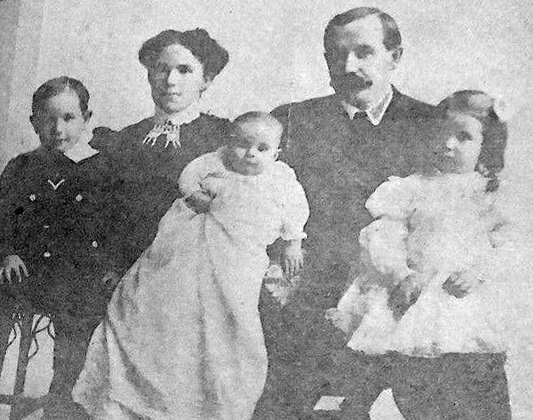
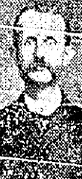
As Phillip H. Hoffman, director of the Alki History Project, tells us in his article “What’s in a Name?,” this street was named after Benjamin Wilton Baker (1860–1934), husband of Julia Curry Williams (1861–1950) and father of Marguerite Baker (1890–?), after whom SW Marguerite Court is named. The Bakers were proprietors of Rose Lodge, a summer resort which once stood where the eastern portion of SW Wilton Court is now.
Benjamin Wilton Baker, from the November 30, 1901, issue of The Seattle Times
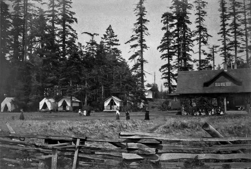
Rose Lodge and tents from beach, 1913
SW Wilton Court begins at SW Hinds Street across the street from the Bar-S Playground, and goes just over 700 feet southeast to 63rd Avenue SW between Beach Drive SW and SW Marguerite Court. It is a private right-of-way between 64th Avenue SW and 63rd Avenue SW.
Born and raised in Seattle, Benjamin Donguk Lukoff had his interest in local history kindled at the age of six, when his father bought him settler granddaughter Sophie Frye Bass’s Pig-Tail Days in Old Seattle at the gift shop of the Museum of History and Industry. He studied English, Russian, and linguistics at the University of Washington, and went on to earn his master’s in English linguistics from University College London. His book of rephotography, Seattle Then and Now, was published in 2010. An updated version came out in 2015.
This street, which is part of the unrecorded plat of B.W. Baker’s Rose Lodge Addition, was named after Marguerite Baker (1890–?), eldest daughter of Benjamin Wilton Baker (1860–1934) and Julia Curry Williams (1861–1950). The Bakers were proprietors of Rose Lodge, a summer resort which once stood where the subdivision is now.
The public right-of-way is a footpath that runs just over 300 feet from 63rd Avenue SW in the southeast to 64th Avenue SW in the northwest. Vehicular access to the homes is from a public alley to the north and a private one to the south.
Born and raised in Seattle, Benjamin Donguk Lukoff had his interest in local history kindled at the age of six, when his father bought him settler granddaughter Sophie Frye Bass’s Pig-Tail Days in Old Seattle at the gift shop of the Museum of History and Industry. He studied English, Russian, and linguistics at the University of Washington, and went on to earn his master’s in English linguistics from University College London. His book of rephotography, Seattle Then and Now, was published in 2010. An updated version came out in 2015.
W.T. Campbell was a long-time West Seattle resident living on the hillside above Alki. He was an early advocate for Alki annexation to the City of West Seattle, a real estate developer, early West Seattle school principal, banker, and a member of the Seattle City Council beginning 1924. He would serve as a city councilmember until 1929.
W.T. Campbell, from the October 11, 1933, issue of The Seattle Times
SW Campbell Place begins at SW Lander Street a block west of SW Admiral Way and goes just over 550 feet southwest to 56th Avenue SW at the north edge of Schmitz Park.
Born and raised in Seattle, Benjamin Donguk Lukoff had his interest in local history kindled at the age of six, when his father bought him settler granddaughter Sophie Frye Bass’s Pig-Tail Days in Old Seattle at the gift shop of the Museum of History and Industry. He studied English, Russian, and linguistics at the University of Washington, and went on to earn his master’s in English linguistics from University College London. His book of rephotography, Seattle Then and Now, was published in 2010. An updated version came out in 2015.
I first came across the Alki History Project while doing research for my article on SW Bronson Way. I’m not sure how I missed it before. The paper that mentioned Ira Bronson was “If at First You Don’t Succeed…,” a fascinating history of municipal governance and elections in West Seattle, and when I looked at their list of other papers I was thrilled to see among them “What’s in a Name?” — an investigation of Alki street names, both current and those changed long ago. Frater Avenue SW is the first of a number of posts in which I will be citing this paper, written by Phillip H. Hoffman, director of the project.
Frater Avenue SW originates in the 1955 plat of Anderson’s Soundview Terrace Addition № 2. Why Anderson, Caple, or Knowlton weren’t chosen instead for the honor (this being the only new street in the small subdivision, and those being the surnames of the three couples who filed the plat) isn’t clear. But, as Hoffman notes, SW Frater Street and SW Frater Place (both of which have since been vacated) were just to the west in the adjacent plat. In addition, an earlier Frater Avenue SW had existed, until it was vacated in 1942, just southeast of where today’s Frater Avenue begins at SW Spokane Street. The current Frater Avenue must have been named after one of these three streets.
But, of course, that leaves the question of who those three streets initially honored, and according to Hoffman,
Frater Avenue first appears in the plat Partition of Crawford Tract as ordered in King County Superior Court, Cause № 64110, June 17, 1915. [A.W.] Frater was the presiding judge.… The court commissioners assisting in the adjudication of a land title and ownership dispute before Judge Frater that resulted in the Crawford Tract plat probably named Frater Avenue in 1915, along with all the other streets appearing in the plat.
Archibald Wanless Frater (1856–1925), according to Cornelius Holgate in Seattle and Environs, was born in Ohio and came to Washington in 1888. Initially settling in Tacoma, he moved to Snohomish the next year and came to Seattle in 1898.
Judge Archibald Wanless Frater, from the front cover of The Seattle Mail & Herald, June 3, 1905
Today’s Frater Avenue SW begins at 57th Avenue SW just north of SW Hinds Street and goes ⅛ of a mile southeast to SW Spokane Street just west of 56th Avenue SW.
Born and raised in Seattle, Benjamin Donguk Lukoff had his interest in local history kindled at the age of six, when his father bought him settler granddaughter Sophie Frye Bass’s Pig-Tail Days in Old Seattle at the gift shop of the Museum of History and Industry. He studied English, Russian, and linguistics at the University of Washington, and went on to earn his master’s in English linguistics from University College London. His book of rephotography, Seattle Then and Now, was published in 2010. An updated version came out in 2015.
This West Seattle street was created in 1900 as part of the Replat of the West Seattle Land & Improvement Co’s. Third Plat. Originally Beach Way, it was renamed Bronson Way in 1907, when Seattle annexed West Seattle. Given that Ira Hull Bronson (1868–1930) was attorney for and vice president of the WSL&IC, it seems a fair assumption that it was named for him.
Ira Bronson, from his June 17, 1930, obituary in The Seattle Times. He had died the day before.
Bronson, a former president of the American Bar Association, was described in the June 18, 1930, issue of The Seattle Times as a “pioneer Seattle attorney and leader in admiralty circles… [who] was one of the founders of the Inland Navigation Company, which later became the Puget Sound Navigation Company.” (The PSNC’s domestic ferry routes were bought by the state in 1951, forming Washington State Ferries, and most of its Canadian routes became part of the new BC Ferries system in 1961. The firm, now known as the Black Ball Ferry Line, now runs one boat, the MV Coho, between Port Angeles and Victoria. Through a series of mergers, Bronson’s law firm is now Stoel Rives.)
Though the right-of-way begins further inland, SW Bronson Way only physically exists between Harbor Avenue SW and Elliott Bay. About 180 feet long, it is nearly 90 feet wide (quite a length-to-width ratio!) and essentially serves as a public parking lot. It is a shoreline street end, platted into the water, and features an unobstructed view of the city across the bay.
Born and raised in Seattle, Benjamin Donguk Lukoff had his interest in local history kindled at the age of six, when his father bought him settler granddaughter Sophie Frye Bass’s Pig-Tail Days in Old Seattle at the gift shop of the Museum of History and Industry. He studied English, Russian, and linguistics at the University of Washington, and went on to earn his master’s in English linguistics from University College London. His book of rephotography, Seattle Then and Now, was published in 2010. An updated version came out in 2015.
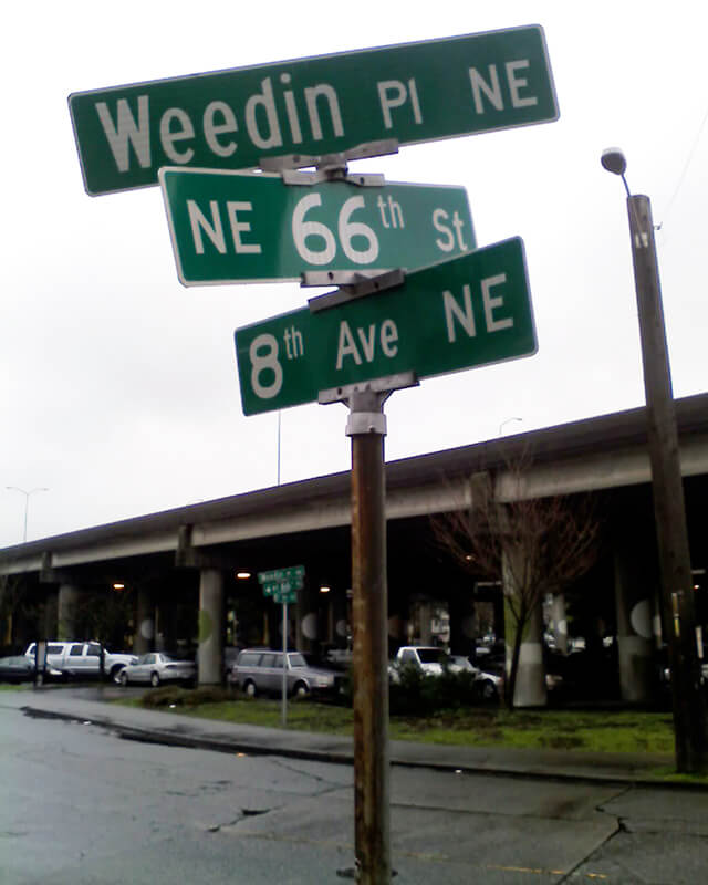
Originally Ravenna Avenue in the 1890 plat of the Woodlawn Addition to Green Lake, Weedin Place NE was named for the Weedin brothers, early settlers of the area. (Weedin’s Homestead Addition to the City of Seattle, filed by Robert Weedin, his son, and their wives in 1904, lies to the south; it would seem that when Ravenna Boulevard NE was established slightly to the west, Ravenna Avenue needed a new name, and that of the Weedins was chosen.)
In the fall of 1879, 10 years after the first homesteader arrived at Green Lake, a newly erected, simple log cabin schoolhouse opened its doors to 11 pupils.… This was the first Green Lake School.… The children came from four households on the east side of the lake: seven were sons and daughters of the brothers W. L. and Robert Weedin.… Thus began public school education in the territorial School District № 25.
And Valarie Bunn tells us on her blog, Wedgwood in Seattle History, that Robert Joseph Weedin (1842–1910) and William Luther Weedin (1845–1930) were Civil War veterans from Missouri who “did not have to take a full five years to ‘prove up a claim’ and be awarded ownership of land, according to the Homestead Act of 1862,” but could count their time in the service toward that total. Robert’s claim, as noted above, was southeast of Green Lake, while William’s was further east, in Wedgwood and Bryant.
A photograph of brothers W.L. and Robert Weedin that ran in the Seattle Post-Intelligencer, May 23, 1965, in an article about early schools in Green Lake
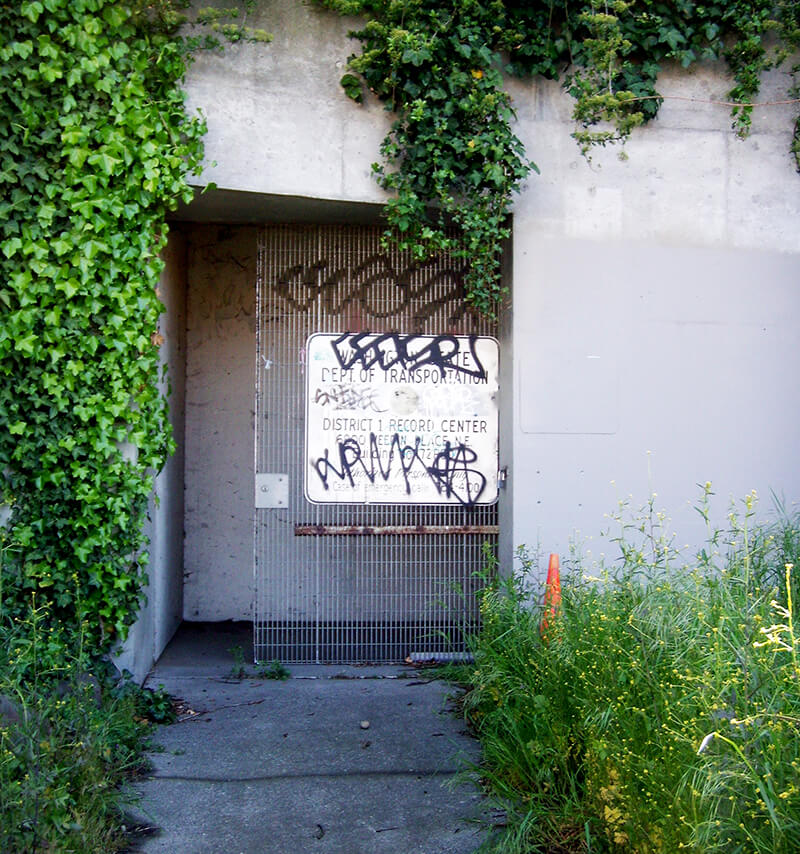
Today, Weedin Place NE begins at 5th Avenue NE and NE 70th Street and goes ¼ of a mile southeast to just past 8th Avenue NE and NE 66th Street, where the right-of-way becomes a park. It is notable for being the location of the Weedin Place fallout shelter, located under Interstate 5. Read more about it in “‘Lifeboat Ethics’ Under the Interstate: Seattle’s Prototype Highway Fallout Shelter,” by Washington State Department of Transportation historian Craig Holstine, who writes that
…The Weedin Place facility was apparently the first, and only, fallout shelter ever constructed in the U.S. under a public roadway. It was built under what would become Interstate 5 at the height of the Cold War in part as a way to demonstrate more effective uses of public rights-of-way.… The Commissioner of Public Roads… proposed putting shelters under the interstates as a way to save costs by combining needs of the national shelter and federal-aid highway programs and provide shelter for the traveling public.
Born and raised in Seattle, Benjamin Donguk Lukoff had his interest in local history kindled at the age of six, when his father bought him settler granddaughter Sophie Frye Bass’s Pig-Tail Days in Old Seattle at the gift shop of the Museum of History and Industry. He studied English, Russian, and linguistics at the University of Washington, and went on to earn his master’s in English linguistics from University College London. His book of rephotography, Seattle Then and Now, was published in 2010. An updated version came out in 2015.


.jpg)