This is the first honorary renaming we‘re covering on Writes of Way. It was named for the former “Mayor of Ballard,” Rob Mattson (1949–2018), the year after his death.
Honorary renamings differ from straight renamings in that:
They are done via resolution rather than ordinance
They do not replace the original street name in official records and addresses
They appear on brown, rather than green, signs
Speaking of signs, there appears to be some variation in their design; compare that of Rob Mattson Way, below, to that of Gerard Schwarz Place.
Rob Mattson Way covers 22nd Avenue NW between NW 56th Street and NW 57th Street.
Born and raised in Seattle, Benjamin Donguk Lukoff had his interest in local history kindled at the age of six, when his father bought him settler granddaughter Sophie Frye Bass’s Pig-Tail Days in Old Seattle at the gift shop of the Museum of History and Industry. He studied English, Russian, and linguistics at the University of Washington, and went on to earn his master’s in English linguistics from University College London. His book of rephotography, Seattle Then and Now, was published in 2010. An updated version came out in 2015.
In 2010, the portion of Airport Way S between 4th Avenue S and 6th Avenue S was renamed Seattle Boulevard S at the request of the adjacent property owners, restoring a name that disappeared from the map in 1931.
There were a series of roads following the semicircular curve of Elliott Bay from Downtown to the Duwamish River before the tideflats were filled in: first Beach Road (or River Road), then the Grant Street Bridge, which in turn became Seattle Boulevard once the fill was complete. Sometime before 1918… the portion of Seattle Boulevard that ran northeast–southwest (the southern third of the semicircle) was renamed Diagonal Avenue. (In 1931, the rest of Seattle Boulevard was renamed Airport Way.)
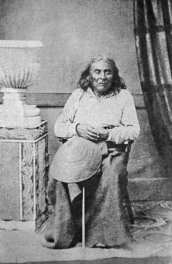
Seattle Boulevard was obviously named for the city, which itself was named after Si’ahl [siʔaɫ], better known in English as Chief Seattle of the Duwamish and Suquamish Tribes.
Since 2010, then, there have been two streets in the city that bear its and siʔaɫ’s name: Seattle Boulevard S and SW Seattle Street.
Born and raised in Seattle, Benjamin Donguk Lukoff had his interest in local history kindled at the age of six, when his father bought him settler granddaughter Sophie Frye Bass’s Pig-Tail Days in Old Seattle at the gift shop of the Museum of History and Industry. He studied English, Russian, and linguistics at the University of Washington, and went on to earn his master’s in English linguistics from University College London. His book of rephotography, Seattle Then and Now, was published in 2010. An updated version came out in 2015.
Today, Bernie Whitebear Way begins at Texas Way and Illinois Avenue and goes ½ a mile northwest, then west, to Daybreak Star.
Bernie Whitebear speaking to Senator Henry M. Jackson during the Daybreak Star lease signing ceremony, November 14, 1971. Courtesy of the Seattle Municipal Archives, Identifier 193058
Born and raised in Seattle, Benjamin Donguk Lukoff had his interest in local history kindled at the age of six, when his father bought him settler granddaughter Sophie Frye Bass’s Pig-Tail Days in Old Seattle at the gift shop of the Museum of History and Industry. He studied English, Russian, and linguistics at the University of Washington, and went on to earn his master’s in English linguistics from University College London. His book of rephotography, Seattle Then and Now, was published in 2010. An updated version came out in 2015.
Born Giovanni Domenicio Corgiat in Italy, John was a real estate investor who, according to his Seattle Times obituary, was also notable for “establish[ing] the Louvre Restaurant, the first French-Italian eating place in Seattle, in 1888.” (It was destroyed the next year in the Great Seattle Fire.) He was also apparently involved in a number of legal cases relating to the explusion of restaurateur John Cicoria from the Joseph Mazzini Society in 1907: not only the lawsuit demanding Cicoria’s reinstatement in the Italian-American fraternal organization, but one in which the society succeeded in making him pay its legal fees, and three libel suits — one which Cicoria won against Corgiat, and two which Corgiat filed against The Seattle Times and the Message-Vero-Italo-Americano with Cicoria as co-defendant in each. The suit against the Times was dismissed at Corgiat’s request; I haven’t been able to find any more information about the other.
John Corgiat, from his obituary in the Seattle Times, December 10, 1936
Originally Corgiat Street, S Corgiat Drive begins at the railroad tracks just east of Airport Way S and goes 300 feet northeast to just past Ursula Place S, at which point it turns northwest and becomes S Corgiat Drive (not in the original plat). From there, it goes ⅖ of a mile to S Albro Place, just west of Interstate 5.
Born and raised in Seattle, Benjamin Donguk Lukoff had his interest in local history kindled at the age of six, when his father bought him settler granddaughter Sophie Frye Bass’s Pig-Tail Days in Old Seattle at the gift shop of the Museum of History and Industry. He studied English, Russian, and linguistics at the University of Washington, and went on to earn his master’s in English linguistics from University College London. His book of rephotography, Seattle Then and Now, was published in 2010. An updated version came out in 2015.
This street, established in 1913 as Sturtevant Place, was named for real estate investor, banker, and antique store owner Cullen Kittredge Sturtevant (1865–1946), who developed a number of tracts in what is now Rainier Beach. Unlike many developers, he didn’t name this street after himself; it was added by the city nearly a decade after he filed Sturtevant’s Plat of Rainier Beach Acre Tracts.
Today, Sturtevant Avenue S begins at Rainier Avenue S between 51st Avenue S and 52nd Avenue S and goes ⅕ of a mile southeast to 52nd Avenue S and S Roxbury Street. Sturtevant Ravine, through which Mapes Creek runs on its way from Kubota Garden to Beer Sheva Park and Lake Washington, lies to its west.
Ad for Sturtevant’s Rainier Beach Lake Front Tracts, The Seattle Times, April 8, 1906
Born and raised in Seattle, Benjamin Donguk Lukoff had his interest in local history kindled at the age of six, when his father bought him settler granddaughter Sophie Frye Bass’s Pig-Tail Days in Old Seattle at the gift shop of the Museum of History and Industry. He studied English, Russian, and linguistics at the University of Washington, and went on to earn his master’s in English linguistics from University College London. His book of rephotography, Seattle Then and Now, was published in 2010. An updated version came out in 2015.
This street was created in 1900 as part of the plat of the Orchard Hill Addition, filed by Martin Dean, Sarah J. Dean, Elizabeth H. Lewis, William H. Lewis, the W.C. Hill Brick Company, and the First National Bank of Seattle. According to Don Sherwood, it was named for John J. Sturgus, “realtor and agent of [the] W.C. Hill Estate” (Hill had died in 1890).
I do find mentions of a John J. Sturgus, associated with the Hill Company or the Hill Estate, in a number of Polk directories. However, it appears a Dr. John J. Sturgus (1859–1907) was also the brother of Hill’s wife, born Alice Bradley Sturgus (1847–1904).
Article in the (Washington, D.C.) Evening Star, September 9, 1890, on the death of W.C. Hill, mentioning Mrs. Hill’s mother (“Mrs. Sturgus”) and brother (Dr. John J. Sturgus).
Given the unlikelihood of two completely different John J. Sturguses being associated with the Hills, I’m going to assume that the physician and real estate man were one and the same, and that the street was given its name either because Dr. Sturgus was Hill’s brother-in-law or because Sturgus was his wife’s maiden name (or both). If the latter, that puts it in the same category as Perkins Lane W, Thorndyke Avenue W, and Keen Way N.
Today, Sturgus Avenue S begins at S Charles Street, just east of the Jose Rizal Bridge, and goes ½ a mile southeast, then south, to S State Street. The right-of-way continues a block further, to the S Grand Street right-of-way, but houses with addresses on that block are accessed by a private alley north of 16th Avenue S.
Born and raised in Seattle, Benjamin Donguk Lukoff had his interest in local history kindled at the age of six, when his father bought him settler granddaughter Sophie Frye Bass’s Pig-Tail Days in Old Seattle at the gift shop of the Museum of History and Industry. He studied English, Russian, and linguistics at the University of Washington, and went on to earn his master’s in English linguistics from University College London. His book of rephotography, Seattle Then and Now, was published in 2010. An updated version came out in 2015.
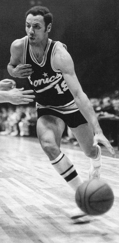
I’m not sure how I missed the news, but in December 2021 the block of Thomas Street between 1st Avenue N and 2nd Avenue N/Seattle Storm Way, just south of Climate Pledge Arena, was officially renamed Lenny Wilkens Way, after the Seattle basketball legend.
Leonard Randolph Wilkens (born 1937), who grew up in Brooklyn, New York, played basketball for the Seattle SuperSonics from 1968–1972, also serving as head coach from 1969–1972. He returned to coach the Sonics in 1977 and stayed until 1986, when he went to the Cleveland Cavaliers. He led the Sonics to two consecutive NBA championship games, in 1978 and 1979, the latter of which the Sonics won, giving Seattle its first national title since the Metropolitans won the Stanley Cup in 1917, and its last until 2004, when the Storm won the WNBA Championship. Wilkens finished his career as head coach of the New York Knicks in 2005. Through the Lenny Wilkens Foundation, which recently wound up operations, he also raised millions of dollars for Seattle Children’s Odessa Brown Children’s Clinic.
As far as I know, and please correct me if I’m wrong, this makes Lenny Wilkens only the second Black person to have a street named after him in Seattle, the first being Martin Luther King Jr.
At left, Lenny Wilkens in 1968; public domain photograph by Malcolm Emmons of The Sporting News. At right, Wilkens in 2013; public domain photograph by Technical Sergeant Samuel Morse, U.S. Air Force.
Born and raised in Seattle, Benjamin Donguk Lukoff had his interest in local history kindled at the age of six, when his father bought him settler granddaughter Sophie Frye Bass’s Pig-Tail Days in Old Seattle at the gift shop of the Museum of History and Industry. He studied English, Russian, and linguistics at the University of Washington, and went on to earn his master’s in English linguistics from University College London. His book of rephotography, Seattle Then and Now, was published in 2010. An updated version came out in 2015.
William Mortimer Lucas… was born in Illinois. Between 1908 and 1913 he was a speculative builder of houses in Seattle’s north end, houses that were financed by the sale of stock.… His office was located in the White Building in downtown Seattle. By 1912, the company was also selling plans for bungalows.
N Lucas Place begins at Stone Way N between N 40th Street and N 41st Street and goes about 375 feet east to Interlake Avenue N.
Born and raised in Seattle, Benjamin Donguk Lukoff had his interest in local history kindled at the age of six, when his father bought him settler granddaughter Sophie Frye Bass’s Pig-Tail Days in Old Seattle at the gift shop of the Museum of History and Industry. He studied English, Russian, and linguistics at the University of Washington, and went on to earn his master’s in English linguistics from University College London. His book of rephotography, Seattle Then and Now, was published in 2010. An updated version came out in 2015.
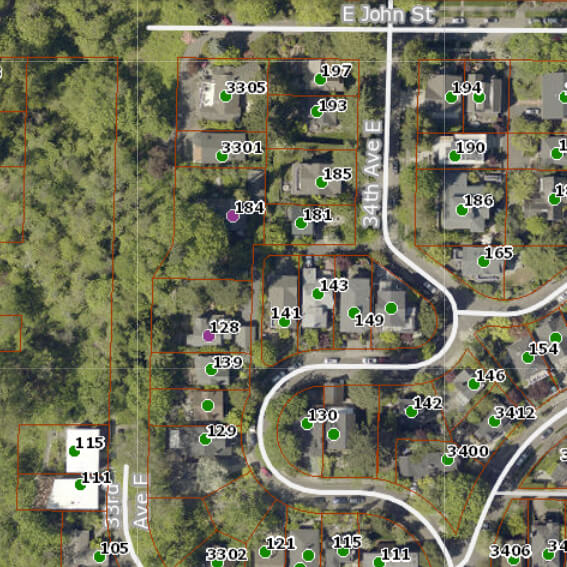
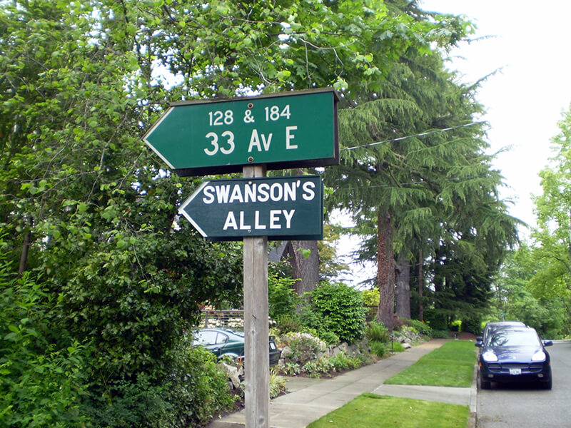
Officially, this alley off 34th Avenue E between E John Street and 35th Avenue E is unnamed. That proved inconvenient for Jack Sussman and Cathy Nunneley, who live at 184 and 128 33rd Avenue E, respectively. Yes, 33rd Avenue E, even though their house is accessed from 34th.
I don’t know how it works in other cities, but in Seattle, you can have an address on a nonexistent — or, more accurately, unimproved — street. This is the case with W Semple Street — the three residences with a Semple address are only accessible from 45th Avenue W. And this is the case here. Unlike Semple, 33rd Avenue E is improved… but not for the entire length of its right-of-way. From about 450 feet south of E Harrison Street to about 175 feet north of E Denny Way, 33rd Avenue E is unimproved and makes up part of the Harrison Ridge Greenbelt.
Swanson’s Alley and surrounding streets as shown on King County Parcel Viewer. Address points appear in green, except for 128 and 184 33rd Avenue E, which appear in purple.
We have a problem because our address is one that people cannot find. Get a new mailperson and we won’t see any mail for a week!… How many Roto-Rooter men, phone line fixers, and Craigslist contacts have been lost trying to find us? GPS and MapQuest systems are useless for locating my house. How many times have I run out to the street vainly searching for the delivery truck going round and round the neighborhood?
He goes on to explain that “a fine article lamenting [the] neglect of city alleys” written by Knute Berger inspired him to put up a sign reading “Swanson’s Alley” underneath the city’s official sign directing people to his and Nunneley’s houses. He chose the name to honor “Swanson, a Swedish carpenter, [who] lived here in the 1930s,” and happily reports that giving the alley a name, albeit unofficial, did indeed help people find his residence.
In the next issue of The Valley View, Sussman reports that he was able to locate a grandson of this Swanson, to give him the news and get further details on the alley’s namesake:
The grandfather who founded the family here was Elof Svenson [1881–1958]; the name later became Swanson in America. Elof was a teenage laborer, a Swedish immigrant who spoke little English. I had one detail wrong: he was not a carpenter but a landscape worker who specialized in rockeries. He put in all the bulkheads that hold the ground above the Harrison Greenbelt.
In general, I’m not a fan of unofficial signage (especially signs proclaiming public rights-of-way to be private, which I’ve come across in Blue Ridge, Montlake, and Wedgwood) but I have no problem with this one. It doesn’t imply private ownership and it’s meant to improve navigation. And it honors someone most people would otherwise never have heard of.
By the way — in case you’re wondering why Swanson’s Alley shows up in Google Maps and OpenStreetMap even though the name is unofficial, it’s because I added it. The name, that is — the alley was already present on both. (I’m trying to get it added to Apple Maps as well, but that may be a bit more difficult.)
Born and raised in Seattle, Benjamin Donguk Lukoff had his interest in local history kindled at the age of six, when his father bought him settler granddaughter Sophie Frye Bass’s Pig-Tail Days in Old Seattle at the gift shop of the Museum of History and Industry. He studied English, Russian, and linguistics at the University of Washington, and went on to earn his master’s in English linguistics from University College London. His book of rephotography, Seattle Then and Now, was published in 2010. An updated version came out in 2015.
This cul-de-sac, which goes just about 375 feet northwest from SW Donovan Street between 41st Avenue SW and 42nd Avenue SW, was created as part of the Robert E. Thomas Addition in 1959. Its original name was Fauntlee Place SW, but this was changed in 1963, presumably to avoid confusion with the nearby Fauntlee Crest SW. (No confusion was anticipated with the nearby Vashon Place SW, it seems.) Like Vashon Place, it is named after Vashon Island, located 4 miles to the southwest, across Puget Sound. The island itself was named for Royal Navy Admiral James Vashon by his friend, Royal Navy Captain George Vancouver, in 1792.
Unlike Vashon Place SW, Vashon View SW actually has a view of Vashon Island, though not the one you see below!
Born and raised in Seattle, Benjamin Donguk Lukoff had his interest in local history kindled at the age of six, when his father bought him settler granddaughter Sophie Frye Bass’s Pig-Tail Days in Old Seattle at the gift shop of the Museum of History and Industry. He studied English, Russian, and linguistics at the University of Washington, and went on to earn his master’s in English linguistics from University College London. His book of rephotography, Seattle Then and Now, was published in 2010. An updated version came out in 2015.
Two real estate firms, F.W. Keen Company and J.L. Grandey, Inc., organized most of the racial restrictive covenants for Queen Anne from 1928 to 1931… specifying that “No person or persons of Asiatic, African or Negro blood, lineage, or extraction shall be permitted to occupy a portion of said property, or any building thereon; except domestic servants may actually and in good faith be employed by white occupants of such premises.”
In addition to being president of F.W. Keen, George Morford was vice president of J.L. Grandey.
Which Keen was honored by Keen Way N — Gertrude Alice Keen Morford, Frederick Walter Keen, or the F.W. Keen Company — isn’t clear; if it was for George Morford’s wife, that would put Keen Way in the same category as Perkins Lane W and Thorndyke Avenue W.
Keen Way N begins at Aurora Avenue N between W Green Lake Drive N and Winona Avenue N and goes ⅕ of a mile northeast to N 76th Street.
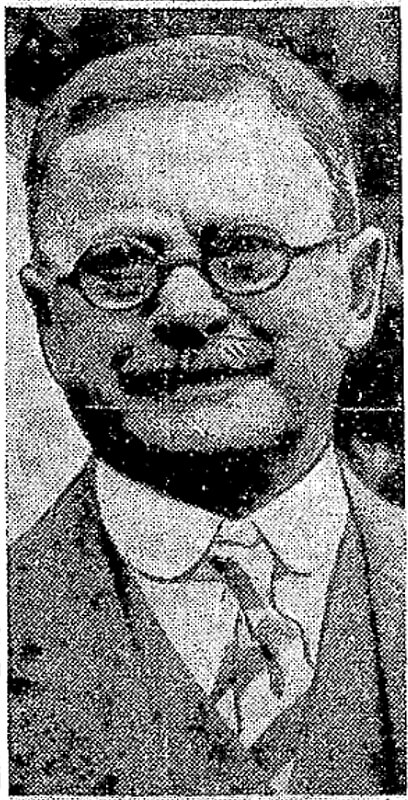
Frederick Walter Keen, from his Seattle Times obituary, August 14, 1929. I was unable to locate a photograph of his daughter, Gertrude.
Born and raised in Seattle, Benjamin Donguk Lukoff had his interest in local history kindled at the age of six, when his father bought him settler granddaughter Sophie Frye Bass’s Pig-Tail Days in Old Seattle at the gift shop of the Museum of History and Industry. He studied English, Russian, and linguistics at the University of Washington, and went on to earn his master’s in English linguistics from University College London. His book of rephotography, Seattle Then and Now, was published in 2010. An updated version came out in 2015.
This street, originally W 93rd Street in the 1907 plat of Loyal Heights, filed by Edward B. Cox, Harry Whitney Treat (1865–1922), and Treat’s wife, Olive Marion Graef Treat (1869–1945), appears to honor Harry’s middle name, which was also part of his mother’s name and was his grandmother’s maiden name. It begins at View Avenue NW and 32nd Avenue NW and goes just under 300 feet northeast to NW 95th Street.
Born and raised in Seattle, Benjamin Donguk Lukoff had his interest in local history kindled at the age of six, when his father bought him settler granddaughter Sophie Frye Bass’s Pig-Tail Days in Old Seattle at the gift shop of the Museum of History and Industry. He studied English, Russian, and linguistics at the University of Washington, and went on to earn his master’s in English linguistics from University College London. His book of rephotography, Seattle Then and Now, was published in 2010. An updated version came out in 2015.
This street is named for Milton Densmore (1839–1908), a Civil War veteran from Chelsea, Vermont, who, according to Clarence Bagley’s History of Seattle from the Earliest Settlement to the Present Time, fought in the Battles of Fairfax Court House, Gettysburg, and Rappahannock Station. He returned to Vermont after the war, then moved to Beloit, Wisconsin, in 1867. Densmore came to Seattle in 1871. Sophie Frye Bass relates in Pig-tail Days in Old Seattle that he started out as “one of the captains of the Linna C. Gray, the stocky barge that carried coal from shore to shore in Lake Union.” In 1875, he opened a grocery, which closed in 1887. Bagley adds that
With various interests of Seattle he was closely associated. He laid the first steel rail for the street car system of Seattle, wooden rails having been used previous to that time. He served for two terms as a member of the city council and exercised his official prerogatives in support of various plans and measures for the general good. He served for seven years as a member of the school board and the cause of education found in him a stalwart champion. Densmore Avenue of Seattle was named in his honor and Seattle in many ways acknowledges her indebtedness to him. He did much toward improving property, built residences and otherwise aided in enhancing the attractiveness of the city and at all times was public spirited and active.
Milton Densmore, from the November 10, 1907, issue of the Seattle Post-Intelligencer. The story was about his reunion with his brother, Jason Densmore, whom he hadn’t seen in over four decades, since the Civil War ended (Jason was likewise a Union soldier from Vermont).
Densmore Avenue N begins at N Northlake Way, just north of Gas Works Park. It then goes ¾ of a mile north to the Wallingford Playfield at N 42nd Street. Resuming a block north, it goes a further ⅖ of a mile to N 50th Street. It picks up again at the north end of Green Lake, where Green Lake Drive N splits into W Green Lake Drive N and E Green Lake Drive N, and goes ⅗ of a mile to Cascadia Elementary School at N 90th Street. Densmore resumes at N 92nd Street and goes another ⅗ of a mile, past Licton Springs Park, to Mineral Springs Park at N 105th Street. It picks up again just north of N Northgate Way for a couple blocks before being stopped by Evergreen–Washelli Cemetery and UW Medical Center – Northwest. After a short segment north of the hospital, it then forms part of the ring arterial around Haller Lake, going ⅓ of a mile from N 122nd Street to N 128th Street, and finishes up with a ½-mile-long segment from Ingraham High School at N 135th Street to the city limits at N 145th Street. (As with many other North Seattle avenues, the name continues on into Shoreline; its northernmost appearance is between N 202nd Place and N 203rd Place, just south of the King–Snohomish county line at N 205th Street.)
Born and raised in Seattle, Benjamin Donguk Lukoff had his interest in local history kindled at the age of six, when his father bought him settler granddaughter Sophie Frye Bass’s Pig-Tail Days in Old Seattle at the gift shop of the Museum of History and Industry. He studied English, Russian, and linguistics at the University of Washington, and went on to earn his master’s in English linguistics from University College London. His book of rephotography, Seattle Then and Now, was published in 2010. An updated version came out in 2015.
This street is named for Peter Wickstrom (1837–1915), who immigrated to the United States from Sweden in the late 1860s. According to Thomas Ostenson Stine’s Scandinavians on the Pacific, Puget Sound, he lived in St. Paul, Minnesota, and Portland, Oregon, before coming to Seattle. His obituary, which ran in The Seattle Times on January 15, 1915, the day after his death, reads in part:
Peter Wickstrom, well-known pioneer of Seattle and an extensive realty holder, died unexpectedly yesterday afternoon after leaving the dinner table at his residence near Alki Point.… The deceased made his home at “The Old Homestead,” a tract of land not far from Alki Point.… Wickstrom came to this city in 1873 and conducted a hotel prior to the fire of 1889. Subsequent to that time he had not engaged actively in business.
Peter Wickstrom, from his Seattle Times obituary
Wickstrom Place SW begins at 54th Place SW just south of Alki Avenue SW and goes around 500 feet south to a dead end.
The Peter Wickstrom tract in Baist’s 1912 atlas of Seattle
The Peter Wickstrom tract in Kroll’s 1920 atlas of Seattle
Peter Wickstrom’s 7.18-acre tract before and after his death.
Born and raised in Seattle, Benjamin Donguk Lukoff had his interest in local history kindled at the age of six, when his father bought him settler granddaughter Sophie Frye Bass’s Pig-Tail Days in Old Seattle at the gift shop of the Museum of History and Industry. He studied English, Russian, and linguistics at the University of Washington, and went on to earn his master’s in English linguistics from University College London. His book of rephotography, Seattle Then and Now, was published in 2010. An updated version came out in 2015.
Born and raised in Seattle, Benjamin Donguk Lukoff had his interest in local history kindled at the age of six, when his father bought him settler granddaughter Sophie Frye Bass’s Pig-Tail Days in Old Seattle at the gift shop of the Museum of History and Industry. He studied English, Russian, and linguistics at the University of Washington, and went on to earn his master’s in English linguistics from University College London. His book of rephotography, Seattle Then and Now, was published in 2010. An updated version came out in 2015.
Matilda and Nelson Chilberg. Her photo is from the July 17, 1927, issue of the The Seattle Times; his is from the December 15, 1928, issue of the Seattle Post-Intelligencer.
Chilberg Avenue SW begins at 59th Avenue SW and SW Carroll Street and goes ⅕ of a mile southeast to SW Genessee Street just east of Beach Drive SW at the Emma Schmitz Memorial Overlook and Me-Kwa-Mooks Park.
Born and raised in Seattle, Benjamin Donguk Lukoff had his interest in local history kindled at the age of six, when his father bought him settler granddaughter Sophie Frye Bass’s Pig-Tail Days in Old Seattle at the gift shop of the Museum of History and Industry. He studied English, Russian, and linguistics at the University of Washington, and went on to earn his master’s in English linguistics from University College London. His book of rephotography, Seattle Then and Now, was published in 2010. An updated version came out in 2015.
This West Seattle street is really more of a footpath, being narrow, unpaved, and closed to motor vehicles. The public right-of-way runs about 450 feet northwest from Bonair Drive SW as it descends through the Duwamish Head Greenbelt from Sunset Avenue SW to Alki Avenue SW, and the path continues for some 1,150 feet more through property owned by the parks department.
Clarmar Place SW was created in 1941 as part of the plat of Clarmar Crags, which name appears to be a combination of Clara Coumbe (died 1975?), landowner, and mar, for its location above Elliott Bay and Puget Sound.
Born and raised in Seattle, Benjamin Donguk Lukoff had his interest in local history kindled at the age of six, when his father bought him settler granddaughter Sophie Frye Bass’s Pig-Tail Days in Old Seattle at the gift shop of the Museum of History and Industry. He studied English, Russian, and linguistics at the University of Washington, and went on to earn his master’s in English linguistics from University College London. His book of rephotography, Seattle Then and Now, was published in 2010. An updated version came out in 2015.
S Delappe Place begins at the end of 27th Avenue S, south of S Horton Street, and goes around 175 feet west to a dead end at the Cheasty Boulevard greenspace.
Born and raised in Seattle, Benjamin Donguk Lukoff had his interest in local history kindled at the age of six, when his father bought him settler granddaughter Sophie Frye Bass’s Pig-Tail Days in Old Seattle at the gift shop of the Museum of History and Industry. He studied English, Russian, and linguistics at the University of Washington, and went on to earn his master’s in English linguistics from University College London. His book of rephotography, Seattle Then and Now, was published in 2010. An updated version came out in 2015.
This street originates in the 1907 plat of Cascade View Addition to the City of Seattle, King County, Washington. Originally Della Street, it appears to have been renamed for William Gordon Anthony and his wife, C. Nana Anthony, who filed the plat. William, who died June 8, 1925, at the age of 64, had been working in insurance and real estate since 1910, according to his obituary in the June 10 issue of The Seattle Times. In it, his wife’s name is given as Canana, not C. Nana, as the plat has it. (Curiously, her own death certificate [she died November 6 of the same year at the age of 57] gives her name as C. Nanny!)
Anthony Place S begins at 27th Avenue S just south of S Walden Street and S Della Street and goes less than 100 feet southwest before turning into a private driveway, which turns into an alley, which turns into another private driveway that connects to Cheasty Boulevard S. The undeveloped right-of-way continues southwest for another ⅐ of a mile.
Born and raised in Seattle, Benjamin Donguk Lukoff had his interest in local history kindled at the age of six, when his father bought him settler granddaughter Sophie Frye Bass’s Pig-Tail Days in Old Seattle at the gift shop of the Museum of History and Industry. He studied English, Russian, and linguistics at the University of Washington, and went on to earn his master’s in English linguistics from University College London. His book of rephotography, Seattle Then and Now, was published in 2010. An updated version came out in 2015.
This street was created in 1924 as part of Mayes’ Addition to the City of Seattle, filed by Wilbur Mayes (1871–1949); his wife, May H. Stutz Mayes (1870–1948); and George Moore. According to the reports of their deaths in The Seattle Times, on October 5, 1949, and October 14, 1948, respectively, the Mayeses were married in 1896 and lived in the Philippines, where Wilbur was a lumberman, from 1905 to 1912. They moved from the Philippines to Seattle, where he became an accountant. He apparently became a house repairman after retirement, and died after falling 15 feet from a University District neighbor’s roof.
Interestingly, it appears on the plat map as Mayes’ Court, with the apostrophe, but its official name lacks the punctuation, as do, I believe, all Seattle streets. (We have no streets named O’Brien, O’Reilly, O’Sullivan, or the like; I suppose an exception would have been made in such cases.)
Mayes Court S begins at S Carver Street and goes about 350 feet northwest to a cul-de-sac.
Born and raised in Seattle, Benjamin Donguk Lukoff had his interest in local history kindled at the age of six, when his father bought him settler granddaughter Sophie Frye Bass’s Pig-Tail Days in Old Seattle at the gift shop of the Museum of History and Industry. He studied English, Russian, and linguistics at the University of Washington, and went on to earn his master’s in English linguistics from University College London. His book of rephotography, Seattle Then and Now, was published in 2010. An updated version came out in 2015.


.jpg)
.jpg)