Cowen Place NE

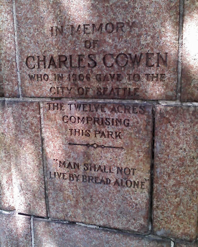
This street was created as part of the 1906 plat of Cowen’s University Park, filed by the Sylvester-Cowen Investment Company, of which Charles Cowen (1869–1926) was president. Originally Ravenna Place, it received its current name in 1918, according to an article in the January 29 issue of The Seattle Times. (This article also reported that the names of the individual streets that made up Queen Anne Boulevard would be restored and that Oriental Avenue [counterpart of the still-existing Occidental Avenue S] would become Third Avenue S). Whether it honors Cowen or the park named after him, which he donated to the city in 1906, is unclear.

Article in September 22, 1917, issue of The Seattle Times on Charles Cowen and his bounty on German leaders during World War I

Cowen was born in England, moved with his family to South Africa, and came to the United States in 1890, arriving in Seattle in 1900. Dotty DeCoster writes for HistoryLink.org:

Cowen was, by many accounts, a lively and active participant in developing the University District. According to architectural historian Shirley L. Courtois, he was British and had grown up in South Africa, where his family members were diamond miners and merchants. In 1890 he was sent to New York to purchase equipment for the mines. He never returned to South Africa. He apparently broke with his family, changed his name from Cohen to Cowen, and settled first in New York State, then in Florida, and finally in Seattle. Cowen reportedly retained a distinctively English style throughout his life.

The facts that his surname was originally Cohen and that his family was involved in diamond mining in South Africa led me to think he must have been Jewish, but I could find no definitive mention of his ethnicity online. However, in the March 19, 1926, issue of The Seattle Times, I found an article on the probate of his will, which mentioned that $2,000 of his $50,000 estate would go to the Hebrew Benevolent Society (today known as Jewish Family Service). That makes Cowen and Henry Fuhrman (1844–1907) (Fuhrman Avenue E) the only Jews I am aware of who have Seattle streets named after them. (Note added November 9, 2024: Now there’s a third: Sue Bird [born 1980] [Sue Bird Court N]).

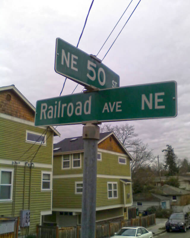
Cowen Place NE begins at NE Ravenna Boulevard and University Way NE and goes just over 325 feet northeast to 15th Avenue NE, at the south end of the Cowen Park Bridge.

Detail of Charles Cowen memorial at entrance to Cowen Park
Detail of Charles Cowen memorial at entrance to Cowen Park, June 1, 2009. “In memory of Charles Cowen who in 1906 gave to the city of Seattle the twelve acres comprising this park. ‘Man shall not live by bread alone.’” Photograph by Benjamin Lukoff. Copyright © 2009 Benjamin Lukoff. All rights reserved.
Signs at corner of NE Ravenna Boulevard, University Way NE, and Cowen Place NE, August 24, 2009
Signs at corner of NE Ravenna Boulevard, University Way NE, and Cowen Place NE, August 24, 2009. Photograph by Benjamin Lukoff. Copyright © 2009 Benjamin Lukoff. All rights reserved.

Fauntlee Crest SW

This street was created in 1955 as 43rd Avenue SW in the plat of Fauntlee Hills Division № 5. It received its current name in 1959. “Faunt” is an obvious reference to the greater Fauntleroy neighborhood, and Fauntlee Hills was developed on the western slope of the hill that rose up from Fauntleroy Cove, but I’m not sure where “lee” comes from. (I was thinking, perhaps, from “leeward,” but prevailing winds in Seattle are from the southwest, meaning this is the windward, not leeward, side of the hill. Perhaps Arthur C. Webb, the developer, simply thought it sounded euphonious.)

Like its neighbor Vashon View SW (which was originally named Fauntlee Place SW!), this appears to be the only crest in the city. (The USPS abbreviates these as CRST, while its Seattle street sign abbreviation is Cr.)

Fauntlee Crest SW begins at SW Concord Street and California Avenue SW and goes ¼ mile north to a dead end.

Fauntlee Hills Ad in the November 1, 1953, Seattle Times
Advertisement for Fauntlee Hills in the November 1, 1953, issue of The Seattle Times

Rainier Avenue S

This street follows the route of the Rainier Avenue Electric Railway Company’s Seattle-to-Renton line, which began to be built in 1891. Both the rail line and street were named for Mount Rainier (təqʷubəʔ), itself named by Captain George Vancouver for his friend, Royal Navy Rear Admiral Peter Rainier (1741–1808). As the Seattle Post-Intelligencer noted on September 3, 1890, “the avenue points straight toward Mount Rainier, which mountain will be in plain view all the way.”

Rainier Avenue S begins at the intersection of S Jackson Street, Boren Avenue S, and 14th Avenue S, and goes nearly 8 miles southeast to the city limits. From there, it continues around 3¾ miles south to the intersection of Interstate 405 and State Route 167 in Renton.

Looking south on Rainier Avenue S from S Jackson Street, with Mount Rainier in background, and two Metro route 7 buses, July 2011. From https://flickr.com/photos/95482862@N00/5914713222
Looking south on Rainier Avenue S from S Jackson Street. “The mountain is out” on this July 2011 day. Metro route 7 trolleybuses follow the route of the old interurban from here to 57th Avenue S. Photograph by Flickr user Oran Viriyincy, licensed under Creative Commons Attribution-ShareAlike 2.0 Generic
Aerial view of Rainier Valley looking north, 2001
Aerial view of Rainier Valley, Beacon Hill, and Downtown, May 22, 2001. Rainier Avenue S is the tree-lined street running up the middle of the photograph. Courtesy of the Seattle Municipal Archives, Identifier 114373.

NW Carkeek Park Road

This street was named for Carkeek Park, which encompasses 216 acres in the Broadview neighborhood, including Pipers Creek and nearly ½ a mile of Puget Sound waterfront (though the usable beach is much shorter, as the main line of the BNSF Railway cuts off public access to the rest). It was one of the “46 new street names to simplify street addresses” The Seattle Times reported on in its issue November 6, 1960, and was made up of “Sixth Avenue Northwest from West 110th to West 111th Streets, West 111th Street from Sixth to Seventh Avenues Northwest, Seventh Avenue NW from West 111th to West 114th Streets, and West 114th Street from Seventh Avenue NW to West 116th Street.” (Part of this route was once Puget Drive, part of the 1911 View-Lands Addition.)

The park itself opened in 1929 and was named for Morgan James Carkeek (1847–1931) and his wife, Emily Gaskill Carkeek (1852–1926). According to the Museum of History & Industry, “Morgan… was an accomplished stonemason and successful building contractor who built several of Seattle’s early stone buildings, such as the Dexter Horton Bank, and large office buildings, including the Burke and Haller buildings.” In 1918, he and Emily donated land to the city for the first Carkeek Park, located along Lake Washington where Magnuson Park is today, but soon thereafter plans were made to develop Naval Air Station Seattle on the land, and the park was taken over by the Navy in 1926. The Carkeeks donated $25,000 to the city to purchase land elsewhere, and with the addition of $100,000 in public funds the city was able to buy Piper’s Canyon.

Report in The Seattle Times, May 28, 1927, on the Carkeeks' contribution of funds to buy Piper's Canyon
Report in The Seattle Times, May 28, 1927, on the Carkeeks’ contribution of funds to buy Piper’s Canyon. The Seattle Historical Society, which they had a hand in founding, never did build a museum in Carkeek Park, but ended up building the Museum of History & Industry in Montlake’s McCurdy Park instead. MOHAI opened in 1952 and moved to Lake Union Park in 2012 after having to make way for the expansion of Washington State Route 520.

NW Carkeek Park Road begins at NW 110th Street and Puget Drive NW and winds ½ a mile northwest to the entrance to Carkeek Park at NW 114th Street. Within the park, it goes a further ½ mile west, ending at a parking lot, picnic area, and playground. (This portion appears to have once been known as Piper’s Canyon Road or Pipers Road.) From here, there is a bridge over the BNSF Railway tracks to a beach along Puget Sound and the mouth of Pipers Creek.

Aerial view of Carkeek Park, 1969
Aerial view of Carkeek Park, looking southeast, July 9, 1969. The valley and outlet of Pipers Creek are clearly visible, as is the main line of the BNSF Railway that separates the park’s wooded and grassy areas from Puget Sound. Courtesy of the Seattle Municipal Archives, Identifier 77628.

Seola Beach Drive SW

According to Seattle parks historian Don Sherwood’s sheet on Seola Park, this street began as a logging railroad. It was then replaced by the Charles Arey county road (“recently surveyed,” according to an article in the August 26, 1893, Seattle Post-Intelligencer), which was renamed Qualheim Road in 1914 by Carl Olsen Qualheim. It received its current name in 1956 when that portion of Arbor Heights was annexed to Seattle. “Seola” itself was the product of a naming contest:

In 1893, a family named Kakeldy built the first home on the beach.… Before long, children in the vicinity school referred to residents of Kakeldy Beach as the “Cackilty Chickens.”… In 1910 the beach residents sponsored a renaming contest which was won by Mel Miller, friend of the school’s teacher of Spanish, Agnes Quigley; his suggestion: “Se-ola = to know the wave.”

Seola Beach Drive SW begins at SW 106th Street between 28th Avenue SW and 31st Avenue SW and goes ⅞ of a mile south, then southwest, to a dead end at the beach, just past SW Seola Lane.

For its entire length, Seola Beach Drive SW forms the southern city limits of Seattle, separating it from Burien and unincorporated King County (White Center). (Unlike the northern city limits, formed by 145th Street, Seattle’s southern city limits are jagged. If they went due east from Seola Beach, Seattle would encompass large portions of Burien, Tukwila, and Renton; whereas if they followed a parallel set at the city limits’ northernmost point, everything south of Kenyon Street [approximately the north end of the South Park Bridge] would be lost to Seattle.)

Sign reading Privately Owned Beaches, No Public Access at Seola Beach
Seola Beach, April 8, 2011. Unfortunately, this is not a case where a street was platted into the water, creating a shoreline street end; the right-of-way explicitly ends at the fence, and this portion of the beach belongs to the property owners to the south. Photograph by Flickr user NabeWise, licensed under Creative Commons Attribution 2.0 Generic

SW Teig Place

According to Phillip H. Hoffman, director of the Alki History Project, in his paper “What’s in a Name?,” SW Teig Place was created in 1916 as part of the Olson Land Company’s 3rd Addition to Seattle. At the time, Jacob Larson Teig (1865–1945) was vice president of Olson Land. He was also the husband of Clara Isabelle Olson (1864–1944), daughter of Knud Olson (1830–1919), who had platted Alki Point in 1891.

SW Teig Place begins at 57th Avenue SW just north of SW Stevens Street and goes around 450 feet northeast to 56th Avenue SW just north of SW Lander Place.

Frater Avenue SW

I first came across the Alki History Project while doing research for my article on SW Bronson Way. I’m not sure how I missed it before. The paper that mentioned Ira Bronson was “If at First You Don’t Succeed…,” a fascinating history of municipal governance and elections in West Seattle, and when I looked at their list of other papers I was thrilled to see among them “What’s in a Name?” — an investigation of Alki street names, both current and those changed long ago. Frater Avenue SW is the first of a number of posts in which I will be citing this paper, written by Phillip H. Hoffman, director of the project.

Frater Avenue SW originates in the 1955 plat of Anderson’s Soundview Terrace Addition № 2. Why Anderson, Caple, or Knowlton weren’t chosen instead for the honor (this being the only new street in the small subdivision, and those being the surnames of the three couples who filed the plat) isn’t clear. But, as Hoffman notes, SW Frater Street and SW Frater Place (both of which have since been vacated) were just to the west in the adjacent plat. In addition, an earlier Frater Avenue SW had existed, until it was vacated in 1942, just southeast of where today’s Frater Avenue begins at SW Spokane Street. The current Frater Avenue must have been named after one of these three streets.

But, of course, that leaves the question of who those three streets initially honored, and according to Hoffman,

Frater Avenue first appears in the plat Partition of Crawford Tract as ordered in King County Superior Court, Cause № 64110, June 17, 1915. [A.W.] Frater was the presiding judge.… The court commissioners assisting in the adjudication of a land title and ownership dispute before Judge Frater that resulted in the Crawford Tract plat probably named Frater Avenue in 1915, along with all the other streets appearing in the plat.

Archibald Wanless Frater (1856–1925), according to Cornelius Holgate in Seattle and Environs, was born in Ohio and came to Washington in 1888. Initially settling in Tacoma, he moved to Snohomish the next year and came to Seattle in 1898.

Archibald Wanless Frater
Judge Archibald Wanless Frater, from the front cover of The Seattle Mail & Herald, June 3, 1905

Today’s Frater Avenue SW begins at 57th Avenue SW just north of SW Hinds Street and goes ⅛ of a mile southeast to SW Spokane Street just west of 56th Avenue SW.

Railroad Avenue NE

This street was created in 1946 by Ordinance 75507, “an ordinance accepting a deed from Eva M. Barquist, a spinster, to the City of Seattle for street purposes and laying off East 50th Street and Railroad Avenue Northeast.” This restored the Railroad Avenue NE name to a very short street on the east side of the Northern Pacific tracks, six years after it was changed to NE Blakely Street on the west side.

Railroad Avenue NE begins at NE 50th Street just east of 39th Avenue NE and goes 90 feet south to a dead end, essentially serving as a driveway for a cluster of townhouses.

Sign at corner of NE 50th Street and Railroad Avenue NE, February 3, 2011
Sign at corner of NE 50th Street and Railroad Avenue NE, February 3, 2011. Photograph by Benjamin Lukoff. Copyright © 2011 Benjamin Lukoff. All rights reserved.

Airport Way S

Airport Way S does not, as one might expect, go from the city to Seattle–Tacoma International Airport (known to locals as Sea–Tac), but rather to King County International Airport (better known as Boeing Field). It got its current name in 1931 at the request of the Georgetown-South Seattle Improvement Club, which, according to an article in the April 12 issue of The Seattle Times,

…asked the City Council to merge portions of Seattle Boulevard, Eighth and Ninth Avenues South and Duwamish Avenue, leading from the central business area to Boeing Field, into a new highway, to be known as Airport Way.… [They contended] that strangers are confused in efforts to find the airport by lack of any specifically designated street leading to it.

Seattle Boulevard originated as

The Beach or River Road… [which] skirted the shore of the bay at the foot of the high Beacon Hill bluff, east of what is now Airport Way, and ran south along the Duwamish.… Built in the early fifties, [it] was a hard road to keep in good condition.… In 1886, a road was built on piling over the mud flats a little west of the Beach Road to avoid the slides and floods. This street became known as the Grant Street Bridge.

Sophie Frye Bass, Pig-Tail Days in Old Seattle

I elaborate in Diagonal Avenue S that

Essentially, there were a series of roads following the semicircular curve of Elliott Bay from Downtown to the Duwamish River before the tideflats were filled in: first Beach Road (or River Road), then the Grant Street Bridge, which in turn became Seattle Boulevard once the fill was complete. Sometime before 1918… the portion of Seattle Boulevard that ran northeast–southwest (the southern third of the semicircle) was renamed Diagonal Avenue. (In 1931, the rest of Seattle Boulevard was renamed Airport Way.)

View from Beacon Hill looking northwest over Grant Street Bridge and Elliott Bay tideflats, circa 1900
This photograph, taken circa 1900 by Anders Beer Wilse, looks northwest from Beacon Hill over the Grant Street Bridge and the Elliott Bay tideflats. At upper left is West Seattle; at upper right is Magnolia. From this perspective, Downtown Seattle appears just below Magnolia. Bainbridge Island is in the distance across Puget Sound.

Once Sea–Tac fully opened in 1949, Airport Way S no longer led to the region’s primary airport, which was more directly reached via U.S. 99, but no further name changes took place.

Today, Airport Way S begins at Seattle Boulevard S and 6th Avenue S and goes 6⅗ miles southeast, then south, then southeast again, ending at Boeing Access Road. Its lower 2½ miles parallel the eastern boundary of Boeing Field.

Boeing Field aerial
Aerial of Boeing Field, looking northwest, December 2014. In the foreground is Interstate 5; just to the west are the BNSF Railway tracks, then Airport Way S, then Perimeter Road S. Photograph by Wikimedia Commons user Bernstea, licensed under Creative Commons Attribution-Share Alike 4.0 International

Seattle Boulevard S

In 2010, the portion of Airport Way S between 4th Avenue S and 6th Avenue S was renamed Seattle Boulevard S at the request of the adjacent property owners, restoring a name that disappeared from the map in 1931.

As I explain in Diagonal Avenue S,

There were a series of roads following the semicircular curve of Elliott Bay from Downtown to the Duwamish River before the tideflats were filled in: first Beach Road (or River Road), then the Grant Street Bridge, which in turn became Seattle Boulevard once the fill was complete. Sometime before 1918… the portion of Seattle Boulevard that ran northeast–southwest (the southern third of the semicircle) was renamed Diagonal Avenue. (In 1931, the rest of Seattle Boulevard was renamed Airport Way.)

Seattle Boulevard was obviously named for the city, which itself was named after Si’ahl [siʔaɫ], better known in English as Chief Seattle of the Duwamish and Suquamish Tribes.

Since 2010, then, there have been two streets in the city that bear its and siʔaɫ’s name: Seattle Boulevard S and SW Seattle Street.

siʔaɫ, or Chief Seattle
The only known photograph of siʔaɫ, or Chief Seattle (1786?–1866), taken by E.M. Sammis in 1864
Sign at corner of S Dearborn Street and Seattle Boulevard S, January 30, 2011
Sign at corner of S Dearborn Street and Seattle Boulevard S, January 30, 2011. Photograph by Benjamin Lukoff. Copyright © 2011 Benjamin Lukoff. All rights reserved.

Lakeside Avenue

This street first appeared in 1890 as part of Yesler’s Third Addition to the City of Seattle, and ran two blocks from what is now E Alder Street to the north end of what is now Leschi Park. It was so named for running along the Lake Washington shoreline.

Today, Lakeside Avenue begins a block further south, where Lake Washington Boulevard leaves the shoreline and begins winding its way through Leschi and Frink Parks. It becomes Lakeside Avenue S at the north end of Leschi Park, and ends where Lake Washington Boulevard S rejoins the shoreline at Colman Beach, for a total distance of 1¼ miles.

Leschi Marina
Leschi Marina from Lakeside Avenue S, April 30, 2007. Photograph by Joe Mabel, Wikimedia Commons, licensed under Creative Commons Attribution-Share Alike 3.0 Unported.

Lake Park Drive S

Like S Mount Baker Boulevard and Hunter Boulevard S, this street was created in 1907 as part of the plat of Mt. Baker Park, an Addition to the City of Seattle, filed by the Hunter Tract Improvement Company along with Rollin Valentine Ankeny and his wife, Eleanor Randolph Ankeny. It was so named for connecting the north end of the neighborhood to Lake Washington at Mount Baker Beach.

Aerial of Mount Baker Park, March 18, 1971
Aerial of Mount Baker Park, March 18, 1971. Lake Park Drive S is just east (toward the bottom of the photograph) of the green swath at center. Courtesy of the Seattle Municipal Archives, Identifier 78115

Lake Park Drive S begins at the intersection of S McClellan Street, S Mount Baker Boulevard, Mount Baker Drive S, and Mount Rainier Drive S, and goes ⅓ of a mile north to Lake Washington Boulevard S.

Lake Shore Drive S

This street, created in 1926 as part of the plat of The Uplands (S Upland Road), was so named because it runs along the Lake Washington shoreline just south of Seward Park.

Full-page ad for The Uplands in The Seattle Times, September 27, 1925
Full-page ad for The Uplands in The Seattle Times, September 27, 1925. Lake Shore Drive is at the lower right-hand corner of the plat.

Lake Shore Drive S begins at Seward Park Avenue S and S Hawthorn Road and goes ¼ mile south to S Eddy Street.

Ferry Avenue SW

This street, created in 1888 as part of the First Plat of West Seattle by the West Seattle Land and Improvement Company, was originally named Grand Avenue. It was renamed, along with many other West Seattle streets, in 1907, when West Seattle was annexed by Seattle. The name was a reference to the WSL&IC ferry terminal at what is today Harbor Avenue SW at California Way SW. The West Seattle Water Taxi has been operating from the same location since 1997.

Today, Ferry Avenue SW begins at California Way SW and goes about ³⁄₇ of a mile southwest to just past California Avenue SW, at California Place park (built on the site of a former streetcar terminal; before that, a cable car ran up the Ferry Avenue right-of-way from Elliott Bay to this location). It resumes on the other side of the park at SW Hill Street and goes a further 600 feet southwest to SW Walker Street.

Upland Terrace S

This street, like S Upland Road, was created in 1926 as part of the plat of The Uplands, so named for its location on a hill overlooking Seward Park. This portion of the neighborhood, however, wasn’t developed until the early 1950s, after having been replatted in 1949 as Vista Mountain.

Ad for the Vista Mountain subdivision, The Seattle Times, February 12, 1950

Upland Terrace S begins at 52nd Avenue S just north of S Graham Street and goes around 1,500 feet north to 51st Place S at S Juneau Street.

S Upland Road

This street was created in 1926 as part of the plat of The Uplands, so named for its location on a hill overlooking Seward Park. Designed by the Olmsted Brothers firm, it was advertised as “a highly restricted residential park” (see below, The Seattle Times, September 27, 1925). A separate advertisement that ran on September 30 of the same year spoke of the “protective restrictions by which the home sites are safeguarded,” and another one on October 9 described The Uplands as “a residential district so carefully planned and highly restricted the home owner may look into the future with full knowledge and assurance that his property will, for all time, be safeguarded and protected.”

Full-page ad for The Uplands in The Seattle Times, September 27, 1925

Neither the Friends of Seattle’s Olmsted Parks nor the Seattle Civil Rights and Labor History Project have found any evidence of racial restrictive covenants for The Uplands, though it’s marked in the latter’s database as “restrictions were advertised in newspapers and enforced by realtors, but deed records have not yet been found in partial search.” As the Friends of Seattle’s Olmsted Parks’ history of Seward Park notes,

…In 1960 a group of white neighbors, led by realtor John L. Scott, tried to prevent an African American physician and his family from moving in. The Civic Unity Committee (CUC) documented what happened. Dr. J.R. Henry ultimately moved his family in without disturbance that December, though Scott delivered a parting message saying Henry was “no gentleman” for refusing Scott’s offer (to buy him out).

You can learn more about the Henrys’ story in this article by KUOW’s Isolde Raftery.

Today, S Upload Road begins at Wilson Avenue S and goes 1,000 feet northeast to S Hawthorn Road.

Pinehurst Way NE

This street was established in 1926 as part of the plat of Pinehurst. Originally beginning at 15th Avenue NE and NE 117th Street and going northeast to 17th Avenue NE between NE 123rd Street and NE 125th Street, it was subsequently extended to connect the 15th Avenue NE and Roosevelt Way NE arterials.

Today, Pinehurst Way NE begins at Roosevelt Way NE and NE 113th Street, and goes ⅔ of a mile northeast to 17th Avenue NE and NE 124th Street.

Ad for Pinehurst, The Seattle Times, October 3, 1926

Shoreline Park Drive NW

This street was created in 1964 as part of the plat of Shoreline Park Estates. The subdivision was presumably named for Carkeek Park, which surrounds it on three sides and features a long Puget Sound shoreline.

Advertisement for Shoreline Park Estates, The Seattle Times, September 20, 1964
Advertisement for Shoreline Park Estates, The Seattle Times, September 20, 1964. The address and phone number of Royal Homes Realty — 14802 Westminster Way N., Seattle 33, EMerson 4-5180 — would today be Shoreline, WA 98133, 206-364-5180, because of the incorporation of Shoreline in 1995; the mandatory use of ZIP Codes by bulk mailers, which began in 1967; the transition to all-number calling, which was completed in Greater Seattle in 1972; and the mandatory use of 10-digit dialing, which began in Greater Seattle in 2017.

Shoreline Park Drive NW runs about 275 feet between NW 118th Street and NW 117th Street. The developers dedicated a walkway west of NW 117th Street to the public; this connects to the Grand Fir Trail, one of Carkeek Park’s many trails.

College Way N

This street was named in 1971 as part of a project to connect Meridian Avenue N at N 103rd Street to Burke Avenue N at N 100th Street; the newly constructed street took the name, as did Burke Avenue south to N 92nd Street. For its entire ½-mile length, College Way N is the western boundary of the campus of North Seattle College, known at its 1970 founding as North Seattle Community College.

Entrance to North Seattle Community College
Entrance to North Seattle Community College, as it was then called, February 7, 2013. Photograph by Wikimedia Commons user Iain Laurence, licensed under Creative Commons Attribution-ShareAlike 3.0 Unported
Aerial view of North Seattle College campus
Aerial view of North Seattle College campus, September 16, 2018. Licton Springs Park is in the foreground; North Seattle College is above (east), and Northgate Station and Thornton Place are across Interstate 5. Photograph by Flickr user Atomic Taco, licensed under Creative Commons Attribution-ShareAlike 2.0 Generic

NE Belvoir Place

This street was created in 1926 as part of Belvoir, an Addition to the City of Seattle, filed by the executor of the estate of William Harvey “Uncle Joe” Surber (1834–1923) (Surber Drive NE). Surber had homesteaded what is now Laurelhurst in 1861, and an article in the September 19, 1926, issue of The Seattle Times noted that Belvoir was “one of the last, if not the last tract of land that [had] been held intact by its owners since pioneer days.”

Advertisement for Belvoir, The Seattle Times, September 17, 1926

NE Belvoir Place begins at Surber Drive NE and goes around 850 feet northeast to 41st Avenue NE. (There is also a park named Belvoir Place; located 1,000 feet to the southeast, it is a narrow parcel that stretches from 42nd Avenue NE to Union Bay.)