Sunset Avenue SW

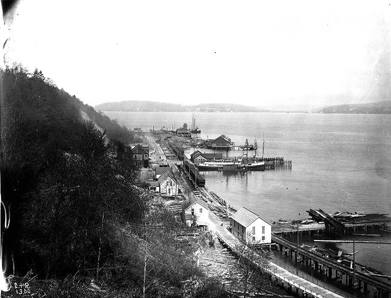
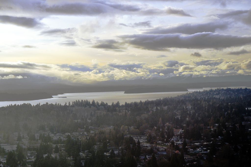
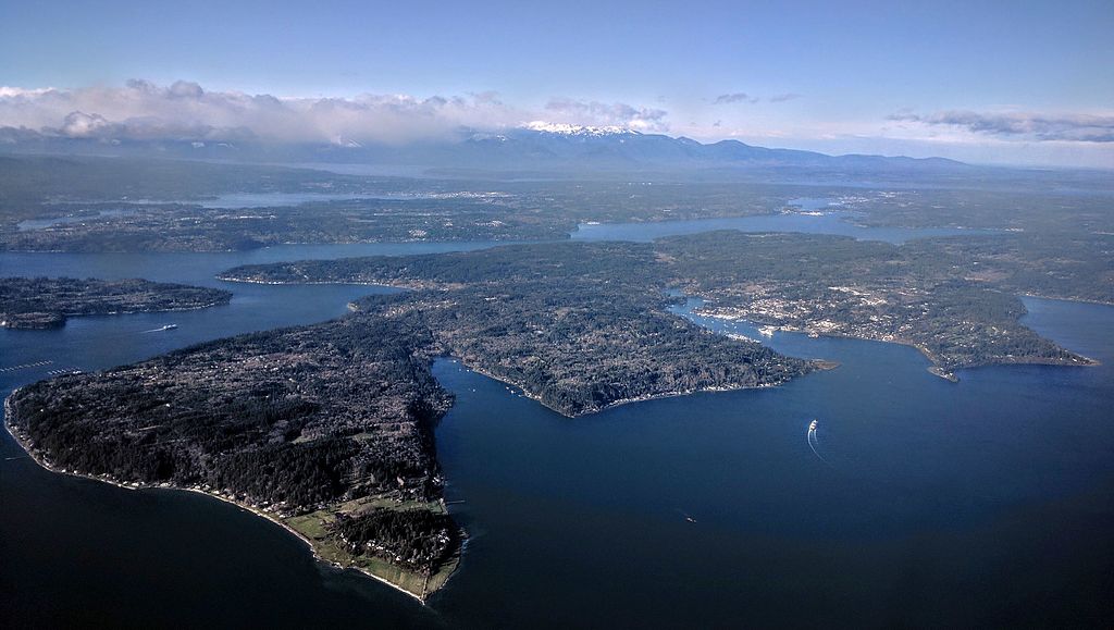
I enjoy writing posts on streets like W Commodore Way (I believe I am the first to have accurately identified its namesake), Division Avenue NW (I show that, even though it doesn’t divide anything from anything else today, it once served as Ballard’s eastern city limit for a few blocks), Loyal Avenue NW (I discover that it’s named not for the concept of loyalty, but for a baby girl whose first name was Loyal), and sluʔwiɫ (the University of Washington’s new Lushootseed-language name for Whitman Court). But sometimes I just like knocking something out quickly (I’m looking at you, W View Place and View Avenue NW). Sunset Avenue SW is another one of those. It originated in the 1888 First Plat of West Seattle by the West Seattle Land and Improvement Company, and the name simply refers to the street’s western view of Puget Sound; Vashon, Blake, and Bainbridge Islands; the Kitsap Peninsula; and the Olympic Mountains.

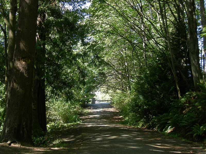
Sunset Avenue SW begins as a stairway at California Avenue SW, just across the street from Hamilton Viewpoint Park. Once the roadway begins up the hill, it goes ⅘ of a mile southwest to a dead end at the College Street Ravine southwest of 50th Avenue SW.

Schmitz Boulevard

This road, and the park through which it runs, Schmitz Park (or Schmitz Preserve Park), was named for German immmigrants Ferdinand Schmitz (1860–1942) and his wife, Emma Althoff Schmitz (1864–1959). Ferdinand was a banker, city councilman, and parks commissioner. He and Emma donated land — mostly, though not entirely, old-growth forest — to the city in 1908, forming the core (just over 55%) of the present park.

The Schmitzes had four children: Dietrich, Henry, Emma Henrietta, and Ferdinand Jr. A banker, Dietrich (1890–1969) became president of Washington Mutual in 1934 and retired as chairman of the board two years before his death. He was also a member of the Seattle School Board from 1928 (or 1930; sources differ) to 1961. Henry (1892–1965) was president of the University of Washington from 1952 to 1958. Schmitz Hall, the university’s administration building on NE Campus Parkway, was named in his memory in 1970.

https://commons.wikimedia.org/wiki/File:Seattle_-_Schmitz_Park_road_01.jpg
Schmitz Boulevard looking north toward SW Stevens Street and SW Admiral Way. September 2007. Photograph by Joe Mabel, Wikimedia Commons, licensed under Creative Commons Attribution-ShareAlike 3.0 Unported

According to the Friends of Seattle’s Olmsted Parks,

The roadway was originally envisioned as a continuation of the West Seattle Parkway, never realized, which would have connected Alki Beach to Lake Washington via a series of parkways. The built section is instead a short road that provided the only automobile entry to Schmitz Park, extending through an allée of trees and terminating at a pergola and shelterhouse.

Map of proposed West Seattle Parkway, cropped from a 1928 map of Seattle's park system
Map of proposed West Seattle Parkway, cropped from a 1928 map showing both existing (red) and proposed (red hatched) park features. Schmitz Park and Boulevard are at upper left. Courtesy of the Seattle Municipal Archives, Identifier 2333.

The portion between 59th Avenue SW and 58th Avenue SW in front of Alki Elementary School having been closed in 1949, Schmitz Boulevard today begins at 58th Avenue SW and SW Stevens Street and goes not quite half a mile east, then southeast, then north, to SW Admiral Way and SW Stevens Street. It is closed to automobile traffic.

Puget Boulevard SW

Puget Boulevard is a curious street, for a number of reasons:

  • The paved portions are only a few blocks long — hardly comparable to, say, Lake Washington Boulevard or Magnolia Boulevard;
  • Both east–west and north–south portions are called Puget Boulevard SW, contrary to the rule that directional designations precede street names for east–west streets (this is why Lake Washington Boulevard E becomes E Lake Washington Boulevard when it curves west on its approach to Montlake Boulevard E);
  • Despite its name, it has no view of Puget Sound, sitting as it does in the Longfellow Creek valley in the Delridge neighborhood of West Seattle;
  • And, as it turns out, it isn’t even named for Puget Sound, as might be expected, but rather for the Puget Mill Company (later part of Pope & Talbot and today part of Rayonier).

The Puget Mill Company, which once owned large swaths of land in the city (including what became the Washington Park Arboretum and the Broadmoor Golf Club), made two donations to the city in 1912, according to the Ninth Annual Report of the Board of Park Commissioners:

  • “A rugged tract of logged-off land south of Pigeon Point and Youngstown in the large unplatted area” (20.5 acres — this became Puget Park); and
  • “A strip of land 160 feet in width extending from Sixteenth Avenue Southwest and Edmonds Street (sic) to Thirty-fifth Avenue Southwest and Genessee Street, a distance of 8,500 feet, and comprising an area of about fifteen acres for parkway purposes. Under the conditions of this gift improvement work must be undertaken within five years. This acquisition forms an important link in the contemplated boulevard to West Seattle.”

This strip is today’s Puget Boulevard SW. Two things become apparent when looking at the King County Parcel Viewer map of West Seattle:

Map of Puget Boulevard, from King County Parcel Viewer

Once past the present site of West Seattle Stadium, the “contemplated boulevard to West Seattle” was to have run, as the Friends of Seattle’s Olmsted Parks puts it,

[Across] California Avenue a few blocks north of [the] present-day Alaska Junction, at that time part of the “Boston Subdivision.” It would have then headed northwest and down a ravine, eventually turning southwest to terminate at Alki Point.

Map of proposed West Seattle Parkway, cropped from a 1928 map of Seattle's park system
Map of proposed West Seattle Parkway, cropped from a 1928 map showing both existing (red) and proposed (red hatched) park features. Puget Park and Boulevard are at lower right. Courtesy of the Seattle Municipal Archives, Identifier 2333.

Returning to the question of the name — the Puget Mill Company was, of course, named after Puget Sound, which itself was named in 1792 by Captain George Vancouver of HMS Discovery for Lieutenant Peter Puget (1765–1822).

Today, the paved portion of Puget Boulevard SW begins at 23rd Avenue SW, about 1⁄10 of a mile north of SW Hudson Street, and goes ⅕ of a mile south to a dead end. After a very short section — not more than 150 feet long — east of Delridge Way SW, which serves as a driveway for a complex of townhouses, it resumes west of a foot path off Delridge and goes about 1⁄10 of a mile west to 26th Avenue SW. Along this stretch, there are houses to the north and the Delridge P-Patch and Puget Boulevard Commons to the south.

Point Place SW

This street, which was created in 1936, was named after Alki Point. Alki Avenue SW runs southwest from Duwamish Head to about 450 feet northeast of the point, where it turns south for a block and then becomes Beach Drive SW; Point Place continues another 200 or so feet toward Alki Point.

Alki Point Lighthouse, May 4, 2011. The first light here was supposedly hung in the 1870s; the U.S. Lighthouse Board installed an official one in 1887. The present lighthouse was built in 1913 and automated in 1984. Access is from Alki Avenue SW rather than Point Place SW. Public domain photograph by U.S. Coast Guard Chief Petty Officer Robert Lanier.
Arthur Armstrong Denny (1822–1899), the leader of the Denny Party that landed at Alki Point on November 13, 1851, helped build this cabin. Most of the party moved to what is now Pioneer Square the next spring. Photograph by Frank LaRoche, no date (though no later than 1891, when the cabin, shown here in ruins, was demolished).
Aerial view of West Seattle, March 17, 2009. Alki Point is in the lower-left-hand (west) corner; Duwamish Head is in the upper-left-hand (north) corner. The green spaces in the foreground, from left to right (north to south), are the Duwamish Head Greenbelt, Schmitz Preserve Park, and Mee-Kwa-Mooks Park. Elliott Bay lies north and east of Alki Point; the rest of the water is Puget Sound. Public domain photograph by Dcoetzee, Wikimedia Commons.

Alki Avenue SW

The settlement at Alki Point established by the Denny Party in 1851 was originally named New York. By a process that is not entirely clear, the name became New York–Alki, and then just Alki. Alki means ‘by and by’ or ‘someday’ in Chinook Jargon, the implication being that the settlement might rival New York… someday. Charles C. Terry officially applied the Alki name to the town plat he filed in 1853, and the point, street, and neighborhood were all named after it.

In the introduction to her 1937 book, Pig-Tail Days in Old Seattle, Sophie Frye Bass writes:

Please everyone, pronounce Alki as the Indians did, as if it were spelled “Alkey.”

Hardly anyone does this anymore — in fact I don’t think I’ve ever heard someone say /ælkiː/ in all seriousness when talking about West Seattle. /ælkaɪ/ is by far the preferred pronunciation, as shown by this informal Twitter poll I ran:

A screen shot of a Twitter poll by me, asking "Seattleites! I’m willing to bet you’ve always pronounced Alki as AL-kye (ælkaɪ), never as AL-kee (ælkiː). So this poll isn’t about how YOU pronounce it, but rather how you’ve heard OTHERS pronounce it." "I've only heard ALkye" gets 82.9%, "I've actually heard ALkee" 10%, "I SAY ALkee! Really" 2.9%, and Other (comment below) 4.3%

Note: On July 10, 2024, I began converting embedded tweets on this website to screenshots because of issues with how they were integrating with WordPress, which began not too long after Elon Musk purchased Twitter and changed its name to X.

Apparently the Denny descendants (Bass was the daughter of Louisa Catherine Denny, herself the daughter of Arthur Armstrong Denny and Louisa Catherine Boren) still prefer — nay, insist — on ALkee:

A screen shot of a tweet by Knute Berger saying "The Dennys insist on AL-kee"
A screen shot of a tweet by David B. Williams saying "I was once at a talk where a Denny family descendant chastised the audience for saying Alkye, instead of the correct Al-kee Oh well"
A screen shot of a tweet by Zach Works saying "I think I've only heard AL-kee from presenters (Brewster Denny?). I listened to this recording of a Squamish elder speaking Chinook Jargon and that seems to be closest to his pronunciation. See 12:55 mark:"
Louis Miranda: Suqmish Elder teaches Chinook Wawa on YouTube
Birthplace of Seattle monument, 1926. Courtesy of the Seattle Municipal Archives, Identifier 46980
Birthplace of Seattle monument, 1926. Originally dedicated in 1905 on the 54th anniversary of the landing of the Denny Party at Alki Point, it reads “At this place on 13 November 1851 there landed from the Schooner Exact Captain Folger [and] the little colony which developed into the City of Seattle.” It was rededicated, with a new foundation, on September 4, 1926 (likely the date of this photograph). A stone from near Plymouth Rock, Massachusetts, was put in the foundation, and the new plaque reads “From Plymouth Rock to Alki Point: Honoring pioneers on the American shores of the Atlantic and Pacific Oceans, the above stone was brought from Plymouth Rock by the First Transcontinental Motorized Caravan, managed by James H. Brown, and endorsed by the American Automobile Association. This tablet was furnished by the Automobile Club of Washington. The unveiling ceremonies on September 4, 1926, was participated in by officers and citizens of. the City of Seattle, the County of King and the State of Washington.” Courtesy of the Seattle Municipal Archives, Identifier 46980

As noted in Harbor Avenue SW and Beach Drive SW, the Alki Avenue name once stretched from Lincoln Park around Alki Point and Duwamish Head to the industrial area near Harbor Island, but sometime between 1912 and 1920 the name was reduced to the portion between Alki Point and Duwamish Head.

Today, Alki Avenue SW begins at Harbor Avenue SW by Duwamish Head and goes 2⅕ miles southwest to Beach Drive SW.

Beach Drive SW

Like Harbor Avenue SW, Beach Drive SW was once part of Alki Avenue SW. It became Beach Drive sometime between 1912 and 1920. In contrast to Alki and Harbor Avenues, most of Beach Drive’s beaches are private, though there is a long public stretch at the Emma Schmitz Memorial Outlook, as well as Lowman Beach Park at the south end.

Puget Sound shore looking northwest along Beach Drive with Alki Point in distance, August 2007
Puget Sound shore looking northwest along Beach Drive toward Alki Point, August 2007. Photograph by Joe Mabel, Wikimedia Commons, licensed under Creative Commons Attribution-ShareAlike 3.0 Unported

Beach Drive SW begins at Alki Avenue SW just south of Alki Point and goes just over 3 miles southeast to Trail #1 at Lincoln Park.

Signs at Beach Drive SW road end, March 2013
Signs along Beach Drive SW a little under 1,000 feet north of Lincoln Park. The park boundary sign is unofficial. Its placement appears to imply that the tail end of Beach Drive is private, which it’s not. Nor is the driveway (SW Othello Street) on the left. Photograph by Benjamin Lukoff, March 10, 2013. Copyright © 2013 Benjamin Lukoff. All rights reserved.

Harbor Avenue SW

As noted in Alaskan Way, Harbor Avenue SW was once part of Railroad Avenue. When the Elliott Bay tidelands were platted in 1895, Railroad Avenue stretched from (using current landmarks) the Magnolia Bridge along the waterfront to the Industrial District, then across Harbor Island to West Seattle, ending southwest of Duwamish Head. In 1907 the West Seattle portion was renamed Alki Avenue, and sometime between 1912 and 1920 it was given its current name.

Looking northwest up what is now Harbor Avenue SW toward Duwamish Head, April 1902

Today, Harbor Avenue SW begins at SW Avalon Way and SW Spokane Street at the west end of the West Seattle Bridge and goes 1¾ miles northwest to Duwamish Head, where it becomes Alki Avenue SW.

Street sign at corner of Harbor Avenue SW and Alki Avenue SW, October 2017
Street sign at corner of Harbor Avenue SW and Alki Avenue SW, Duwamish Head, with Elliott Bay and downtown Seattle in background, October 2017. Photograph by Ron Clausen, Wikimedia Commons, licensed under Creative Commons Attribution-ShareAlike 4.0 International

S Southern Street

Having covered E North Street, Eastern Avenue N, and Western Avenue, we now come to S Southern Street! This street originated in the 1891 plat of River Park, filed by Alexander Prentice (1820–1909) and his wife, Jane Thomson Prentice (1823–1911). It appears to be so named simply because it is the southernmost street in the plat, half a block north of the 1890 plat of South Park.

Portion of River Park addition showing Southern Avenue (now Southern Street)

S Southern Street begins just east of 12th Avenue S on the west bank of the Duwamish Waterway, and goes ½ a mile to just west of 7th Avenue S, where it is blocked by Washington State Route 99 (W Marginal Way S). (Its first tenth of a mile is within unincorporated King County as part of the “Sliver by the River.”) It begins again in West Seattle as SW Southern Street at 35th Avenue SW, and goes ⅗ of a mile to 44th Avenue SW.

Sign at corner of S Southern Street and Dallas Avenue S, May 20, 2013
Signs at corner of S Southern Street and Dallas Avenue S, May 20, 2013. Photograph by Benjamin Lukoff. Copyright © 2013 Benjamin Lukoff. All rights reserved.

S Graham Street

This street was named for Walter Graham (1828–1919), who came to Seattle in 1853. Three years later, he married Eliza Mercer, second daughter of Thomas Mercer (Mercer Street, Mercer Island), though she unfortunately died six years later. With his third wife, Elizabeth Crammond (or Crommon), he had a daughter, Nellie, who later married David Thomas Denny II, son of early settler David Thomas Denny (Denny Way). Graham’s brother, David, came to Seattle four years after his brother, and was one of the city’s first schoolteachers. He ended up marrying Eliza Mercer’s sister, Susannah.

Graham sold some of his southeast Seattle land in 1865 to Everett Smith, who filed the plat of Brighton Beach in 1890 on which what was then Graham Avenue appeared. He once owned what is today Seward Park on Bailey Peninsula, which was previously known as Graham’s Peninsula.

He was present at the Battle of Seattle in 1856, and is pictured below with fellow survivors Ira Woodin and Carson D. Boren (Boren Avenue).

Ira Woodin, Carson Boren, and Walter Graham, November 3, 1905
Ira Woodin, Carson Boren, and Walter Graham at Alki Point, November 3, 1905

S Graham Street begins in the east at Wilson Avenue S and goes 2⅒ miles west to Swift Avenue S and 20th Avenue S, just east of Interstate 5. After a short segment between Corgiat Drive S and 16th Avenue S just west of the freeway, it next appears in West Seattle. Betwen 16th Avenue SW and 22nd Avenue SW, it alternates between roadway, stairway, and pathway, and there is a similar situation between 25th Avenue SW at Delridge Way SW and High Point Drive SW at Bataan Park. SW Graham Street begins again at High Point Drive SW and SW Raymond Street and goes 1¼ miles to its end at 50th Avenue SW,

S Lander Street

I initially posted that this street was named for Judge Edward Lander (1816–1907), chief justice of the territorial supreme court from 1853 to 1857. In 1855, he, along with Charles Terry, bought Carson Boren’s downtown land claim for $500. They subsequently donated two acres of land, along with Arthur Denny, who donated eight, to form the first campus of the University of Washington, which opened in 1861. The university owns the Metropolitan Tract to this day, though it moved to its present location in 1895. Lander’s name also appears on Lander Hall, a UW dormitory on NE Campus Parkway.

Edward Lander
Edward Lander

However, I recently (April 2022) came across “What’s in a Name?,” a paper by Phillip H. Hoffman, director of the Alki History Project, in which he asserts that the correct namesake is Edward Lander’s brother, Frederick William Lander (1821–1862). I find his argument compelling. The street was named by Edward Hanford (S Hanford Street) when he filed the plat of Hanford’s Addition to South Seattle in 1869. Hanford also named streets for George McClellan and Isaac Stevens. All three men — McClellan, Stevens, and Frederick Lander — were part of the Northern Pacific Railroad Survey (1853–1855), and all three were likewise Union generals in the Civil War. Besides this,

Edward Lander was a political foe of and was jailed by Stevens [then governor of Washington Territory] when Lander opposed Stevens’ 1855 martial law declaration and actions. Stevens and Edward Lander maintained a widely recognized lifelong enmity. It is unlikely that Hanford would have memorialized this hostility.

Frederick William Lander
Frederick W. Lander

SW Lander Street begins at 59th Avenue SW in the Alki neighborhood of West Seattle, and goes ⅕ of a mile to 55th Avenue SW. It resumes just to the south at S Lander Place and goes a further ⅛ of a mile to SW Admiral Way. Picking up again at 50th Avenue SW, it makes it ½ a mile to Walnut Avenue SW before being interrupted again, as happens to so many West Seattle streets because of the varying topography. There is a final ¼-mile stretch in West Seattle from 39th Avenue SW to 36th Avenue SW, then a very short segment on Harbor Island before S Lander Street resumes in the Industrial District at Colorado Avenue S and goes ¾ of a mile east to Airport Way S. On Beacon Hill, Lander begins just west of 13th Avenue S and goes ⅔ of a mile to just past 23rd Avenue S, including the block-long stretch that is now known as S Roberto Maestas Festival Street. Lander begins again at 30th Avenue S in Mount Baker and goes a final four blocks to 34th Avenue S.

S Hanford Street

This street is named for Edward Hanford (1807–1884) and his wife, Abigail Jane Holgate (1824–1905), who left Iowa in the early 1850s to settle adjacent to Abigail’s brother, John (namesake of S Holgate Street), on what is today known as Beacon Hill but was known from then until the early 1890s as Holgate and Hanford Hill. Edward and his family were loggers, then orchardists, and unlike John Holgate, he went on to develop his donation claim.

The Hanfords’ son Clarence (1857–1920) founded, with James D. Lowman, the Lowman & Hanford Stationery and Printing Company in 1885. The firm went out of business in the 1960s, but their Pioneer Square building still, the last time I drove by, had a sign painted on it reading “Seattle’s Oldest Retail Company,” which it very well might have been when it closed. Their son Thaddeus (1847–1892) was for a time the owner of the Daily Intelligencer newspaper, predecessor of the Seattle Post-Intelligencer. And their son Cornelius (1849–1926), a federal judge from 1890 to 1912, was earlier a territorial legislator, Seattle city attorney, and chief justice of the Washington Supreme Court. He is the namesake of Hanford, Washington, and by extension the Hanford Site, which produced the plutonium used in the first nuclear explosion and the bombing of Nagasaki. He was also the author of Seattle and Environs, 1852-1924.

Edward Hanford
Edward Hanford

SW Hanford Street begins in West Seattle at SW Admiral Way and 59th Avenue SW and goes ¼ mile east to Schmitz Preserve Park at 56th Avenue SW. It begins again at 51st Avenue SW and goes nearly a mile east to 36th Avenue SW, becoming a stairway for the half-block east of 46th Avenue SW. After serving as little more than a driveway between SW Admiral Way and Fauntleroy Avenue SW, it next appears as S Hanford Street at E Marginal Way S, where it goes for ⅓ of a mile east to Occidental Avenue S. After a few short segments farther east in the Industrial District, Hanford begins again on Beacon Hill at 12th Avenue S and goes nearly a mile east to Rainier Avenue S, the segment between 25th Avenue S and Morse Avenue S being a stairway. It resumes a few blocks east at 30th Avenue S and finishes up ½ a mile east at Cascadia Avenue S.

S Holgate Street

This street is named for John Cornelius Holgate (1828–1868). Born in Ohio, he took the Oregon Trail west in 1847 and explored Elliott Bay and the Duwamish River by canoe in the summer of 1850. (The Seattle Times calls him “the first non-Indian of record to have done so.”) He returned to Oregon afterwards, however, and did not settle in what is now Seattle — specifically, Beacon Hill — until 1853, two years after the Denny Party landed at Alki Point. His mother, Elizabeth; brothers, Lemuel and Milton; and sister, Abigail, along with her husband, Edward Hanford (namesakes of S Hanford Street), soon followed. The Hanfords settled on the hill — known thereafter as Holgate and Hanford Hill until the late 1880s — adjacent to Holgate. (Milton was one of three whites to die in the Battle of Seattle in 1856, and was himself the cause of one of those deaths, having earlier shot Jack Drew, a deserting sailor from the USS Decatur, in a “friendly-fire” incident.)

A gold prospector, Holgate left for Idaho in 1863, and died there in 1868, the first casualty of the War Under the Mountain, a conflict between two rival gold mines in the Owyhee Desert, one of which he was part owner. According to Robert L. Deen, writing for True West magazine, there are conflicting accounts of Holgates death. The Owyhee Avalanche reported that:

Desperate fighting ensued during the charge…. John C. Holgate… one of the foremost in the advance, was shot in the head, and must have died instantaneously.

The Idaho Tri-Weekly Statesman had a slightly different story:

It appears that J.C. Holgate has been killed, some say assassinated, murdered — not killed in a fight, but shot through the head without provocation.

SW Holgate Street begins in West Seattle just west of 47th Avenue SW and goes ¼ of a mile east to California Avenue SW at Palm Avenue SW. There are two more short segments on the peninsula, between 41st Avenue SW and Arch Avenue SW and between Victoria Avenue SW and Brook Avenue SW. S Holgate Street resumes at Utah Avenue S and goes ¾ of a mile east to an overpass over Interstate 5, where it becomes Beacon Avenue S. There is a one-block stretch between 12th Avenue S and 13th Avenue S on top of the hill, and then Holgate goes a mile from the Beacon Hill Playfield at 14th Avenue S to 31st Avenue S at Colman Park, the half-block east of 16th Avenue S being a stairway and the block between 28th Avenue S and 29th Avenue S being unimproved. There is finally a short stretch east of Lakeside Avenue S at 36th Avenue S that essentially serves as a private driveway; it is a shoreline street end, but one not yet accessible to the public.

Lanham Place SW

Like SW Bataan Street, Lanham Place SW is part of High Point, originally developed by the Seattle Housing Authority in 1942 as defense housing and redeveloped in 2004. The name was originally applied to SW Lanham Way, and was preserved while some other names, including SW Snow Court, Cycle Lane SW, and MacArthur Court SW, were eliminated. It was named for Fritz G. Lanham, Texas congressman, who sponsored the Lanham Act that created the Defense Homes Corporation.

Today, Lanham Place SW begins at 32nd Avenue SW and SW Raymond Street and goes ¼ mile southeast to 31st Avenue SW, Sylvan Way SW, and SW Morgan Street.

SW Bataan Street

High Point, originally developed by the Seattle Housing Authority in 1942 as defense housing, was redeveloped in 2004. It was reconnected to the street grid, and as part of the process some street names, including SW Snow Court, Cycle Lane SW, MacArthur Court SW, and Bataan Place SW, were eliminated. (They are still visible in the city clerk’s geographic indexing atlas, which was created before the redevelopment and has not been updated.) No one appeared to care much about the loss of Snow, Cycle, or MacArthur (named for General Douglas MacArthur, who had recently evacuated to Australia when the fall of the Philippines seemed imminent).* The loss of Bataan, named for the World War II battle that took place on the Bataan Peninsula on the island of Luzon, was another story, however, and SW Eddy Street was quickly renamed SW Bataan Street, enabling the city to continue to “memorialize and honor the 10,000 American and Filipino soldiers who lost their lives in the Bataan death march.”

* See the August 7, 1943, Seattle Times article ‘City’s Wartime Additions Inspire Some Monickers’ for the story behind the street names in High Point, Rainier Vista, and other Seattle Housing Authority projects.

W Marginal Way SW

W Marginal Way SW, like its twin across the water, E Marginal Way S, began literally as a “marginal way” to “give railroads, street cars and other transportation facilities access to the Duwamish waterway.”

W Marginal Way SW begins at 26th Avenue SW at the Port of Seattle’s Terminal 5. From there, it’s 3 miles southeast to 2nd Avenue SW, by the south end of the 1st Avenue S Bridge. It resumes on the east side of the bridge as W Marginal Way S, an extension of Highland Park Way SW, and runs 4⅖ miles from there to the southern city limits. (For all but the first few blocks of this stretch, it is a limited-access highway carrying Washington State Route 99.) Beyond there it runs 3½ miles more to the vicinity of an interchange with Tukwila International Boulevard. The name is dropped at this point (and does not appear on signs south of the initial few blocks); the highway continues 1¾ miles as Washington State Route 599 to Interstate 5.

Duwamish Longhouse and Cultural Center, 4705 W Marginal Way SW, May 2010
Duwamish Longhouse and Cultural Center, 4705 W Marginal Way SW, May 2010. Photograph by Benjamin Lukoff, originally appearing in Seattle Then and Now.
Copyright © 2010 Benjamin Lukoff. All rights reserved.

W Marginal Way S is the location of the Duwamish Longhouse and Cultural Center, across the street from həʔapus Village Park and Shoreline Habitat (formerly Terminal 107 Park). həʔapus, or x̌əʔapus, was the name of a Duwamish village that was burned down by settlers in 1895. The new longhouse became the first one within city limits in 114 years. Notably, descendants of settlers Charles Terry and David Denny participated in fundraising and advocacy, without which the project would have been impossible, as the Duwamish were forced to purchase back the land. (A good article for more detail is “On the Duwamish River, a longhouse rises,” which appeared in Real Change in March 2009.)

S Front Street

Usually, a Front Street designates a city’s waterfront. Front Street in Philadelphia parallels the Delaware River; NW Front Avenue in Portland, Oregon, goes up the Willamette River; Front Street in Toronto runs along Lake Ontario. Seattle once had a prominent Front Street alongside Elliott Bay, but it was renamed 1st Avenue in 1895. The Front Street we do have runs a grand total of ⅖ of a mile split among three segments, and it runs east–west, while the nearby Duwamish River runs north–south. Why is this?

As it turns out, S Front Street — established as part of Joseph R. McLaughlin’s Water Front Addition to the City of Seattle in 1906 — did use to run along the river, before it was rechanneled beginning in 1913. (Here is an excellent post from the Burke Museum on the Duwamish meanders, with some great maps and aerials.) The maps below show its course along the Duwamish River Oxbow in 1912 (left) and its current landlocked state (right). You can still make out its former location, as well as small remnants in the form of the Slip 2 and Slip 3 inlets. (Incidentally, Front Street originally was shaped like a horseshoe — today’s S Front Street was originally North Front Street, and South Front Street is today S River Street.)

Portion of index page of Baist's Real Estate Atlas of Seattle, 1912, showing Duwamish River oxbowPortion of King County Parcel Viewer map and aerial view of Seattle showing former location of Duwamish River oxbow

Speaking of the Oxbow, here’s an advertisement for it. So much for that “16,000 feet of deep water frontage.”

Advertisement for Oxbow in June 1, 1906, issue of The Seattle Times

Today’s S Front Street begins at 6th Avenue S and goes ¼ of a mile west, ending just beyond 4th Avenue S. There is another 400-foot-long section between E Marginal Way S and 1st Avenue S, below the approach to the 1st Avenue S Bridge. And then there is one last 200-foot-long section on the west side of the Duwamish River — SW Front Street starts at W Marginal Way SW and ends at the entrance to the Port of Seattle’s Terminal 115 (which used to be Boeing Plant 1, the airplane manufacturer’s first production facility).

Incidentally, here’s a great article on the one in New Orleans I came across while looking up various Front Streets. It’s hard to beat a lede like this: “In a city replete with famed streets, scenic avenues and poetic street names, one particular artery excels at being obscure, nominally insipid, marvelously intermittent, and sometimes barely even a street.”

Sign at corner of SW Front Street and W Marginal Way SW, May 20, 2013
Sign at corner of SW Front Street and W Marginal Way SW, May 20, 2013. Photograph by Benjamin Lukoff. Copyright © 2013 Benjamin Lukoff. All rights reserved.

Vashon Place SW

This street — just about 350 feet long, like its neighbor Blake Place SW — connects SW Othello Street to Fauntleroy Way SW just north of Solstice Park. Created as part of the Lincoln Home Addition in 1907 by builder Albert Eugene Felmley and his wife, Mabel L. Felmley, it is named after Vashon Island, located 4 miles to the southwest, across Puget Sound. The island itself was named for Royal Navy Admiral James Vashon by his friend, Royal Navy Captain George Vancouver, in 1792.

Two other streets in the Lincoln Home Addition are named for Puget Sound islands: the already-mentioned Blake Place SW, and Bainbridge Place SW.

Aerial view of Vashon Island from the northwest
Aerial view of Vashon and Maury Islands from the northwest. Photograph by Flickr user Travis, licensed under Creative Commons Attribution-NonCommercial 2.0 Generic

Blake Place SW

This 350-foot-long street connects SW Othello Street to SW Fontanelle Street just north of Solstice Park. It was created as part of the Lincoln Home Addition in 1907 by builder Albert Eugene Felmley and his wife, Mabel L. Felmley, and is named after Blake Island, located 4⅖ miles to the west, across Puget Sound. The island itself was named for U.S. Navy Commodore George Smith Blake, then head of the United States Coast Survey, by Charles Wilkes in 1841.

Two other streets in the Lincoln Home Addition are named for Puget Sound islands: Bainbridge Place SW and Vashon Place SW.

Aerial view of Blake Island from the east
Aerial view of Blake Island from the east (West Seattle in foreground). Photograph by Joe Mabel, Wikimedia Commons, licensed under Creative Commons Attribution-Share Alike 3.0 Unported

Bainbridge Place SW

This short street — not quite 275 feet long — connects SW Othello Street to Fauntleroy Way SW just north of Lincoln and Solstice Parks. Created as part of the Lincoln Home Addition in 1907 by builder Albert Eugene Felmley and his wife, Mabel L. Felmley, it is named after Bainbridge Island, located 5¼ miles to the northwest, across Puget Sound. The island itself was named for U.S. Navy Commodore William Bainbridge, commander of the USS Constitution, by Charles Wilkes in 1841.

Two other streets in the Lincoln Home Addition are named for Puget Sound islands: Blake Place SW and Vashon Place SW.


Aerial view of Bainbridge Island from the southeast
Aerial view of Bainbridge Island from the southeast. Photograph by Dicklyon, Wikimedia Commons, licensed under Creative Commons Attribution-Share Alike 4.0 International

S Fontanelle Street

This fragmented street starts at Rainier Avenue S and travels two blocks west to 46th Avenue S. It makes its next appearance in Beacon Hill as a block-long street hanging off Military Road S, just east of Interstate 5. There are a few more blocks in South Park, from 5th to 2nd Avenues S, then half a block in West Seattle just west of California Avenue SW and a few final blocks from just east of Vashon Place SW to 47th Avenue SW at Lincoln Park. It is named for Fontanelle, Iowa, where Joseph and Catherine (Henderson) Dunlap (of S Henderson Street) lived before coming to Seattle in 1869.