St. Helens, of course, is best known for its volcanic eruption on May 18, 1980, “the deadliest and most economically destructive volcanic event in U.S. history” according to Wikipedia. It was variously known by the Native Americans as Lawetlat’la (Cowlitz) and Loowit or Louwala-Clough (Klickitat), and, like Mount Rainier and Mount Baker, was given its official English-language name by George Vancouver on HMS Discovery in 1792. In this case, it honored his friend Alleyne FitzHerbert, 1st Baron St Helens (1753–1839), who at the time was British ambassador to Spain.
Mount St. Helens Place S begins at Cascadia Avenue S and goes just over ¼ mile south to Mount Rainier Drive S at 37th Avenue S.
Born and raised in Seattle, Benjamin Donguk Lukoff had his interest in local history kindled at the age of six, when his father bought him settler granddaughter Sophie Frye Bass’s Pig-Tail Days in Old Seattle at the gift shop of the Museum of History and Industry. He studied English, Russian, and linguistics at the University of Washington, and went on to earn his master’s in English linguistics from University College London. His book of rephotography, Seattle Then and Now, was published in 2010. An updated version came out in 2015.
This street was created in 1907 as part of the Mt. Baker Park addition, named for its view of Mount Baker in the North Cascades. In addition to S Mount Baker Boulevard, the neighborhood featured a number of other streets named for mountains in the Cascade Range, including this one, named after Mount Rainier.
According to Wikipedia, at 14,411 feet, Mount Rainier is “the highest mountain in… Washington and the Cascade Range, the most topographically prominent mountain in the contiguous United States, and the tallest in the Cascade Volcanic Arc.” It has been known by a number of other names, including Tacoma (after which, incidentally, Takoma Park, Maryland, was named), which derived from its Lushootseed-language name, təqʷubəʔ (‘permanently snow-covered mountain’). It was given its official English-language name by George Vancouver on HMS Discovery in 1792:
The weather was serene and pleasant, and the country continued to exhibit between us and the eastern snowy range the same luxuriant appearance. At is northern extremity, Mount Baker bore by compass N. 22 E.; the round snowy mountain, now forming its southern extremity, and which, after my friend, Rear Admiral [Peter] Rainier [1741–1808], I distinguish by the name of Mount Rainier, bore N. 42 E.
Mount Rainier Drive S begins at the intersection of S McClellan Street, Lake Park Drive S, and Mount Baker Drive S, and goes ¼ mile southeast to S Hanford Street and Hunter Boulevard S.
Born and raised in Seattle, Benjamin Donguk Lukoff had his interest in local history kindled at the age of six, when his father bought him settler granddaughter Sophie Frye Bass’s Pig-Tail Days in Old Seattle at the gift shop of the Museum of History and Industry. He studied English, Russian, and linguistics at the University of Washington, and went on to earn his master’s in English linguistics from University College London. His book of rephotography, Seattle Then and Now, was published in 2010. An updated version came out in 2015.
Like its neighbors S Hudson Street and S Americus Street, S Ferdinand Street was created in 1891 as part of the plat of Columbia. (The town incorporated in 1893 and was annexed to Seattle in 1907, becoming the neighborhood of Columbia City.) Along with Columbus Street, which no longer exists, they were part a of series of streets named after explorers — in this case, Ferdinand Magellan (born Fernão de Magalhães, also known as Fernando de Magallanes) (1480–1521), the first explorer to sail from Europe to Asia via the Atlantic and Pacific Oceans.
S Ferdinand Street begins at Lake Washington Boulevard S and goes a block west to just past 55th Avenue S. It is a stairway between 54th Avenue S and 53rd Avenue S, then begins again at 52nd Avenue S. After a half block as roadway and another half block as stairway, it begins in earnest at 51st Avenue S by Lakewood Park and goes just over a mile west to 31st Avenue S. It is another stairway for the next block, and then a stub off 30th Avenue S.
On Beacon Hill, S Ferdinand Street begins again at 28th Avenue S and goes ½ a mile west to 20th Avenue S, then resumes at 19th Avenue S and goes a further ⅖ to 13th Avenue S. It finishes up as a short connector from 12th Avenue S to Corson Avenue S by Maple Wood Playfield.
Born and raised in Seattle, Benjamin Donguk Lukoff had his interest in local history kindled at the age of six, when his father bought him settler granddaughter Sophie Frye Bass’s Pig-Tail Days in Old Seattle at the gift shop of the Museum of History and Industry. He studied English, Russian, and linguistics at the University of Washington, and went on to earn his master’s in English linguistics from University College London. His book of rephotography, Seattle Then and Now, was published in 2010. An updated version came out in 2015.
This street was created in 1891 as part of the plat of Columbia, which incorporated in 1893 and was annexed to Seattle in 1907, becoming the neighborhood of Columbia City. Part of a series of streets named after explorers — (Christopher) Columbus Street (subsequently changed to Edmunds Street), Ferdinand (Magellan) Street, and Americus (Vespucci) Street — it was named for English explorer Henry Hudson (c. 1565–disappeared 1611), namesake of Hudson Bay in Canada and the Hudson River in New York and New Jersey.
After a false start as a dead-end road west of 57th Avenue S, S Hudson Street begins at 53rd Avenue S and goes ⅓ of a mile west to 47th Avenue S, becoming a stairway between 50th Avenue S and 49th Avenue S. It resumes at 46th Avenue S and goes ¾ of a mile west to Martin Luther King Jr. Way S. After another couple of short segments, it begins again at 28th Avenue S and goes ¼ mile west to 24th Avenue S. There are two more short segments on Beacon Hill, and then Hudson Street resumes in Georgetown, going ⅖ of a mile from 4th Avenue S to E Marginal Way S.
In West Seattle, SW Hudson Street begins as a service road and footpath within Puget Park off 18th Avenue SW. Its first appearance as a residential street is at Puget Boulevard SW, where it goes ⅕ of a mile to the West Seattle Golf Course. It then picks up again at 35th Avenue SW, where it goes just over a mile to SW Jacobsen Road, becoming a stairway three separate times along the way.
Born and raised in Seattle, Benjamin Donguk Lukoff had his interest in local history kindled at the age of six, when his father bought him settler granddaughter Sophie Frye Bass’s Pig-Tail Days in Old Seattle at the gift shop of the Museum of History and Industry. He studied English, Russian, and linguistics at the University of Washington, and went on to earn his master’s in English linguistics from University College London. His book of rephotography, Seattle Then and Now, was published in 2010. An updated version came out in 2015.
This street was created in 1891 as part of the plat of Columbia, which incorporated in 1893 and was annexed to Seattle in 1907, becoming the neighborhood of Columbia City. It was part of a series of streets named after explorers. Columbus Street, named for Christopher Columbus, is no more, but Ferdinand Street (Ferdinand Magellan), Hudson Street (Henry Hudson), and Americus Street (named for Amerigo Vespucci [1451–1512]) still exist. (Vespucci, of course, is the namesake of the Americas).
S Americus Street exists in two short segments: the Columbia City one begins at 42nd Avenue S and goes a block west to 39th Avenue S, and the Beacon Hill one begins at 26th Avenue S and goes a block west to S Columbian Way.
Born and raised in Seattle, Benjamin Donguk Lukoff had his interest in local history kindled at the age of six, when his father bought him settler granddaughter Sophie Frye Bass’s Pig-Tail Days in Old Seattle at the gift shop of the Museum of History and Industry. He studied English, Russian, and linguistics at the University of Washington, and went on to earn his master’s in English linguistics from University College London. His book of rephotography, Seattle Then and Now, was published in 2010. An updated version came out in 2015.
This street was named for Lincoln Park, which occupies Williams Point in West Seattle. Originally called Williams Point Park in the Olmsted Brothers’ 1908 report to the city, the 135-acre park was intended to be named Fauntleroy Park. However, when it opened in 1922, it was decided to name it after President Abraham Lincoln (1809–1865) instead, according to Seattle parks historian Don Sherwood. This required that Lincoln Beach, just to the north, be renamed Lowman Beach, and that Lincoln Park Playfield on Capitol Hill (named for the adjacent Lincoln Reservoir) be renamed Broadway Playfield. (Today, the entire tract is known as Cal Anderson Park, which contains the reservoir and the once-again-renamed Bobby Morris Playfield. A Fauntleroy Park was finally established in the early 1970s.)
Lincoln Park Way SW begins at Beach Drive SW and 48th Avenue SW and goes ¼ of a mile southeast to 47th Avenue SW between SW Myrtle Street and SW Othello Street. The park begins 500 feet to the south, at the corner of 47th Avenue SW and SW Fontanelle Street.
Born and raised in Seattle, Benjamin Donguk Lukoff had his interest in local history kindled at the age of six, when his father bought him settler granddaughter Sophie Frye Bass’s Pig-Tail Days in Old Seattle at the gift shop of the Museum of History and Industry. He studied English, Russian, and linguistics at the University of Washington, and went on to earn his master’s in English linguistics from University College London. His book of rephotography, Seattle Then and Now, was published in 2010. An updated version came out in 2015.
This West Seattle street was created in 1919 as part of the plat of Kirkwood, an Addition to the City of Seattle, filed by Isabell A. Kirkwood (1833–1926), who named the nearby Rutan Place SW after her maiden name. The plat document was notarized by lawyer Frank Pardee Lewis (1851–1938), and since I can find no connection to any other Lewis, I assume Kirkwood named it after him. According to Capitol Hill Seattle, Lewis, who lived at the corner of 18th Avenue E and E Denny Way,
…was from Triangle, New York, and moved to Seattle in 1887. He was a prominent attorney with offices in the Lowman Building downtown starting in 1890. He went to the office almost every day until his death in 1938. Mr. Lewis was elected to the Washington State Legislature in 1895; he was also a member of the Scottish Rite Masons.
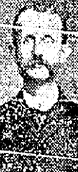
Lewis Place SW begins at SW Hudson Street between Erskine Way SW and California Avenue SW and goes just over 550 feet northwest, then north, to Erskine Way SW just west of California.
Frank Pardee Lewis, from his Seattle Times obituary, April 12, 1938
Born and raised in Seattle, Benjamin Donguk Lukoff had his interest in local history kindled at the age of six, when his father bought him settler granddaughter Sophie Frye Bass’s Pig-Tail Days in Old Seattle at the gift shop of the Museum of History and Industry. He studied English, Russian, and linguistics at the University of Washington, and went on to earn his master’s in English linguistics from University College London. His book of rephotography, Seattle Then and Now, was published in 2010. An updated version came out in 2015.
Rutan Place SW goes around 350 feet south from SW Edmunds Street between 44th Avenue SW and 45th Avenue SW to a dead end just short of 45th, though the undeveloped right-of-way does continue to that street.
Born and raised in Seattle, Benjamin Donguk Lukoff had his interest in local history kindled at the age of six, when his father bought him settler granddaughter Sophie Frye Bass’s Pig-Tail Days in Old Seattle at the gift shop of the Museum of History and Industry. He studied English, Russian, and linguistics at the University of Washington, and went on to earn his master’s in English linguistics from University College London. His book of rephotography, Seattle Then and Now, was published in 2010. An updated version came out in 2015.
This West Seattle street was created in 1907 as part of the plat of Adams 1st Addition to Fauntleroy Park, filed by John F. Adams (1860–1954) and his wife, Maggie W. True Adams (1864–1941). The document was notarized by Bert Avery Northrop (1880–1963), who was the husband of the Adamses’ daughter Abbie T. Adams (1888–1984). In his Seattle Times obituary, we learn that John Adams was “one of Fauntleroy’s first residents, [who]… came here in 1897. He first was in the grocery business and entered the real-estate business in 1903.… Mr. Adams was known as the ‘mayor of Fauntleroy.’” Meanwhile, Northrop’s Times obituary reports he came to Seattle in 1902 and began practicing law in 1906; he married Abbie Adams in 1909.
Bert A. Northrop
Northrop Place SW begins at SW Thistle Street and goes a block north to SW Southern Street.
Born and raised in Seattle, Benjamin Donguk Lukoff had his interest in local history kindled at the age of six, when his father bought him settler granddaughter Sophie Frye Bass’s Pig-Tail Days in Old Seattle at the gift shop of the Museum of History and Industry. He studied English, Russian, and linguistics at the University of Washington, and went on to earn his master’s in English linguistics from University College London. His book of rephotography, Seattle Then and Now, was published in 2010. An updated version came out in 2015.
This street is named for William Ashworth (1840–1906). According to the Haller Lake Community Club, Ashworth was born in England, emigrated to the United States in 1861, and came to Seattle in 1872.
Ashworth platted a town called Edgewater on the northern shore of Lake Union.… This area is now roughly the eastern part of Fremont and western portion of Wallingford.… Ashworth served as Edgewater’s only postmaster from 1889 until the area was annexed to Seattle two years later. As real estate development moved northward, so did the street bearing Ashworth’s name. Ashworth continued to live in Edgewater until his death in 1906.
Here is an article by local historian Paul Dorpat on Edgewater, on which it looks like I commented 13 years ago. And we learn both from the HLCC and Valarie Bunn of Wedgwood in Seattle History that the land on which berry farmer Ashworth’s home once stood is now the North Transfer Station (i.e., the city dump).
Today, Ashworth Avenue N begins at N 35th Street and goes ⅔ of a mile north to N 43rd Street. It resumes at N 55th Street and goes ¼ mile north to E Green Lake Way N, then begins again on the north side of the lake at Winona Avenue N and W Green Lake Drive N. From here, it goes another ⅔ of a mile to N 90th Street. Picking up again at N 92nd Street, it goes a further ⅞ of a mile to the Evergreen Washelli Cemetery at N 110th Street. It resumes one more time at N 120th Street and Stendall Drive N and goes 1¼ miles north to the city limits at N 145th Street, becoming a footpath for two short stretches west of Haller Lake. (As with many other North Seattle avenues, the name continues on into Shoreline; Ashworth Avenue N continues north of the city limits as far as N 200th Street, just south of the King–Snohomish county line at N 205th Street.)
Born and raised in Seattle, Benjamin Donguk Lukoff had his interest in local history kindled at the age of six, when his father bought him settler granddaughter Sophie Frye Bass’s Pig-Tail Days in Old Seattle at the gift shop of the Museum of History and Industry. He studied English, Russian, and linguistics at the University of Washington, and went on to earn his master’s in English linguistics from University College London. His book of rephotography, Seattle Then and Now, was published in 2010. An updated version came out in 2015.
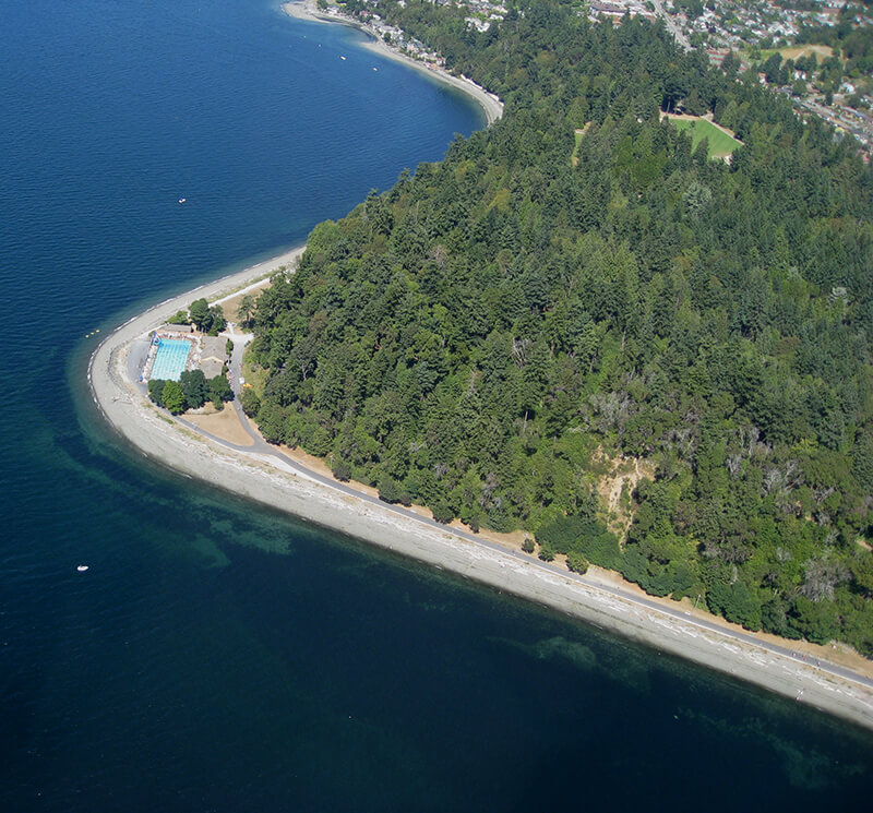
This road is named after Seward Park, which occupies all of Bailey Peninsula’s 300 acres, as envisioned by the Olmsted Brothers. The park itself was bought by the city in 1911 and named after William Henry Seward (1801–1872), who was governor of New York from 1839–1842, senator from New York from 1849–1861, and secretary of state under Abraham Lincoln and Andrew Johnson from 1861–1869. His negotiation of the purchase of Alaska from Russia in 1867 proved to be a major boon for Seattle, which nearly doubled its population between 1890 and 1900 due in no small part to the Klondike Gold Rush, and remains a gateway to Alaska to this day.
Seward Park Road begins at Lake Washington Boulevard S and S Juneau Street and winds for ⅓ of a mile into the park’s interior, where it becomes a ¾-mile-long loop. (It should not be confused with Shore Loop Road, which runs along the park’s perimeter on the Lake Washington shoreline and is not open to vehicle traffic. Like all park roads in Seattle, Seward Park Road carries no directional designation)
Article in The Seattle Times on the naming of Seward Park, June 11, 1911. William Elder Bailey paid $26,000 to buy Bailey Peninsula in 1889 and the city began to consider it a potential park shortly thereafter. (It had previously been known as Graham Peninsula, after early settler David Graham, and Andrews Peninsula [though no one is sure who this Andrews might have been].) Bailey made it difficult for the city, finally offering to sell it for $430,000 in 1908, but the city ended up acquiring it for a more reasonable $322,000 in early 1911. Read more at HistoryLink.org and Friends of Seward Park.
Aerial view of Seward Park from the south, circa 1965–1966. The Martha Washington School for Girls, (closed 1971, now Martha Washington Park) is in the foreground. Mercer Island and Lake Washington are in the background. Courtesy of the Seattle Municipal Archives, Identifier 192974.
Born and raised in Seattle, Benjamin Donguk Lukoff had his interest in local history kindled at the age of six, when his father bought him settler granddaughter Sophie Frye Bass’s Pig-Tail Days in Old Seattle at the gift shop of the Museum of History and Industry. He studied English, Russian, and linguistics at the University of Washington, and went on to earn his master’s in English linguistics from University College London. His book of rephotography, Seattle Then and Now, was published in 2010. An updated version came out in 2015.
Born and raised in Seattle, Benjamin Donguk Lukoff had his interest in local history kindled at the age of six, when his father bought him settler granddaughter Sophie Frye Bass’s Pig-Tail Days in Old Seattle at the gift shop of the Museum of History and Industry. He studied English, Russian, and linguistics at the University of Washington, and went on to earn his master’s in English linguistics from University College London. His book of rephotography, Seattle Then and Now, was published in 2010. An updated version came out in 2015.
Wetmore “founded Seattle’s first tannery and shoe making business in 1855” with Milton Daniel Woodin (1800–1869), who was the father of his wife, Ann Woodin Wetmore (1829–1886). (Woodinville, located northeast of Seattle along the Sammamish River, was named after the Woodin family.) He homesteaded land in Rainier Valley, which later became the subject of a lawsuit against him by all his children except Jane. As the Seattle Post-Intelligencer reported on September 17, 1892,
Seymour Wetmore is an old settler in this section, who took up a government claim of 160 acres of land, which lies across the present line of the Rainier avenue electric railway. With the growth of Seattle Wetmore, by the increase of the values of property, found himself quite a wealthy man.… After the death of his wife her share was divided among the seven children, each of whom received $5,500. The amount that the father has kept for himself is now valued at about $25,000.… Last July a petition was filed… asking for the appointment of a guardian for Seymour Wetmore, on the ground that he was an habitual drunkard and incapable of taking care of himself.… The eldest son… swore to the petition, which set out that the father was addicted to dangerous excess in the use of intoxicating liquors, and was in the habit of going around in the company of lewd women and squandering his money.… [Wetmore] admitted that he drank. He had always been a drinking man and always would be. But he indignantly denied the charges that he associated with lewd women. By his answers he intimated that the… proceedings were due to a desire on the part of the children to tie up his property so that they would be sure of it in case of his death.
Finally, in February 1895, the matter was settled, as the Post-Intelligencer reported on the 28th under the headline ‘Seymour Wetmore Will Be Free to Squander His Wealth — He only yearns to spend it’. The article first recapped the origin of the lawsuit:
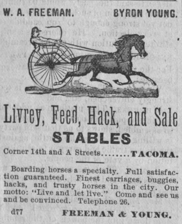
He felt as rich as any of the lords of creation, and worked himself up to the intoxication of enjoyment by spending money for the sole pleasure of seeing it go. He went about, his pockets lined with $20 pieces. This sort of thing grew tiresome to his prospective heirs, who became desperate on learning that Wetmore had entered into a deal with Byron Young, of Tacoma, whereby the latter received, in return for a bauble, $8,000 in money and 50 lots in Byron addition.
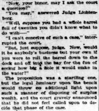
Excerpt from Seattle Post-Intelligencer article, from February 28, 1895, issue on Seymour Wetmore’s guardianship case, in which Wetmore argues for his right to do whatever he wants with his money, including destroying it
The case dragged on for a while, but, as it turns out,
Pending the decision of the supreme court the property involved had been transferred and retransferred again and again until an abstract of title would make a formidable document. In consequence the case of [Wetmore’s guardian] vs. Young was dismissed by stipulation in the equity department last Saturday. There is now nothing left to fight over, and the inevitable conclusion is that the aged ward will be found able to take care of himself.
Wetmore Avenue S begins at 30th Avenue S just south of S Hanford Street, crosses S Byron Street, and goes 800 feet southeast to S Walden Street. There is another short segment — around 150 feet long — south of S Estelle Street, which turns into a footpath of about equal length connecting to S Spokane Street.
Born and raised in Seattle, Benjamin Donguk Lukoff had his interest in local history kindled at the age of six, when his father bought him settler granddaughter Sophie Frye Bass’s Pig-Tail Days in Old Seattle at the gift shop of the Museum of History and Industry. He studied English, Russian, and linguistics at the University of Washington, and went on to earn his master’s in English linguistics from University College London. His book of rephotography, Seattle Then and Now, was published in 2010. An updated version came out in 2015.
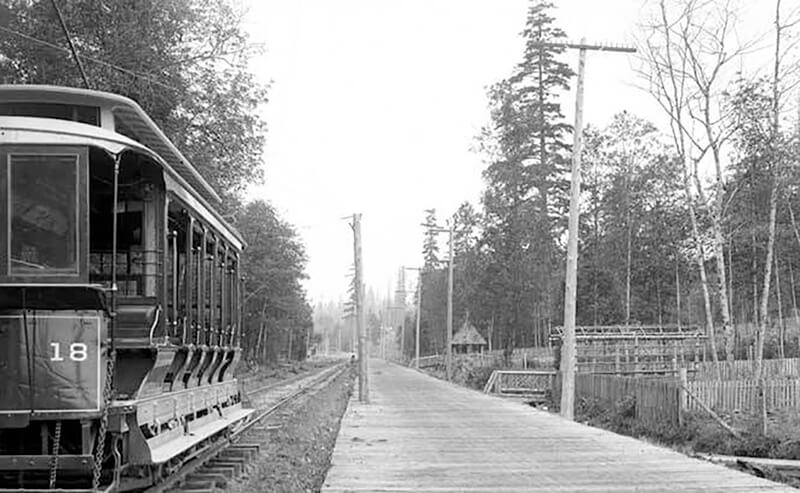
This street follows the route of the Rainier Avenue Electric Railway Company’s Seattle-to-Renton line, which began to be built in 1891. Both the rail line and street were named for Mount Rainier (təqʷubəʔ), itself named by Captain George Vancouver for his friend, Royal Navy Rear Admiral Peter Rainier (1741–1808). As the Seattle Post-Intelligencer noted on September 3, 1890, “the avenue points straight toward Mount Rainier, which mountain will be in plain view all the way.”
Rainier Avenue S begins at the intersection of S Jackson Street, Boren Avenue S, and 14th Avenue S, and goes nearly 8 miles southeast to the city limits. From there, it continues around 3¾ miles south to the intersection of Interstate 405 and State Route 167 in Renton.
Aerial view of Rainier Valley, Beacon Hill, and Downtown, May 22, 2001. Rainier Avenue S is the tree-lined street running up the middle of the photograph. Courtesy of the Seattle Municipal Archives, Identifier 114373.
Born and raised in Seattle, Benjamin Donguk Lukoff had his interest in local history kindled at the age of six, when his father bought him settler granddaughter Sophie Frye Bass’s Pig-Tail Days in Old Seattle at the gift shop of the Museum of History and Industry. He studied English, Russian, and linguistics at the University of Washington, and went on to earn his master’s in English linguistics from University College London. His book of rephotography, Seattle Then and Now, was published in 2010. An updated version came out in 2015.
This street was named for Carkeek Park, which encompasses 216 acres in the Broadview neighborhood, including Pipers Creek and nearly ½ a mile of Puget Sound waterfront (though the usable beach is much shorter, as the main line of the BNSF Railway cuts off public access to the rest). It was one of the “46 new street names to simplify street addresses” The Seattle Times reported on in its issue November 6, 1960, and was made up of “Sixth Avenue Northwest from West 110th to West 111th Streets, West 111th Street from Sixth to Seventh Avenues Northwest, Seventh Avenue NW from West 111th to West 114th Streets, and West 114th Street from Seventh Avenue NW to West 116th Street.” (Part of this route was once Puget Drive, part of the 1911 View-Lands Addition.)
Morgan Carkeek, 1910Emily Carkeek, 1911
The park itself opened in 1929 and was named for Morgan James Carkeek (1847–1931) and his wife, Emily Gaskill Carkeek (1852–1926). According to the Museum of History & Industry, “Morgan… was an accomplished stonemason and successful building contractor who built several of Seattle’s early stone buildings, such as the Dexter Horton Bank, and large office buildings, including the Burke and Haller buildings.” In 1918, he and Emily donated land to the city for the first Carkeek Park, located along Lake Washington where Magnuson Park is today, but soon thereafter plans were made to develop Naval Air Station Seattle on the land, and the park was taken over by the Navy in 1926. The Carkeeks donated $25,000 to the city to purchase land elsewhere, and with the addition of $100,000 in public funds the city was able to buy Piper’s Canyon.
Report in The Seattle Times, May 28, 1927, on the Carkeeks’ contribution of funds to buy Piper’s Canyon. The Seattle Historical Society, which they had a hand in founding, never did build a museum in Carkeek Park, but ended up building the Museum of History & Industry in Montlake’s McCurdy Park instead. MOHAI opened in 1952 and moved to Lake Union Park in 2012 after having to make way for the expansion of Washington State Route 520.
NW Carkeek Park Road begins at NW 110th Street and Puget Drive NW and winds ½ a mile northwest to the entrance to Carkeek Park at NW 114th Street. Within the park, it goes a further ½ mile west, ending at a parking lot, picnic area, and playground. (This portion appears to have once been known as Piper’s Canyon Road or Pipers Road.) From here, there is a bridge over the BNSF Railway tracks to a beach along Puget Sound and the mouth of Pipers Creek.
Aerial view of Carkeek Park, looking southeast, July 9, 1969. The valley and outlet of Pipers Creek are clearly visible, as is the main line of the BNSF Railway that separates the park’s wooded and grassy areas from Puget Sound. Courtesy of the Seattle Municipal Archives, Identifier 77628.
Born and raised in Seattle, Benjamin Donguk Lukoff had his interest in local history kindled at the age of six, when his father bought him settler granddaughter Sophie Frye Bass’s Pig-Tail Days in Old Seattle at the gift shop of the Museum of History and Industry. He studied English, Russian, and linguistics at the University of Washington, and went on to earn his master’s in English linguistics from University College London. His book of rephotography, Seattle Then and Now, was published in 2010. An updated version came out in 2015.
S Kenny Street begins on Beacon Hill at 21st Avenue S and goes two blocks east to 23rd Avenue S. It resumes in Hillman City at 42nd Avenue S and goes ¼ mile east to a dead end east of Rainier Avenue S. Its final segment, just under 400 feet long, lies west of 51st Avenue S and dead-ends at some private driveways.
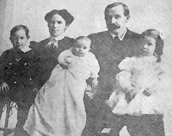
Bessie and C.D. Hillman and family, from a 1910 abstract of title for C.D. Hillman’s Birmingham Water Front Addition to the City of Everett
Born and raised in Seattle, Benjamin Donguk Lukoff had his interest in local history kindled at the age of six, when his father bought him settler granddaughter Sophie Frye Bass’s Pig-Tail Days in Old Seattle at the gift shop of the Museum of History and Industry. He studied English, Russian, and linguistics at the University of Washington, and went on to earn his master’s in English linguistics from University College London. His book of rephotography, Seattle Then and Now, was published in 2010. An updated version came out in 2015.
Born and raised in Seattle, Benjamin Donguk Lukoff had his interest in local history kindled at the age of six, when his father bought him settler granddaughter Sophie Frye Bass’s Pig-Tail Days in Old Seattle at the gift shop of the Museum of History and Industry. He studied English, Russian, and linguistics at the University of Washington, and went on to earn his master’s in English linguistics from University College London. His book of rephotography, Seattle Then and Now, was published in 2010. An updated version came out in 2015.
Born and raised in Seattle, Benjamin Donguk Lukoff had his interest in local history kindled at the age of six, when his father bought him settler granddaughter Sophie Frye Bass’s Pig-Tail Days in Old Seattle at the gift shop of the Museum of History and Industry. He studied English, Russian, and linguistics at the University of Washington, and went on to earn his master’s in English linguistics from University College London. His book of rephotography, Seattle Then and Now, was published in 2010. An updated version came out in 2015.
Born and raised in Seattle, Benjamin Donguk Lukoff had his interest in local history kindled at the age of six, when his father bought him settler granddaughter Sophie Frye Bass’s Pig-Tail Days in Old Seattle at the gift shop of the Museum of History and Industry. He studied English, Russian, and linguistics at the University of Washington, and went on to earn his master’s in English linguistics from University College London. His book of rephotography, Seattle Then and Now, was published in 2010. An updated version came out in 2015.
This street was created as part of the 1889 plat of West Seattle Park and named after West Seattle developer and Seattle city councilman Uriah Roush Niesz (1849–1929). According to Images of America: West Seattle,
…In what is now the Admiral District, the now familiar moniker “West Seattle” was first used by Uriah Niesz when developing five-acre homesites in 1885.
[He took] a prominent part in the replatting and upbuilding of the city. He with other members of the council had mapped out the whole plan some time previous to the fire, which made it possible to accomplish their purpose.… As a member of the council Mr. Niesz was made chairman of the judiciary, finance and harbor and wharves committees and the last named took up the whole burden of replatting the business and shipping section of the city.… Herculean as was the task of this committee in bringing order out of chaos in this part of the city; in opening the way for land and water traffic to meet at a minimum cost of transshipment; in providing facilities for a marvelous growth in the business of a future great city; in short in giving the city a new birth, yet this great task paled into insignificance compared with the responsibilities resting upon the finance committee, of which Mr. Niesz was also chairman.
I find that contemporary biographies of pioneers tend to read like hagiographies, but in this case I think Niesz’s entire biography is worth a read.
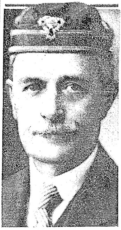
At left, Niesz as part of a portrait of Seattle’s mayor and city councilmen for 1888–1890. At right, the photograph accompanying his obituary in the Seattle Post-Intelligencer issue of September 22, 1929.
SW Niesz Court begins at 50th Avenue SW just south of the College Street Ravine and goes two blocks east to 48th Avenue SW.
Born and raised in Seattle, Benjamin Donguk Lukoff had his interest in local history kindled at the age of six, when his father bought him settler granddaughter Sophie Frye Bass’s Pig-Tail Days in Old Seattle at the gift shop of the Museum of History and Industry. He studied English, Russian, and linguistics at the University of Washington, and went on to earn his master’s in English linguistics from University College London. His book of rephotography, Seattle Then and Now, was published in 2010. An updated version came out in 2015.


