Born and raised in Seattle, Benjamin Donguk Lukoff had his interest in local history kindled at the age of six, when his father bought him settler granddaughter Sophie Frye Bass’s Pig-Tail Days in Old Seattle at the gift shop of the Museum of History and Industry. He studied English, Russian, and linguistics at the University of Washington, and went on to earn his master’s in English linguistics from University College London. His book of rephotography, Seattle Then and Now, was published in 2010. An updated version came out in 2015.
Born and raised in Seattle, Benjamin Donguk Lukoff had his interest in local history kindled at the age of six, when his father bought him settler granddaughter Sophie Frye Bass’s Pig-Tail Days in Old Seattle at the gift shop of the Museum of History and Industry. He studied English, Russian, and linguistics at the University of Washington, and went on to earn his master’s in English linguistics from University College London. His book of rephotography, Seattle Then and Now, was published in 2010. An updated version came out in 2015.
Born and raised in Seattle, Benjamin Donguk Lukoff had his interest in local history kindled at the age of six, when his father bought him settler granddaughter Sophie Frye Bass’s Pig-Tail Days in Old Seattle at the gift shop of the Museum of History and Industry. He studied English, Russian, and linguistics at the University of Washington, and went on to earn his master’s in English linguistics from University College London. His book of rephotography, Seattle Then and Now, was published in 2010. An updated version came out in 2015.
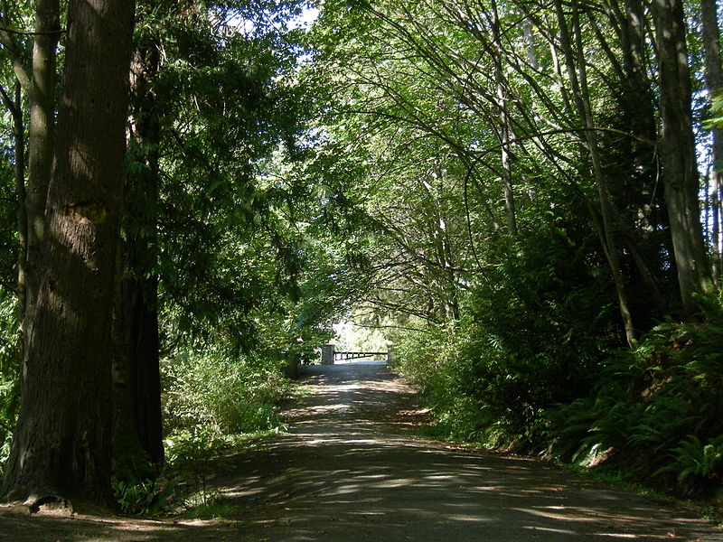
This road, and the park through which it runs, Schmitz Park (or Schmitz Preserve Park), was named for German immmigrants Ferdinand Schmitz (1860–1942) and his wife, Emma Althoff Schmitz (1864–1959). Ferdinand was a banker, city councilman, and parks commissioner. He and Emma donated land — mostly, though not entirely, old-growth forest — to the city in 1908, forming the core (just over 55%) of the present park.
The Schmitzes had four children: Dietrich, Henry, Emma Henrietta, and Ferdinand Jr. A banker, Dietrich (1890–1969) became president of Washington Mutual in 1934 and retired as chairman of the board two years before his death. He was also a member of the Seattle School Board from 1928 (or 1930; sources differ) to 1961. Henry (1892–1965) was president of the University of Washington from 1952 to 1958. Schmitz Hall, the university’s administration building on NE Campus Parkway, was named in his memory in 1970.
The roadway was originally envisioned as a continuation of the West Seattle Parkway, never realized, which would have connected Alki Beach to Lake Washington via a series of parkways. The built section is instead a short road that provided the only automobile entry to Schmitz Park, extending through an allée of trees and terminating at a pergola and shelterhouse.
Map of proposed West Seattle Parkway, cropped from a 1928 map showing both existing (red) and proposed (red hatched) park features. Schmitz Park and Boulevard are at upper left. Courtesy of the Seattle Municipal Archives, Identifier 2333.
The portion between 59th Avenue SW and 58th Avenue SW in front of Alki Elementary School having been closed in 1949, Schmitz Boulevard today begins at 58th Avenue SW and SW Stevens Street and goes not quite half a mile east, then southeast, then north, to SW Admiral Way and SW Stevens Street. It is closed to automobile traffic.
Emma Schmitz
Ferdinand Schmitz
Emma and Ferdinand Schmitz. Her photo is from the December 24, 1959, issue of the Seattle Post-Intelligencer (she had died December 23); his is from the August 23, 1942, issue of The Seattle Times (he had died August 21).
Born and raised in Seattle, Benjamin Donguk Lukoff had his interest in local history kindled at the age of six, when his father bought him settler granddaughter Sophie Frye Bass’s Pig-Tail Days in Old Seattle at the gift shop of the Museum of History and Industry. He studied English, Russian, and linguistics at the University of Washington, and went on to earn his master’s in English linguistics from University College London. His book of rephotography, Seattle Then and Now, was published in 2010. An updated version came out in 2015.
According to an article in the October 29, 1905, issue of the Seattle Post-Intelligencer, Robert bought the tract from H.M. Haller for $9,000. According to the obituary reproduced below, he was a “lumberman, contractor, and real estate man,” originally from Wisconsin, who had come to Seattle that very year, though he had been living in Washington since 1900.
Obituary of Robert James Patten, The Seattle Times, October 6, 1919
Patten Place W begins at W Armour Street just north of Bayview Playground and goes about 420 feet north to a dead end, though the undeveloped right-of-way continues on for about 250 feet more to the likewise undeveloped right-of-way of W Barrett Street.
Born and raised in Seattle, Benjamin Donguk Lukoff had his interest in local history kindled at the age of six, when his father bought him settler granddaughter Sophie Frye Bass’s Pig-Tail Days in Old Seattle at the gift shop of the Museum of History and Industry. He studied English, Russian, and linguistics at the University of Washington, and went on to earn his master’s in English linguistics from University College London. His book of rephotography, Seattle Then and Now, was published in 2010. An updated version came out in 2015.
Like Queen Anne Avenue N, Queen Anne Boulevard is named for the neighborhood and hill, themselves named for the Queen Anne architectural style popular with builders in the 1880s. Unlike the avenue, though, the boulevard is not one single street, but a scenic loop incorporating many streets (and hence has no directional designation, such as Queen Anne Boulevard W).
The legislation establishing Queen Anne Boulevard was passed in 1907, and construction took place from 1911 to 1916. The Seattle Department of Transportation has had jurisdiction over the streets since 1942; jurisdiction over the landscaping remains with Seattle Parks and Recreation.
The loop is slightly over 3⅔ miles in length; the ordinance gives its route as follows (edited for style and current street names and directional designations, with notes added):
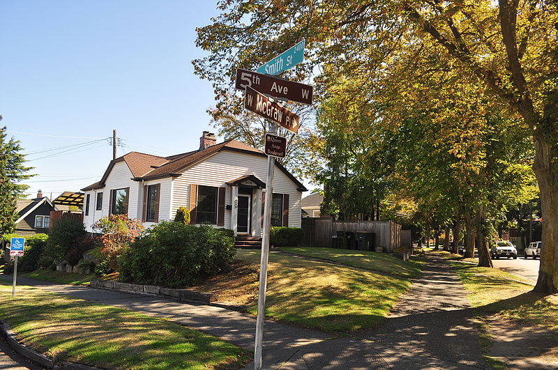
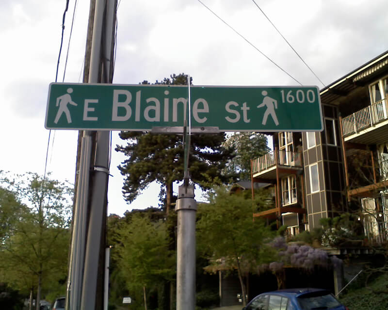
Extending from Prospect Street between Warren Avenue N and 2nd Avenue N, in a northeasterly direction*, to an intersection with Galer Street near Bigelow Avenue N; thence northerly following the general direction of Bigelow Avenue N as nearly as the contours of the ground will permit, to Wheeler Street; thence westerly to Nob Hill Avenue N; thence southerly to McGraw Street; thence westerly to 2nd Avenue N; thence northwesterly to Smith Street†, west of Warren Avenue N; thence westerly along Smith Street to a point east of 1st Avenue W; thence southerly to W McGraw Street and 2nd Avenue West‡; thence westerly to 3rd Avenue W; thence northwesterly to 5th Avenue W and W Smith Street§; thence northerly to W Raye Street; thence westerly to 8th Avenue W; thence northerly to W Armour Street; thence northwesterly to W Fulton Street; thence westerly to 9th Avenue W; thence southwesterly to 10th Avenue W and W Armour Street; thence southerly to W Wheeler Street; thence easterly to 8th Avenue W; thence southerly to W McGraw Street; thence easterly to 7th Avenue W; thence southerly to W Blaine Street; thence westerly to 8th Avenue W; thence southerly to W Lee Street; thence southeasterly to W Highland Drive and 7th Avenue West¶.
* Now the southern extension of Bigelow Avenue N. † Now McGraw Place. ‡ Now the east half of W McGraw Place. § Now the west half of W McGraw Place. ¶ Now 8th Place W.
Notably, there is a gap in the loop; Highland Drive between 7th Avenue W and Warren Avenue N could have made it closed, but this was not done.
“Queen Anne Boulevard, Seattle Historic Landmark” Parks Department sign, 1st Avenue W and W Smith Street, July 2015. Courtesy of the Seattle Municipal Archives, Identifier 178301
Queen Anne Boulevard at night: 8th Place W just north of Marshall Park, July 2015. Note the Wilcox Wall supporting the light fixtures. Courtesy of the Seattle Municipal Archives, Identifier 178303
Born and raised in Seattle, Benjamin Donguk Lukoff had his interest in local history kindled at the age of six, when his father bought him settler granddaughter Sophie Frye Bass’s Pig-Tail Days in Old Seattle at the gift shop of the Museum of History and Industry. He studied English, Russian, and linguistics at the University of Washington, and went on to earn his master’s in English linguistics from University College London. His book of rephotography, Seattle Then and Now, was published in 2010. An updated version came out in 2015.
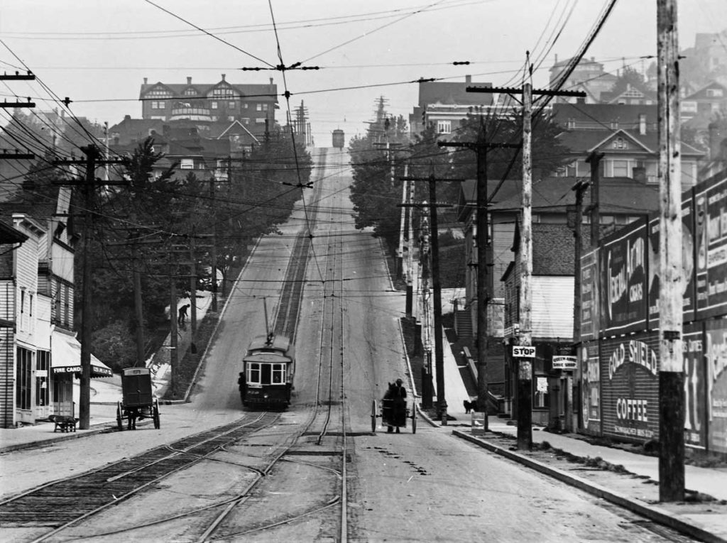
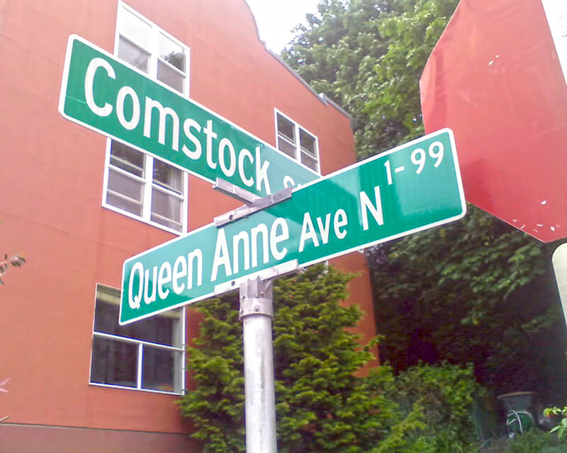
Originally Temperance Street and Villard Avenue, Queen Anne Avenue N was given its current name in 1895 as part of the Great Renaming. It was named after Queen Anne Hill and the Queen Anne neighborhood. Originally called Eden Hill or Galer Hill, they were themselves renamed after the Queen Anne architectural style that became popular in the 1880s.
Looking north up the Counterbalance (Queen Anne Avenue N), 1910
Queen Anne Avenue begins at Western Avenue, less than 100 feet south of Denny Way, and becomes Queen Anne Avenue N as it crosses Denny. From there it goes 2⅕ miles north to Bertona Street and the Ship Canal Trail.
Born and raised in Seattle, Benjamin Donguk Lukoff had his interest in local history kindled at the age of six, when his father bought him settler granddaughter Sophie Frye Bass’s Pig-Tail Days in Old Seattle at the gift shop of the Museum of History and Industry. He studied English, Russian, and linguistics at the University of Washington, and went on to earn his master’s in English linguistics from University College London. His book of rephotography, Seattle Then and Now, was published in 2010. An updated version came out in 2015.
This street was named for Mary Booth Hamblet (1840–1905), wife of Eli (1820–1905) and mother of Alonzo (1863–1937), namesake of Alonzo Avenue NW. The Hamblets were early Ballard settlers, and according to an article in the November 19, 1937 issue of The Seattle Times had their homestead where Ballard High School is today.
Mary Avenue NW begins at NW 67th Street just north of the high school and goes nearly 2 miles to the NW 105th Street right-of-way, where it becomes a trail leading to Carkeek Park. As I wrote in NW Blue Ridge Drive,
Ten or so years ago I saw a Private Property sign at the trailhead, put up by the Blue Ridge Club, but it was gone the next time I visited — I can’t remember if I complained or someone else did. (The woods are private, but the trail is Mary Avenue NW right-of-way.) This wasn’t in the original plat, but according to an old Flickr chat I had with Andreas “Severinus” Breuer, “there was apparently a WPA project approved to install a 30′-wide gravel road between 100th and 110th (apparently now NW Carkeek Park Road).… I imagine the ravine would look quite different if a 30′ gravel road had been put in, so presumably this plan wasn’t carried out. But a 1940 engineering map shows a surveyed ROW from 105th to the Carkeek border, and in Carkeek there seems to be a route that follows the WPA route (Clay Pit Trail > Hillside Trail > Brick Road Trail > Road). Perhaps the trail that exists today was made by the original surveyors or by WPA men?”
Born and raised in Seattle, Benjamin Donguk Lukoff had his interest in local history kindled at the age of six, when his father bought him settler granddaughter Sophie Frye Bass’s Pig-Tail Days in Old Seattle at the gift shop of the Museum of History and Industry. He studied English, Russian, and linguistics at the University of Washington, and went on to earn his master’s in English linguistics from University College London. His book of rephotography, Seattle Then and Now, was published in 2010. An updated version came out in 2015.
Plats named Cleopatra Park, 1st and 2nd Additions, were filed in 1905 and 1907 before Ballard was officially annexed to Seattle in May 1907 and before Ballard’s street names were revised to be consistent with the Seattle street system.… The owners of the Cleopatra Park Addition were Archie J. Johnson and his wife Linnie Johnson. We see that even though the property was in Ballard in Seattle, their plat filing document was notarized in Corvallis, Oregon.… Looking on the census of 1910 for this couple, we see the Johnsons recorded as living in Corvallis where Archie was the president of the Benton County State Bank. The census shows that Archie and Linnie Johnson had six children, all of whom were born in Oregon except their first child, daughter Cleopatra, who was born in Seattle in 1888.
Coming across Wedgwood in Seattle History and this post in particular, which also delves into the origins of Aloha Street and provides numerous resources for those who are interested in making their own discoveries, was one of the things that finally prodded me to get Writes of Way off the ground. Thank you, Valarie!
Born and raised in Seattle, Benjamin Donguk Lukoff had his interest in local history kindled at the age of six, when his father bought him settler granddaughter Sophie Frye Bass’s Pig-Tail Days in Old Seattle at the gift shop of the Museum of History and Industry. He studied English, Russian, and linguistics at the University of Washington, and went on to earn his master’s in English linguistics from University College London. His book of rephotography, Seattle Then and Now, was published in 2010. An updated version came out in 2015.
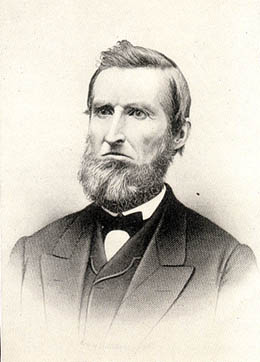
This street is named for Edward Hanford (1807–1884) and his wife, Abigail Jane Holgate (1824–1905), who left Iowa in the early 1850s to settle adjacent to Abigail’s brother, John (namesake of S Holgate Street), on what is today known as Beacon Hill but was known from then until the early 1890s as Holgate and Hanford Hill. Edward and his family were loggers, then orchardists, and unlike John Holgate, he went on to develop his donation claim.
The Hanfords’ son Clarence (1857–1920) founded, with James D. Lowman, the Lowman & Hanford Stationery and Printing Company in 1885. The firm went out of business in the 1960s, but their Pioneer Square building still, the last time I drove by, had a sign painted on it reading “Seattle’s Oldest Retail Company,” which it very well might have been when it closed. Their son Thaddeus (1847–1892) was for a time the owner of the Daily Intelligencer newspaper, predecessor of the Seattle Post-Intelligencer. And their son Cornelius (1849–1926), a federal judge from 1890 to 1912, was earlier a territorial legislator, Seattle city attorney, and chief justice of the Washington Supreme Court. He is the namesake of Hanford, Washington, and by extension the Hanford Site, which produced the plutonium used in the first nuclear explosion and the bombing of Nagasaki. He was also the author of Seattle and Environs, 1852-1924.
Edward Hanford
SW Hanford Street begins in West Seattle at SW Admiral Way and 59th Avenue SW and goes ¼ mile east to Schmitz Preserve Park at 56th Avenue SW. It begins again at 51st Avenue SW and goes nearly a mile east to 36th Avenue SW, becoming a stairway for the half-block east of 46th Avenue SW. After serving as little more than a driveway between SW Admiral Way and Fauntleroy Avenue SW, it next appears as S Hanford Street at E Marginal Way S, where it goes for ⅓ of a mile east to Occidental Avenue S. After a few short segments farther east in the Industrial District, Hanford begins again on Beacon Hill at 12th Avenue S and goes nearly a mile east to Rainier Avenue S, the segment between 25th Avenue S and Morse Avenue S being a stairway. It resumes a few blocks east at 30th Avenue S and finishes up ½ a mile east at Cascadia Avenue S.
Born and raised in Seattle, Benjamin Donguk Lukoff had his interest in local history kindled at the age of six, when his father bought him settler granddaughter Sophie Frye Bass’s Pig-Tail Days in Old Seattle at the gift shop of the Museum of History and Industry. He studied English, Russian, and linguistics at the University of Washington, and went on to earn his master’s in English linguistics from University College London. His book of rephotography, Seattle Then and Now, was published in 2010. An updated version came out in 2015.
We no longer remember the exact circumstances that led to the naming. The fable is that Stroud earned the name by clearing the road, though. Originally one block long, the road was in Wood’s Green Lake Home Addition in 1892 (filed by later-mayor William Wood). Also in 1892 Fred worked for John Wallingford, whose daughter Emma was married to William Wood.
Today, Stroud Avenue N begins at E Green Lake Drive N and goes ¼ mile northeast, then north, to N 82nd Street.
Born and raised in Seattle, Benjamin Donguk Lukoff had his interest in local history kindled at the age of six, when his father bought him settler granddaughter Sophie Frye Bass’s Pig-Tail Days in Old Seattle at the gift shop of the Museum of History and Industry. He studied English, Russian, and linguistics at the University of Washington, and went on to earn his master’s in English linguistics from University College London. His book of rephotography, Seattle Then and Now, was published in 2010. An updated version came out in 2015.
Unfortunately, though the Blaines may have been feminists, they, according to HistoryLink.org, had no love for Native Americans (or, for that matter, the Irish). Their departure in 1856 was prompted by the Battle of Seattle. Junius Rochester writes:
On January 20, 1856, a son John, was born to Catharine and David Blaine. Six days later the Battle of Seattle erupted. David had duty at one of the blockhouses, but managed to get Catharine and their babe aboard the Decatur in Elliott Bay. David had described the Indians as a “poor degraded race,” which would “soon disappear.” Catharine compared their “stupidity and awkwardness” to that of the Irish. The Indian uprising confirmed their worst fears and prejudices.
Today, W Blaine Street begins in Magnolia at 36th Avenue W and goes a semicircular ⅕ of a mile to 34th Avenue W and W Howe Street. It resumes at 31st Avenue W and goes almost ⅓ of a mile to Thorndyke Avenue W. There is a stub of W Blaine east of 15th Avenue W that is quickly stopped by the Southwest Queen Anne Greenbelt. The street resumes at 12th Avenue W and goes just over a mile to 4th Avenue N, having briefly become a stairway at 9th Avenue W. After a series of short stretches serving as driveways and parking, the Blaine Street right-of-way resurfaces east of Westlake Avenue N and heads into Lake Union. Here, too, it serves as a driveway and offers no access to the water. East of Lake Union, E Blaine Street begins at Fairview Avenue E and goes ⅛ of a mile to Franklin Avenue E, where it becomes part of the I-5 Colonnade park underneath the freeway. From Lakeview Boulevard E to just west of 10th Avenue E it is a stairway, and then two blocks of roadway ending at 12th Avenue E and Lake View Cemetery. There is then a diagonal ¼-mile stretch from 19th Avenue E to E Howe Street in Montlake. E Blaine finishes up as a ⅕-mile stretch from 37th Avenue E to McGilvra Boulevard E and a final two-block run from E Madison Street to 43rd Avenue E, both in Madison Park.
Born and raised in Seattle, Benjamin Donguk Lukoff had his interest in local history kindled at the age of six, when his father bought him settler granddaughter Sophie Frye Bass’s Pig-Tail Days in Old Seattle at the gift shop of the Museum of History and Industry. He studied English, Russian, and linguistics at the University of Washington, and went on to earn his master’s in English linguistics from University College London. His book of rephotography, Seattle Then and Now, was published in 2010. An updated version came out in 2015.
This photograph is undated, but must have been taken before Rezin left the family around 1880. Margaret sued Rezin for divorce that year and he “fled to California,” not to return for many years.
Pontius Avenue N runs ⅓ of a mile from John Street north to just past Mercer Street, where it dead-ends at the Interstate 5–Mercer Street interchange (originally constructed in 1962–1963 as part of the planned Bay Freeway, which was cancelled 10 years later with little more progress having been made. Its original northern end was Roy Street.) Pontius originally began one block further south, at Denny Way, but this portion was vacated as part of the construction of the Denny Substation.*
* Or was it? The clerk file indicates the vacation was granted, but I can find no related ordinance, and the King County Parcel Viewer and quarter section map show the Pontius right-of-way still existing between Denny and John. Something for me to look into… sometime.
Born and raised in Seattle, Benjamin Donguk Lukoff had his interest in local history kindled at the age of six, when his father bought him settler granddaughter Sophie Frye Bass’s Pig-Tail Days in Old Seattle at the gift shop of the Museum of History and Industry. He studied English, Russian, and linguistics at the University of Washington, and went on to earn his master’s in English linguistics from University College London. His book of rephotography, Seattle Then and Now, was published in 2010. An updated version came out in 2015.
Because Squire was the first to apply the name to a street, I count E Remington Court as ultimately being named after his wife, Ida, though one could say Greene’s preservation of the name, after the E Jefferson Street name had been extended by ordinance in 1895 from First Hill to Lake Washington, might also have been to honor his mother, Catherine.
Watson Carvosso Squire and his wife, Ida Remington, circa 1910
Born and raised in Seattle, Benjamin Donguk Lukoff had his interest in local history kindled at the age of six, when his father bought him settler granddaughter Sophie Frye Bass’s Pig-Tail Days in Old Seattle at the gift shop of the Museum of History and Industry. He studied English, Russian, and linguistics at the University of Washington, and went on to earn his master’s in English linguistics from University College London. His book of rephotography, Seattle Then and Now, was published in 2010. An updated version came out in 2015.
This short street in Seattle’s Windermere neighborhood runs from 60th Avenue NE and NE 55th Street in the southwest to 63rd Avenue NE and NE 57th Street in the northeast. It was likely named after Lochkelden, the mansion built in 1907 for Rolland Herschel Denny (1851–1939) and his wife, Alice Martha Kellogg Denny (1857–1940). Rolland was just six weeks old when the Denny Party landed at Alki Point in November 1851. Lochkelden — owned since 1974 by Sun Myung Moon’s Unification Church — was itself named for Lake Washington, of which it has a commanding view (loch being Scottish for ‘lake’) and its owners: Kellogg and Denny.
Note added March 14, 2024: It appears, per Clay Eals at PaulDorpat.com, that the church put Lockhelden on the market in 2022 and it just sold for $6 million. The purchasers are developers, and property owned by religious organizations cannot get landmark protection against the owner’s will, so the mansion’s days are almost certainly numbered.
Born and raised in Seattle, Benjamin Donguk Lukoff had his interest in local history kindled at the age of six, when his father bought him settler granddaughter Sophie Frye Bass’s Pig-Tail Days in Old Seattle at the gift shop of the Museum of History and Industry. He studied English, Russian, and linguistics at the University of Washington, and went on to earn his master’s in English linguistics from University College London. His book of rephotography, Seattle Then and Now, was published in 2010. An updated version came out in 2015.
The sleek Latona was originally built as a pleasure craft for businessman James Colman to use on the Sound. Dr. E.C. Kilbourne, a dentist with extensive real estate holdings north of Lake Union, purchased the Latona and took her to Lake Washington by way of the Duwamish River and Black River, the lake’s outlet. After a few years of serving farms, mining camps, and logging operations around Lake Washington, the Latona came through the narrow channel dug in 1886 to Portage Bay and thereafter served Lake Union.
Today, Latona Avenue NE begins as a shoreline street end just south of NE Northlake Way and goes nearly 1¾ miles north to 2nd Avenue NE and Woodlawn Avenue NE near the eastern end of Green Lake. It reappears on the other side of the Green Lake Park playground and community center at E Green Lake Drive N, and goes a further ⅓ of a mile to just past NE 77th Street, where it is stopped by Interstate 5. Finally, on the north side of I-5, it goes nearly ½ a mile from NE 81st Street to NE 91st Street, interrupted by a half-block segment just north of NE 88th Street where it takes the form of a footpath, and a half-block segment just north of NE 90th Street where it appears to have been incorporated into neighbors’ yards and driveways.
Latona Avenue NE right-of-way between NE 90th Street and NE 91st Street in Maple Leaf. The northern half is paved, but ends at an unpaved alley; the southern half appears to be serving as neighbors’ driveways at either end, the remainder being treated as part of their yards.
Born and raised in Seattle, Benjamin Donguk Lukoff had his interest in local history kindled at the age of six, when his father bought him settler granddaughter Sophie Frye Bass’s Pig-Tail Days in Old Seattle at the gift shop of the Museum of History and Industry. He studied English, Russian, and linguistics at the University of Washington, and went on to earn his master’s in English linguistics from University College London. His book of rephotography, Seattle Then and Now, was published in 2010. An updated version came out in 2015.
Born and raised in Seattle, Benjamin Donguk Lukoff had his interest in local history kindled at the age of six, when his father bought him settler granddaughter Sophie Frye Bass’s Pig-Tail Days in Old Seattle at the gift shop of the Museum of History and Industry. He studied English, Russian, and linguistics at the University of Washington, and went on to earn his master’s in English linguistics from University College London. His book of rephotography, Seattle Then and Now, was published in 2010. An updated version came out in 2015.
Undated daguerreotype portrait of Louisa Boren Denny
Today, E Louisa Street begins at Minor Avenue E and goes a block east to Yale Avenue E. It resumes half a block east at the alley west of Eastlake Avenue E and makes it 2½ blocks before being stopped by Interstate 5 at Boylston Avenue E. Resuming in the Montlake neighborhood just west of W Montlake Place E, it then goes ¼ mile east to 25th Avenue E.
Born and raised in Seattle, Benjamin Donguk Lukoff had his interest in local history kindled at the age of six, when his father bought him settler granddaughter Sophie Frye Bass’s Pig-Tail Days in Old Seattle at the gift shop of the Museum of History and Industry. He studied English, Russian, and linguistics at the University of Washington, and went on to earn his master’s in English linguistics from University College London. His book of rephotography, Seattle Then and Now, was published in 2010. An updated version came out in 2015.
This Magnolia street boasts one of the best views in all of Seattle — a completely unobstructed vista of Elliott Bay, Puget Sound, the Kitsap Peninsula, and the Olympic Mountains — if you’re fortunate enough to own property there. The view from the street itself is mostly of houses to the west, forested slope to the east. Notable Seattleites such as developer Martin Selig, broadcaster Kathi Goertzen, musician Ryan Lewis, and co-founder of Starbucks and Redhook Ale Brewery Gordon Bowker have called the winding lane — and it truly is a winding lane, hugging the bluff with barely enough room for two cars to pass each other — home.
The street was created as part of Carleton Beach Tracts, an Addition to the City of Seattle, Washington, on New Year’s Eve, 1920. The owners were Arthur Alexander Phinney (1885–1941), son of Guy Carleton Phinney, after whom Phinney Ridge and Phinney Avenue N are named; his wife, Daisy Euphemia Phinney (1884–1950); the Phinney Realty and Investment Company; and Oscar E. Jensen & Co., Inc. It begins at W Emerson Street in the north, just south of Discovery Park, and goes 1⅖ miles southeast to a roadblock a few feet beyond the bottom of the Montavista Stairs (more on that later). The roadway continues about 250 feet past the roadblock — all the buildings and lots on the west side belong to Martin Selig — and the right-of-way continues a little over 800 feet beyond that (see below for why).
The lane’s namesake had been a mystery to me for a long time, until I came across the Phinneys’ wedding announcement in the May 11, 1913, issue of the Seattle Post-Intelligencer:
Formal announcement made yesterday of the marriage at Victoria, B.C., May 2, of Miss Daisy E. Perkins, of Portland, to Mr. Arthur A. Phinney, of Seattle, contained the first intimation to local friends of Mr. Phinney of the nuptial event. The bride and groom had laid their plans in secret and protected this secret against all inquiring friends.
It seems, then, that we have a case similar to that of Thorndyke Avenue W — naming a prominent street after the wife’s maiden name.
For all its advantages, though — view, privacy (though it’s a public street, there are only a couple of ways to drive there from the rest of the city, plus two rickety staircases down from Magnolia Boulevard) — Perkins Lane has its faults, as the headline ‘Perkins Lane: Seattle’s Poster Child for Landslide Risk’ implies. A major landslide at the end of 1996 took out five or six houses, depending on whom you ask, at the southeast end of the street, and the adjoining roadway — hence the aforementioned roadblock. A lawsuit against the city, of course, was filed, but was dismissed at summary judgment. Slides had been a problem for the seven decades of Perkins Lane’s existence before that, as the images below attest. (The statute of limitations for false advertising has long elapsed, alas…)
Landslide at W Raye Street, with tilting utility pole, March 22, 1925. Courtesy of the Seattle Municipal Archives, Identifier 38072
Land for sale! Who was that civil engineer, I wonder… “No slides — Civil engineer says ‘Good condition to build on,’” 2461 Perkins Lane W, April 14, 1938. Courtesy of the Seattle Municipal Archives, Identifier 12194Landslide at 2445 Perkins Lane W, January 27, 1954. Courtesy of the Seattle Municipal Archives, Identifier 44997Ruins of house destroyed in Perkins Lane landslide on Magnolia beach in front of Magnolia bluff, Photograph by Flickr user Whitney H, licensed under Creative Commons Attribution-NonCommercial-NoDerivs 2.0 Generic
In fact, as the map below shows, there have been numerous slides over the years along the entire length of the road.
Perkins Lane W is also home to six of Seattle’s shoreline street ends — at W Bertona, Dravus, Barrett, Armour, Raye, and McGraw Streets, though McGraw is the only one currently accessible from land. The project to improve it back in 2013 and 2014 was not without opposition, but ultimately the threats never materialized (nor did the opponents’s fears). It’s well worth a visit.
Born and raised in Seattle, Benjamin Donguk Lukoff had his interest in local history kindled at the age of six, when his father bought him settler granddaughter Sophie Frye Bass’s Pig-Tail Days in Old Seattle at the gift shop of the Museum of History and Industry. He studied English, Russian, and linguistics at the University of Washington, and went on to earn his master’s in English linguistics from University College London. His book of rephotography, Seattle Then and Now, was published in 2010. An updated version came out in 2015.
This street, which runs ⅕ of a mile from the “five corners” intersection with NE 45th Street, NE 45th Place, and Union Bay Place NE in the northwest to NE 41st Street in the southeast, was created in 1911 as an extension of Union Bay Place. It was renamed in 1995 in honor of Mary Maxwell Gates (1929–1994), mother of Microsoft co-founder Bill Gates and a member of the University of Washington Board of Regents from 1975 to 1993.
The original proposal was to also change the name of NE 41st Street between Union Bay Place NE and Surber Drive NE to NE Mary Gates Memorial Drive, but this was not done. An article in the March 14, 1995, issue of The Seattle Times reports that “City Councilwoman Sue Donaldson said the Laurelhurst Community Club, the university and its neighbors near Union Bay Place Northeast joined yesterday in asking” for the name change, and an article in the September 1995 issue of Columns, then the name of the University of Washington alumni magazine, reports Donaldson as saying “The new name is particularly fitting… because it was the route Gates took from home to campus.”
I have never seen an explanation as to why the proposed name wasn’t simply Mary Gates Drive NE — it is the only “memorial” thoroughfare in town.
Born and raised in Seattle, Benjamin Donguk Lukoff had his interest in local history kindled at the age of six, when his father bought him settler granddaughter Sophie Frye Bass’s Pig-Tail Days in Old Seattle at the gift shop of the Museum of History and Industry. He studied English, Russian, and linguistics at the University of Washington, and went on to earn his master’s in English linguistics from University College London. His book of rephotography, Seattle Then and Now, was published in 2010. An updated version came out in 2015.


